Thursday, July 23, 2015

Denver Zoo


As some of our readers know, John and I have seen a fair number of zoos by now.  The Denver Zoo was not particularly on our radar to see, but we had a couple of free hours late Saturday afternoon, and it is close to Heather and Ann’s home.  Heather seems to love the place and was especially pleased that we were going there.  She has been there many times and proved to be a great guide for getting us around the place and into exhibit buildings out of the rain.  The zoo has 700 species, and 4,000 animals on 80 acres. 
What Heather likes about the zoo is that most of the animals are up and active and not sleepily lying around.  The polar bear in the picture above seemed to be enjoying the rain ( which was coming down from small to moderate amount of sprinkles the whole time we were at the zoo).  He is sitting on a ball, not sure what he plans to do with it!  I never did understand the different sections of the zoo, and how the animals were categorized, but the bear is in the Northern Shores exhibits. 
In the Tropical Discovery we found this interesting tree frog.  Its secretions are used in the treatment of aids and some cancers.  Native people use it as a mind-altering drug.  Because of those reasons it is a threatened species.   I believe it was in this area where I saw a sign noting that our rain forests are disappearing at an alarming rate.  Many scientists predict that the forests outside of parks and preserves may be gone by 2045.
The aquarium building had some wonderful displays, especially that of sea horses.  I find them rather unique and interesting creatures.  Equally fascinating is the sea bubble anemone, pictured above.  It can be found in the rocks and coral reefs of the Pacific Ocean.  It paralyzes and devours fish that brush against its tentacles.  However, the clown fish is immune and finds a safe haven among its tentacles.  Two clown fish can be seen hang out in the sea bubble anemone inthe picture above.
I also liked the pretty flowers and other decorative items displayed around the zoo, as pictured above.  In another area baskets and fabrics of Africa are displayed.  I must say we did have fun at the Denver Zoo, despite the rain and shortage of time!  It will be one of our more memorable zoos.

Tuesday, July 21, 2015

Golden, Colorado

We had a beautiful drive down here from Estes Park last week.  Our route took us through the Big Thompson Canyon and along the river by the same name.
We are now parked in Golden, Colorado.  Our plan was to be either in or near Denver because our niece Heather lives in Denver and our daughter was coming with son Nathan to plan with Heather the location of the next Lohrmann family reunion.  It has been a busy past few days, consequently.   However we did manage to find some time to explore Golden.  We walked the one main street in historic Golden.

There are wonderful sculptures all along the main street of the town, including that of Adolphus Herman Joseph Kuhrs (after arriving here from Germany in 1868 he changed his last name to Coors).  By 1880 he owned the Coors Brewery, along with a partner.  At the turn of the 21st century it is considered the largest single site brewery operation in the world.  During prohibition 17,391 gallons of the good brew were poured down Clear Creek.   To stay solvent at that time Coors began making near-beer and porcelain products.  It also supplied malt milk to the Mars Candy Company.  One cannot visit Golden without visiting the brewery, which we did at another time.
Running through town is Clear Creek, we walked across it on the Washington Avenue Bridge.  The creek is now flooded, a playground below the bridge is under water.  The creek must be a bane to this town, from 1859 (when the town was founded) to 1965 it flooded 25 times.  During the many times it went over its banks, crops, building and railroads were destroyed.   This, and other town historical information, is posted on plaques along the bridge.  We ate at the Capitol Grill, and discovered additional information regarding Golden.  The restaurant once was where legislative sessions were held for the Colorado Territory from 1862 to 1867.  As we walked around the town we noticed a rather striking large rock formation outside of town which makes a nice backdrop for the town.  It is called Table Mountain.


Thursday, July 16, 2015

Flowers and Wildlife in Rocky Mountain National Park


Bear with me on this, I was not going to bother with the plants and animals we saw on our hike Monday.  But I imagine you all know me by now, I cannot pass up taking pictures of them.  Saw some Indian paintbrush and also aven (yellow flower in picture above).  I learned at the Alpine Center that aven are pollinated by flies, and I did see some flies on these flowers.  The flower lies open for easy access.
There was a fair amount of forest diversity on our hike- from dry rocky slopes to to moist areas along streams.  Only in one area did we find ferns. and a one lone pink pipsissewa.  I am starting to learn the Colorado wildflowers!
 
A couple of different jays were flitting about, a gray and a stellar jay (pictured above).  And, lastly there were quite a few chipmunks.  One kept running ahead of us and when he stopped to munch he seemed totally oblivious to our presence or that I was taking his picture.  His cheeks are full!
 

Our second trip into Rocky Mountain National Park

To see much of the sights of the park it is necessary to do some hiking.  In 1964 ninety-five percent of the park was protected by the Wilderness Act.  In 2009 President Obama signed into law another wilderness act, protecting it even further.  No further roads or buildings may be constructed in the park.  On another note, the park is celebrating its centennial birthday, it was dedicated in September of 1915.
We did a full day of serious hiking Monday, despite a forecast predicting that the first of the monsoon  season was to start.  Pictured above is Bear Lake, with Hawlett Peak looming over it.  Mountaineer F.Chapin named it for his guide William Hallet in 1887.  From this lake we also had a good view of Longs Peak, the northernmost so-called fourteener" peak rising above 14,00  feet (according to park brochure).  We did not realize we were looking at the peak here until we bought a book on Bear Lake after the hike.
After we hiked Bear Lake the skies were overcast and rumbles of thunder could be heard.  We thought perhaps we could to a short hike to Nymph or Dream Lakes, but then on our way to them we saw signs pointing to Albert Falls, a further distance away.  By then the sun came out again and we decided to head for the falls.  Our path took us first to a steep rocky canyon with a mountain stream rushing down it.  We thought we were getting closer to the falls but we still had a distance to go.  It started sprinkling.
We made it to the falls and it started raining harder.  We pulled out our rain ponchos, but by the time we got them on we were just dealing with little sprinkles and the sky cleared up.  We headed back and, since the weather seemed to have improved, we decided to hike to Nymph Lake.  We knew that it would be a hard upward climb back to Bear Lake, and because of the uncertainty of the weather, we turned of the path and boarded a shuttle back to Bear Lake. From there we hiked to Nymph Lake.
The beauty of this lake are the many yellow water lilies floating on it.  By this time it was getting late in the day and time to head for home.  I still have more pictures to show of our day in the park, they will be in the next posting.


Wednesday, July 15, 2015

Plants and Animals of the Alpine Tundra

We encountered a bit of a traffic jam as we approached the highest point on Trail Ridge Road.  The problem was that many vehicles were stopping to see the elk.  According to a forest ranger a herd stays up here year around.  It seemed that they are quite use to people gawking at them!  Only other animal we saw way off in the distance was a fat marmot, who was sunning himself on some rocks.
At the Alpine Center there are wonderful exhibits displaying the varieties of wild flowers growing on the tundra, which number about one hundred.  Some of them grow so slowly that they will be only the size of a silver dollar after thirty years!   Summer is brief here, like about 3 months.  Plants have only that amount of  time to bloom and reproduce.  I was lucky to find a few forget-me-nots poking their heads up.  There are signs along the path to identify them.
The flower has a vegetable version of a fur coat, according to the interpretive sign near them.  Fine "fuzzy" hairs along its stem trap heat.  The flower has a sweet fragrance which draws honeybees- that may explain how the plant received its name. The delicate white flower near it is a white mountain avens.  It has an extensive root system which may reach up to 6 feet down into mineral- rich topsoil.
One flower which I saw a lot of on the tundra is the moss companion.  It, as well as many of the flowers in this area, hug the ground to protect it from harsh, drying winds.  The plant is tightly packed with leaves to conserve moisture and heat.  The dense greenery traps dirt which accumulates into topsoil. 
Some of the flowers on the tundra are dwarf versions of flowers found in lower areas, such is the case of the sunflowers pictured above.  As you may have noticed in the previous posting, there are many other types of yellow flowers up here as buttercups, avens, yellow stonecrop and the common dandelion. 
We spent one more day in the national park, more on that in the next posting.


Tuesday, July 14, 2015

Rocky Mountain National Park

We are now parked between Estes Park, Colorado and the national park.  Sunday we attended services at Shepherd of the Mountains Lutheran Church where we happened to see friends of ours from St.Louis, Nancy and Earl Matson.  It has been awhile since we last saw Nancy.  After the service we stayed for Bible class, and before it began several people started talking about the park and the recent profusion of wildflowers which can be seen on the alpine tundra.  It made us anxious to get there as soon as possible, like that very afternoon.  Also weather was not looking too good for the rest of the week.  Trail Ridge road in the park is the highest continuous paved highway in North America, and it brought us to the alpine tundra which encompasses nearly one third of Rocky Mountain National Park.  On the way up our first stop was at the lava cliffs.  They can be seen in the upper left side of the picture below.  After a volcano occurred many years ago glacial ice carved into the hillside and exposed the tuff in cross section.
As you can see, we had a very clear day with lots of sunshine.  At the top we had expected the temperature to be in the 40s, but it was a pleasant 57 degrees.  However, a brisk wind made it seemed cooler and jackets were required.  All along the drive we did see wildflowers, and on the walk at the top there were fields of them.  I will go into more detail on them in the next posting. 
The picture was taken at the highest point of the drive, which is about 12,000 feet above sea level.  The park has 72 named peaks above that elevation.  The Alpine Visitor Center is the Trail Ridge road's halfway point.  From the center there is a path leading to the highest point.  Hiking on the path to the top we had wonderful scenic vistas as well beautiful alpine landscapes, I never knew whether to look up or down!  The natural amphitheater below the center collects large amounts of snow often and at various times over the years.  It is blown across the mountains by the high winds common on the tundra.  The picture below shows our path down back to the visitor's center.
The hike was a bit strenuous, but the scenery was worth it!  Many people were on the path with us, including a toddler who was taking the steps on all fours.  His parents told me later that he did make it to the top!
Pictured above is Forest Canyon.  It was taken from a overlook we stopped at on our way down Trail Ridge road.  Glacial ice scoured the valley into a distinctive u-shape.  Forests of pine trees cover the broad valley.
There are several points of interest which I want to point out in the above picture.  In the foreground are trees which have been blasted by wind, ice, and grit.  Some branches that are on the downwind side survive.  Off to the right side of the picture is Trial Ridge road.  And the pale area on the left side of the picture is an alluvial fan, something John thought we had missed but later at home, while reviewing our pictures, we found out that we had seen it.  Alluvial fan is a large deposit of sand, gravel and other smaller materials built up by streams.  In 1982 a dam gave way at Lawn Lake and the raging waters carved out a valley for five miles before disgorging boulders, gravel, and sand onto the floor of Horseshoe Park- an area seen around the fan.  I need to post a disclaimer here, as some of the above information was obtained by the guide to Trail Ridge Road.  In my next posting I will have more on our drive through the park.


Monday, July 13, 2015

Continuing our Journey on Highway 36

One historic place along this highway which I did not mention in my last posting is in Oberlin, Kansas.  I did not write of it because the place has a connection with this posting.  In the late 1800s Cheyenne, Arapahoe, and Comanche Indians were still in the Great Plains.  Roving bands would attack settlers.  In Oberlin in 1878 was a Cheyenne massacre, the last chapter relating to Native Indian battles for Kansas. In Phillipsburg, Kansas, our one and only overnight stop in Kansas, we stayed in a city park called Fort Bissell.  Again I did my research after we had set up camp, and discovered that there really had been a Fort Bissell.  It was not a military fort, but one built by settlers in the 1870s for protection from the Indians.  Driving around the park that evening we saw a reproduction of the old fort.
And, very much on a whim, we stopped on our way out of the park the next morning, to tour the fort.  It was one stop I am glad we made.  We were greeted at the fort museum by a very friendly lady who is the curator of the museum.  She told us about how the old fort came to be constructed and how it came to be a joke for the Native Americans.  They would show up in the area, scare the settlers into running for the fort, all the while leaving unprotected their home and farms. The Indians had a lot of free stuff then for the taking!  Talking further with the curator we learned that she is an immigrant from South Africa who has been living in our country for only one year.  She spoke of her love for her home country and how she misses the animals there, as lions and elephants.  We also shared with her stories of our time on the road and what we had learned regarding American history.  She did  have a great deal of knowledge regarding the latter, especially with the history of the fort.  We could have chatted with her all day, but she had the museum to run and we needed to get back on the road after touring the fort.
The original fort had only one cabin and a lean to.  The reconstructed fort has several older buildings which have been moved in from other areas, as well as schoolhouse.  Pictured above is the Albright Cabin, built in 1873.  Mr.Albright's frequent visitor was Buffalo Bill Cody who spent many nights there.  Mr. Albright and his wife raised 6 children there, he lived to be 104 years of age.  Another building in the fort is a sod hut, built in 2007 by the Phillipsburg High School Band.  They were raising money to go to the Orange Bowl Parade.  Below is a picture of the inside of the sod hut.  It does look amazingly homey!
 
Small town historic societies continue to amaze us, it is amazing what they can cobble together with few resources available to them.  The stockade of the fort was built in 2007 by Stockton Correctional Facility. 
The fort also has some wonderful antiques collected from local people.  A first for us was a cigar lighter.  We imagined it was only owned by stores, for customers to light up.  It has a small kerosene tank on the side.
Highway 36 had one more surprise for us before leave Kansas, which was a rest stop.  Highway 36 has very few of them, and none for a 37 foot-long motor home!  In the town of Atwood we followed signs directing us to a rest stop and discovered a lovely city park next to Lake Atwood.
 
 And there was plenty of space to park our home for a brief stop.  That evening we parked outside of   Denver, further postings will be from Colorado.

Sunday, July 12, 2015

Highway 36 through Kansas


John never wants to repeat the highways we drive on during the many times we have crossed the states.  That is how we came to be traveling on Highway 36 across Kansas after we left St Joseph.   At first I thought it was going to a boring trip, as usual, across the Great Plains.  There are miles of corn, wheat and milo fields, and as the land became drier, only wheat and milo.  And very little traffic on the highway, other than farm equipment, especially combines as it is now harvest time in the wheat fields.   There are no bill boards to entertain us, and not even any distance markers indicating how far we have to go to the next town!  What there is, however, are quite a few signs indicating places of interest for the tourist to check out, as well as historical markers.
As we left St .Joseph and entered Kansas on Highway 36 we saw signs indicating turn-offs for historical Pony Express stables, as well as an old stage coach station.  We also saw a sign indicating the birthplace of the song “Home on the Range”.  I researched that later and discovered that Brewster Higley wrote those lyrics in a poem entitled “My Western Home” in the 1870s.  The town where that happened is near Smith Center, which is the historical geographical center of the 48 contiguous states.
We did not stop at any of the above places because we were on a time constraint, but where we did stop on our first day through Kansas was Mankato.  John needed a lunch break and the only place to pull over was on the main street of that town.  We have gone through so many small towns which have experienced the ravages of time that I thought I would take this opportunity to look closer at the town of Mankato.  It still has its old brick streets, as you may notice in the picture above.  Many shops are shuttered and closed.  A bowling alley looked like it had burned, the damaged lanes could be seen through an opened door.  Walking further down the street, one beautiful old building caught my eye.
 It used to be a bank, now is a chiropracter’s office.  Date on the bank building is 1887.   Next to it is the old Ute Theater, which presently is open only on week-ends with one show.  Across from those two buildings is the YMCA, date on it is 1880. 


 There is one drug store on the main street, it also has a small diner and drive-up pharmacy.   Other stores in the older buildings include hair styling salons, one quilt shop, antique stores and lodge halls.  In defense of this little town, walking off the main street I found a newer building which is a community center/library.  A convenience market/gas station was getting a lot of business, but they sold mainly candy and snacks.  I was informed that there is a small grocery store a block or two away. Towns like Mankato remind me that not everyone lives in large metropolitan areas with all the conveniences of the arts and shopping only a short distance away!   There will be more on our adventures on Highway 36 in my next posting.

Friday, July 10, 2015

St. Joseph, Part Two

As I wrote in the previous posting, the docent who gave us a tour of the Robidoux apartments was eager to share with us her knowledge of St. Joseph.  We learned a lot regarding the town from her.  It was once the home of Quaker Oats, the cracker factory of Saltines (in the museum are chandeliers from the founder of that company, Frank L. Sommer).  And do you remember Big Chief writing tablets?  They were made here.
Another informative museum pertaining to the history of St.Joseph is the Remington Nature Center, where "history and nature collide".  Here we learned more of the history of the town going back to the first Native Americans, as well as the fauna of the area.  Outside of the center is river walk alongside the Mighty Mo.
We also roamed the streets of St.Joesph in our car, looking for the various sights of the town as referred to in our tour book.  There is an actual Lovers Lane, immortalized by Eugene Field.  He courted his girl here and composed a poem in honor of what was then a country lane.
The words of the poem are: " a proper horse goes slow in those leafy aisles where Cupid smiles on Lovers Lane, St.Joseph".  Another interesting sight in the town is a mural which covers 6 buildings.  It is of a family starting their westward journey with their covered wagon.  In the foreground of the mural is a statue titled "Celebration", it is part of the downtown sculpture walk.
We also drove over to Fort Smith, which sits on a Telegraph Hill overlooking St.Joseph.
During the Civil War the Union had control of St.Joseph.  It was a vital hub for rail and waterways both to the west and north, and an important key to the Union's success during the war.  From this vantage point the army could see a good distance up the Missouri River as well as watch St.Joseph, a town which was evenly split between supporters of the Confederacy and the Union.
An important place for political rallies during the Civil War, as well as the headquarters for the Civil War Union Provost Marshal's office is the Patee Hotel, which opened in 1858.  It was also the headquarters for the Pony Express which operated from 1860 to 1861.  Mail was delivered between St.Joseph and Sacramento by a total of 80 riders.  It was replaced in 1862 by a railway postal car.
That was our day in St.Joseph, a very full one and we still had not seen everything!


Thursday, July 9, 2015

St. Joseph, Missouri


It seemed appropriate that, after spending 3 months in the rainy St. Louis area, we would leave the city in a rainstorm.  Fortunately, the further westward we went the rain abated.  Our first stop for the night was St. Joseph, Missouri.  We had visited the city in the past with our children and thought we had seen all the tourist attractions, which mainly amounted to the Jesse James house (where the outlaw had been shot) and  Pony Express Museum.  We received a tourism brochure of St. Joseph after we had parked for the night and learned that there were 13 museums in the city.   Our plans to leave the following day were quickly scrapped!
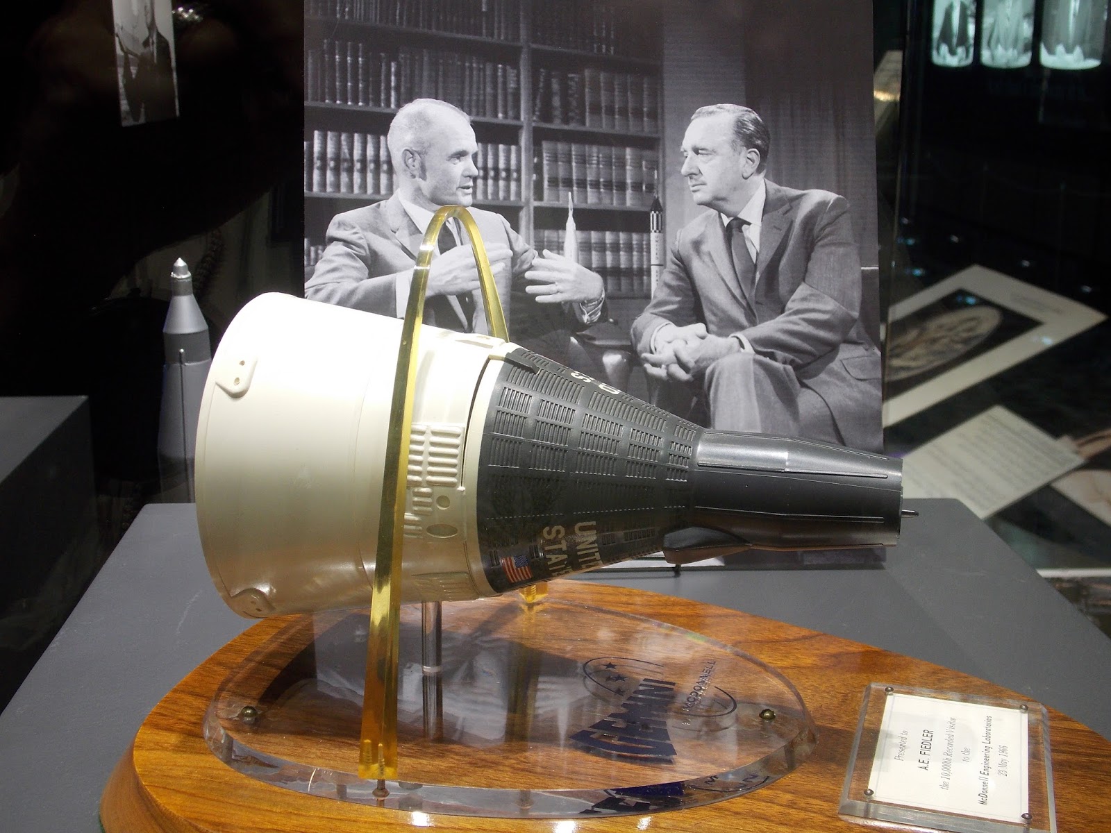
It was the vision of Dr. R. Varabedum, president of Missouri Western State University, that there be a memorial for Walter Cronkite, native son of St.Joseph.  The memorial was built on the campus of the university and dedicated in 2013.  It was was our first stop for the day.  This memorial has 19 exhibits pertaining to the life and work of the legendary CBS news anchor who became known as the most trusted man in America.  He covered World War ll and the Vietnam War, and interviewed Presidents Kennedy through Carter.  His broadcasts covered the beginning of the Mercury space program through the events relating to the space shuttle.
Pictured above is the 1967 interview of John Glenn with a replica of the Gemini model owned by Cronkite. It was distributed by McDonnell Engineering, many of you many recognize the presence of the St.Louis Arch over the Gemini model.   I most enjoyed the television display at the memorial which contains 39 images of world and national news events covered while Cronkite served as news anchor from 1962-1981.  Most memorable to me was his coverage of the assignation of President Kennedy.  Many of you may remember that he always ended his news hour with “and that is the way it is”. 

The rest of our day in St.Joesph on Wednesday was spent stepping further back into history- like 1843 when Joseph Robidoux, a fur trader, founded St.Joseph.  And yes, he named the city after his patron saint.  Back then many newcomers, coming up the Missouri River by steamboat, found it difficult to find lodging while their homes were being built.  To meet that need Robidoux built a series of connected apartments in the new town.  The four remaining units of Robidoux Row have been restored and are pictured above.  We were able to tour the inside, guided by a very knowledgeable docent.  The quarters are furnished with some of Robidoux's furnishings, and that of other family members.  Pictured below is a silk upholstered rocker brought from New Orleans by Roubidoux for his wife.
Before I conclude this posting I must mention the weasel, pictured below.
The weasel is used for measuring yarn, and 150 turns of it measures one hank of yarn.  After 150 turns the machine emits a popping sound, and thus the song "Pop goes the weasel" came about!
I will write more on St.Joesph in my next posting, we certainly put in a full day there.


Wednesday, July 1, 2015

St.Charles, Missouri

We will be parked for one more week here in St.Charles, and then will hit the road again.  It has been nice visiting family and friends, but we have had two tornado scares and that is enough.  The last one was Sunday when a tornado touched down about 10 miles from here.  There has also been a lot of rain which has created a lot of standing water that has brought on tiny insects. They have invaded our home.

A variety of circumstances has necessitated us staying in St.Charles longer than usual, so we have taken that time to explore the town.  One evening we happened to find Blanchette Park which has a small memorial garden.  While walking through it we came upon the "Christmas Box Angel".
A sign under the angel notes that the memorial is a place of love and healing for those who have lost children.  Flowers, trinkets, and toys have been placed at the base of the statue, as well as small stuffed animals which have been clipped on the angels wings.

It is a fairly easy walk on the Katy Trail from our home into historic St.Charles.  As I mentioned in an earlier posting several years ago, St.Charles was once an Indian village of 450 people which Lewis and Clark visited in the early 1800s.  From 1821 until 1825 it was the state capitol of Missouri.  The sign on the building says "Dry Goods Peck Bros. Hardware".  The first floor of the Peck brother's building housed a general store and Ruluff Peck's family residence.  The second floor of the two adjoining brick buildings was divided and used as the House and Senate chambers, an office for the governor and a small committee room.  Today it is a Missouri State Historic Site and visitors can take a guided tour through those rooms.
I always enjoy visiting Main Street in historic St.Charles.  Many of the area shops and restaurants and other historic attractions are housed in original 18th and 19th century buildings.  Pictured above is "Stone Row".  The buildings were built in 1820.  Burlington stone, used to construct the buildings, was quarried in the same city block.  Another interesting building, called the"Queen of Main Street" is pictured below.
It was built by the Odd Fellows Hall Association in 1878.  A bank occupied the first floor, a concert hall on the second and a Moose Lodge on the third floor.  Beside the many interesting older buildings, Main Street is quite picturesque with many small gardens which are quite pretty during this time of the year.