Sunday, September 30, 2012

Silver Springs- Part Two

Just before boarding a boat for our cruise around the main springs of the park I espied an anhinga doing what those water birds usually do when on shore, which is drying out their wings. We took our second river cruise around the main spring at the end of our day at the park.  We were informed by the captain of our glass-bottomed boat that there are around 120 smaller springs in the area.  They all form the Silver River- part of the inland waterway which which links the springs to the St.John River and Jacksonville, Florida.  The main spring which we traveled over is 65 feet long and 12 feet high.  In the picture below the bluer area of the water is where the springs are flowing into the river.  Our captain claimed that the water is 99.9 per cent pure partly because it gets filtered by the limestone and gravel in the river.  It provides water for the nearby town of Silver Springs and Ocala-  is also bottled and sold at Walmart stores under the name of Silver Springs.
As we looked through the glass bottom of our boat the water was very clear and we could see at least 40 feet down into the depths of the river. A variety of fish and turtles could be seen swimming among the eel grass.  Our tour guide then pointed out the white crystalline sparkle of the limestone in the river.  Most fascinating were the springs pouring out of the opening of a limestone cave.  I tried taking pictures with little success.  However, the one below can give you an idea of the ledge of the limestone cave.  It is the big splotch of white on the left side of the picture.
I thought that most of the underwater pictures I had taken were quite weird until we visited the Appleton Museum of Art at the College of Central Florida.  Currently on display there is the work of the artist Margaret Ross Tolbert.  When I first saw her paintings I commented to John that they looked like the underwater pictures which I had take yesterday.  Then we discovered that the artist swims in the springs of northern Florida and sketches underwater.  The art museum describes her work as "abstract expressionistic interpretations of our famous springs".  The lush hues of blues and greens in her paintings were exactly how we saw the springs underwater.   Our last river cruise proved to be the high point of our visit to the park yesterday.

Silver Springs, Florida- Part One

We have finally reached Florida!  It was great to finally reach this state after pushing the miles this past week.  Our joy on arriving here on Friday however, was short-lived when we realized how hot and muggy it is here.  And it did not help that a few scattered showers moved through on Friday, it just made everything wetter!  However, we did pick a great area to park in for over the week-end before we have to move on.  Silver Springs is the area of the world's largest formation of springs.  We had a great day on Saturday touring Silver Springs (touted as "natures theme park"), where the main springs is located.  It amounts to a zoo of sorts with the usual caged animals, as well as some animals and birds running freely through the park. There are many wild animal shows which are informative as well as entertaining.  My favorite was the bird show which had birds flying low over the audience.  In our travels we have seen the red tail hawk, but yesterday we had the experience of seeing his red tail feathers up close.  We also saw the smallest hawk to be found in the wild, which is the kestrel.  Also of interest to me was a variety of owls.
And who ever has wondered about Mexico's national bird?  It is the caracara, a mix between an eagle, a vulture, and a cousin to the falcon.  He is mostly a ground bird and his rather saucy attitude reminded me of the roadrunner. Tequila, the bird pictured below, would make an interesting cartoon character! 
Another bird, running free in the park and always underfoot, was the ibis- a pleasant change for us from the usual egrets and herons.  And speaking about wild and free, the park claims that 600 rhesus monkeys are running around in the area, as well as outside of the park.  I have since spoken to locals who dispute that there are that many around anymore.  They were imported into the park around 1938 with the hope that the Jungle Cruise would be enhanced by their presence.  Some think they were brought in for the movie Tarzan Finds a Son, which was filmed in the park- that is incorrect.  On the Jungle Cruise we saw two monkeys swinging high up in the trees.  We also saw a jeep which was left in the jungle from the Tarzan movie.  The park has a wilderness setting and most of the area is swampy with bald cypress trees and tall pines.  As most jungles it has numerous alligators, in one pond there are about 25 of them.  A big attraction of the theme park is the alligator feeding show.  Park staff dangle a piece of raw chicken on a pole above the pond and alligators jump out of the water to snatch the food.  Amazingly enough, not many of the gators rose for the bait.  They feed from April 1 until the end of October, after which they go dormant and do not eat.  Probably even now they are starting to get sluggish and are not in need of much food.  Below is a picture of the pond just before feeding time.  The gators were starting to gather and come in for the food.  One chicken was enough for the crowd.
While at the park we noticed a couple of alligators motionless for long periods of time with their mouths open- I at first thought they were not real until I notice their tongues pulsating.   We inquired of the park staff what that behavior was all about.  The information we received was that what they were doing was regulating their temperatures, one way of keeping cool.  Pictured below is a dwarf alligator keeping cool.
We did not think we would find enough to do in the park, but we spent five hours there.  I will continue this narrative of our time there in the next posting.

Friday, September 28, 2012

Congaree National Forest

After touring around Columbia, South Carolina on Wednesday, John and I were just not ready to head home.  However, it was around 4 PM and most museums and even the zoo would be closing.  Somehow John remembered reading about the only national park in South Carolina which was famous for its champion trees, trees that hold a record for size within their species.  In the park there are at least 20 such champions here, including loblolly pines, hickories, and bald cypress.  The park is about 20 miles southeast of downtown Columbia so we felt we could see it before it got dark.  The visitor's center was within about 10 minutes of closing when we got there,  but a park ranger took a few minutes to tell us about the park and encouraged us to take the self-guided boardwalk trail, located near the visitor's center.  Armed with brochures explaining what we were about to see,  we then headed out.  We soon came to realize that it was dumb on our part to head out into a swampy area at dusk with no insect repellant!  The mosquitoes sure enjoyed our walk, any time we slowed our pace they began munching on us!
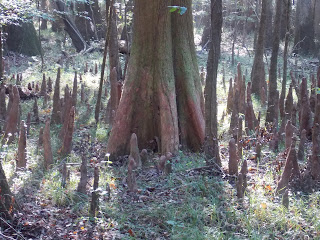
The above picture may seem a bit weird, but it was the only way I could show the forest canopy.  The forest canopy is said to be taller than any other deciduous forest on Earth.  Giant sweetgum, tupelo, ash, elm, along with several species of oak and hickory, form the canopy.  Along  the boardwalk were also loblolly pines which,  according to the information we had, stood from 150 to 167 feet high, some being 200 years old or more.  We also saw a bald cypress which was 27 in. circumference.  It was easy to readily identify the cypress trees because of their base which grows wide, to anchor the tree in the mud.  Their "knees",which in the park can be up to 7 1/2 feet high, could be seen everywhere on the forest floor.
  Speaking of mud, the Congaree floodplain floods about 10 times a year.  Floodwaters deposit rich soils whose nutrients support the complex plant community of the park, including the giant trees.  Speaking of diverse plants, along the boardwalk we noticed a variety of them.  There is a paw paw grove, as well as areas of ferns and switch cane.  South Carolina is called the Palmetto State, and the cabbage palm is the state tree.  In the swamp area along the boardwalk is a patch of palmettos, the variety of which is a close relative of the cabbage palm.  There are 22 different plant communities in the whole park.
Park information told us that we were walking "in the footprints of the Wateree and Congaree Indians, Francis"Swampfox" Marion, and Harry Hampton".  Bootleggers also hung out here; off the trail in the distance we saw an iron box, in which they hid their still.  While hiking we stopped at Lake Weston, it once was a bend in the Congaree River and  is now an oxbow lake that is slowly filling with clay and humus. Here we saw several large turtles swimming at the shore line.  Maybe they were hoping we would feed them!


Wednesday, September 26, 2012

Columbia, South Carolina

On Monday we left Washington D.C. and continued our journey south.  Presently we are outside of Columbia, South Carolina.  It was interesting to watch the countryside change as we traveled more inland.  I got excited when we started seeing cotton fields, red clay, palm trees and tall pines.  Change is always good, which is why we chose the life style we have.  In D.C. nights were starting to get chilly, we even needed to turn on our heater in the early mornings.  Now we are turning on the air conditioner during the daytime hours!   On our route through North Carolina I noticed along the highway, which we were traveling on, historical markers noting that Major General William Sherman's armies had come through certain areas of the state in 1865.  Since we have been in South Carolina I have learned more about that history.  After burning Atlanta and capturing Savannah in December of 1864, General Sherman went north into the Carolinas in the spring of  1865.  He had his eye on destroying Columbia, South Carolina because the secession movement of the southern states started there.  We took a tour of the state house today and received a most wonderful history lesson of the state from our guide.  We learned that when General Sherman arrived in February of 1865 he burned the wooden state house and shot 6 cannon balls at the new state house, which at time was only in the early stages of construction.  The damage to the current state house can still be seen today.  Bronze stars mark where the artillery fire hit, and cracks in the stone from the damage are visible.
From 1867 to the mid 1880s little major work was done on the state house.  Much of the present interior work was completed from 1885 to 1895.  The copper dome and porticos were completed by 1907.  The main lobby is adorned with paintings, plaques, and statues that reflect the history of the state.  While explaining them our guide noted that the state had more battles within its borders during the Revolutionary War than any other colony on the east coast.  During the Civil War confrontations only happened at Fort Sumter and at Columbia.  Overlooking the main lobby is beautiful mosaic glass depicting the Seal of South Carolina.  The glass art can also be seen above the three entry doors shown below.
Across from the state house is Trinity Episcopal Church, built in 1812. Constructed in English Gothic, it was modeled after Britain's York Cathedral.  During the Civil War its iron spires were melted down to provide cannon balls for the Confederacy.  The sanctuary was not seriously damaged when Sherman burned the city.


Tuesday, September 25, 2012

The Franciscan Monastery of Washington,D.C.

We toured this monastery Sunday with our son Daniel and his wife Amanda.  As usual, what I expected in viewing this place turned out to be a bit different than what we actually encountered.  Guess I thought we were going to tour the dwelling place of a community of Franciscans, instead our guided visit was mainly that of the church itself, and the monastery gardens.  You may notice that above the entry to the church there is a red cross, the Jerusalem Cross.  It  pretty much sums up what this religious institution is all about.  The seal of the Custody of the Holy Land is a five-fold cross of Jerusalem, used by the crusaders on their banners.  For over 750 years the Franciscans have succeeded in the conquest and the preservation of the Holy Places in the Holy Land.  In 1887 the founder of the Franciscan Monastery, Rev.Godfrey Schilling, established this monastery in Washington D.C. for the purpose of training Franciscan Missionaries for the preservation of the Shrines of the Holy Land, as well as providing a place here in America for people to see the Shrines of the Holy Land as well as the Catacombs of Rome.  The structure of the church  follows the five-fold cross, the large cross constitutes the main body of the church, and the small ones the chapels.  Our first stop in the sanctuary was at the Holy Sepulchre, a faithful copy of the same place in Jerusalem.  Looking from that point our gaze focused on the Altar of Calvary, a replica of the original in Jerusalem.  The distance in the church from Calvary to the grave of Christ  is the same distance as that of the same sites in the Holy Land. 
In the center of the church is an altar dedicated to the Most Holy Trinity. A copper canopy, supported by 4 bronze pillars each with figures of three disciples, stands over it.  There are many more features of the church's sanctuary which I have not mentioned here; suffice it for me just to say that it is all quite beautiful with the stained glass, marble alters and narrative wood carvings.  Below the main church we toured the catacombs, which we were told are faithful copies of those in Rome.  From there a short passageway led us to the Chapel of Purgatory.  We then retraced our steps and came to the Nativity Grotto.
The altar in the center niche is like that of the Nativity in Bethlehem., beneath which a silver star commemorates the place where Christ was born. The tour with our guide ended here, and we moved outside to walk in the monastery gardens.   A beautiful rose garden surrounds the statue of Saint Bernadete.
In front of the rose garden is the Grotto of Lourdes,  a replica of the one in southern France. Also in our walk of the gardens we came upon the Ascension Chapel, a replica of the one on the Mount of Olives in the Holy Land.  And in this valley of shrines are the Stations of the Cross, which are of Franciscan origin.  Near the monastery church is a replica of the Portiuncula Chapel, the first church of St.Francis of Assisi.  Surrounding the monastery church is a Rosary Portico, on the colonades of its 10 arches are inscribed the words of the Hail Mary in 150 languages. One cannot help but be impressed by the peacefulness and beauty of this Franciscan Monastery.

Friday, September 21, 2012

Eastern Shore of Maryland

There is plenty yet for us to discover both in Washington D.C. and Baltimore, but when John suggested a drive to the eastern shore, I readily agreed.  I think that both of us had enough of the craziness and hectic pace of large cities!  Wednesday was going to be perhaps our only free day of the week, so that seemed to be a good choice.  From Baltimore we crossed the Chesapeake Bay Bridge and soon we were driving through farm land and forests, which pretty much characterizes the nature of the northern section of the eastern shore.  We followed signs to the scenic by-way SR 213 which, according to our tour books, claimed to offer easiest access to scenic and historic attractions.  In the town of Wye Mills we found the Old Wye Mill, which produced flour for George Washington's troops at Valley Forge.  Near the mill is Wye Church, a restored Colonial building with a flying pulpit and box pews.  As you can see in the picture below, next to the pulpit are two lecterns, they are located in the middle of the church, not at the chancel.  On the walls are candle holders, the church is still being lit only with candles.  Also hanging from the balcony is the coat of arms of King George I (Queen Victoria, 1837).  The Vestry House, built in 1763, is near the church.
We found a lady in the church office who gave us written information of the history of the church and its physical features.  According to that information William of Orange was the King of England in the 1600s (William and Mary) and he sent a new governor to make the Church of England the official church of the Colony of Mary Land.  At St.Luke's,Wye the earliest religious services were held as early as 1658.  The church was built in 1721 and once in its history served as a stable.  We were also encouraged by the church secretary to check out Orell's Maryland Beaten Biscuit Company, located next door to the church.  We would never had known that the company was there because the place next door is a 100 year-old farmhouse!  It was fortunate they were open the day we were there, as they are only open for visitors on Wednesdays.  We got a tour of the factory and samples of the hard biscuits.  The company has flavored varieties, of which honey was the only kind left for us to taste.  They are quite good, unfortunately the secret ingredient which makes them so tasty is lard!   While we were there several ladies were sitting at a kitchen table preparing the rolls for the oven.  Prior to this stage it is necessary for them to be beaten in some manner, it use to be with a hammer or mallet, now it is a rolling machine.  Watching them at work we soon realized that there is a skill required in forming the biscuits.  The older woman has been working on them for 48 years,  for another lady it was her first day.  They turn out an average of 160 dozen biscuits (1,920) a day and have a very large mail order business. 
Our last stop for the day was at the town of Oxford.  It lies on the tip of a peninsula between the Tred Avon and Choptank Rivers.  While we were standing at the harbor the Oxford-Bellevue Ferry came in, it is believed to be oldest privately operated  ferry service in the United States.  It has been operating since 1836.
A local policeman stopped to talk to us at the harbor.  He encouraged us to check out the painted picket fences which are located at various places through out the town.  That was a good ending to our day.

Wednesday, September 19, 2012

Capitol Hill Neighborhood of Washington,D.C.

Sunday morning we attended First Trinity Lutheran Church in downtown Washington, D.C.  The Gospel lesson for the day was acted out by the Lifeline Partnership, adults with developmental and intellectual disabilities.  It is one of several social ministries with which the congregation is actively involved.  First Trinity also has a hostel and housing ministry, as well as a public restaurant which provides job training for the unemployed.  We enjoyed talking with Pastors Wendy Moen and Tom Knoll after the service, as well as other members of the congregation.  The church certainly has an exciting ministry to the community and, unlike other churches we have visited, it has young adults active in its worship and mission activities.  After church our son Dan suggested a trip over to the Eastern Market on Capitol Hill.  It is the second market bearing its name, the first one started in 1805 and lasted until 1872.  In its earliest beginnings it was situated near the Anacostia River.  It was a time when markets relied on river transportation to move goods.
 In 1873 a building was built at its present location, and in that building we found many vendors selling a wide variety of fruits, vegetables, meats and flowers.  Somewhat similar to Soulard Market back in St.Louis.
 Outside the building was a very large flea market.  Strong neighborhood support through the years has kept the market going.  Opened 6 days a week, it is Washington's oldest continuously operating farmer's market.

 Especially on weekends the market is quite active with many craft booths, antique dealers as well as musicians.  While strolling around the market we came upon the Capitol Hillbillies.  The pianist pounded wildly on the keyboard, sometimes even using his forearms, it was amazing that the piano didn't bounce off the little cart upon which it was perched!  The two musicians were very entertaining and the ragtime music was good.  While we were there the pianist asked for help from the audience to play his tambourine.  Daniel was happy to oblige.
From the market we walked through part of the Capitol Hill Neighborhood.  The first city planner for Washington, Pierre L'Enfant, chose this area for the Federal House ( U.S. Capitol).  He ran into some confrontations with local landowners and was relived of further responsibilities.  Once known as Navy Yard, Capitol Hill is the oldest residential area of  Washington city.  Now the Navy yard is no longer the area's major employer, but the U.S. Navy and the U.S. Marine Corps still anchor this residential community.  It is a mixture of row houses mixed with two-story frame houses.  Many of the small front yards are quite pretty with flower gardens, brick walkways and wrought iron fences.  And we were surprised to accidentally find the house where John Philip Sousa was born in 1854.

Tuesday, September 18, 2012

Brookland Neighborhood of Washington, D.C.

Brookland lies in the northeast quadrant of Washington, D.C.  It is where our son Daniel and his wife Amanda now reside.  Shortly after we had arrived, on Friday, they took us on a walking tour of their neighborhood.  Brookland has been called "little Rome" by some,  for the many Catholic institutions clustered around the Catholic University of America, which is located within its borders.  In 1910 Bishop Thomas J.Shahan, rector of The Catholic University of America, suggested building a national shrine to honor Mary, the mother of Jesus Christ.  The Crypt Church (located in the lower level of the present church)  was completed in 1926.  It is pictured below.
 In 1953-54 the American Catholic Bishops renewed the effort to complete the church, and in 1959 the shrine was completed.  It is the largest Catholic church in the United States, having 70 chapels and oratories.  The shrine houses a large collection of 20th century mosaics.  The one most fascinating to me was  "Christ in Majesty" done by John de Rosen.   In the art work Christ has his left eyebrow raised, indicating judgment. His right eyebrow is lowered, showing the compassionate side of Christ.
In our walking tour of Brookland we also stopped at the church of Howard University Divinity School, founded in 1867.  We were given to understand that the edifice was once owned by the Catholic Church.
It is an unusual building with tall figures of saints adorning the outside walls.  I have one last institution in Brookland to mention, that of Colonel Brooks Tavern.  The neighborhood of Brookland sits on what use to be his farm estate in the mid 1800s, and he is honored for that distinction with his portrait hung above the bar.  Unfortunately as of Saturday the tavern is now closed.  We had a wonderful meal there that day. 


Baltimore, Maryland

We have now parked on the Fort Meade army base. Before going any further, I probably should continue my review of our watery east coast journey southward last Wednesday.  Tuesday night we were outside of Trenton, New Jersey.  In Trenton we crossed the Delaware River- as George Washington did in 1776 before the Battle of Trenton against the British.  New Jersey's border is at the easternmost shoreline of the river.  From there we were back in Pennsylvania, Philadelphia to be exact.  The Susquehanna River was our next river crossing, it is the longest river of northeastern United States and  flows through southeastern Pennsylvania  into northeastern Maryland.  Baltimore,Maryland was our final destination where we planned to stay for a couple of weeks. This picture was taken as we drove past Baltimore Harbor into the city.
Most of the campgrounds which we checked in the D.C. area were full during the time we would be in the area.  However, we could use a military park because our daughter Melissa's fiance is in the Navy.  And Fort Meade, outside Baltimore, had an opening for us.  Unfortunately we arrived there rather ignominiously on Wednesday afternoon.   John chose the gate of the National Security Agency in which to enter with our motor home!   Police cars with sirens blasting and lights flashing halted us.  Once we explained where we were going they were a bit kinder to us and escorted us out of that area- after they had a dog sniff every compartment of our home, inside and out.  Our cat KC had to be carried out for the inspection.  I marvel at what that cat has experienced in his lifetime!   The rest of our past week has been spent at our son Daniel and his wife Amanda's home.  They recently purchased a 100 year-old home and John has been helping them with repairs.  The home is pictured below.  Our daughter Melissa has also chosen this time to move from her apartment in Fairfax to another one closer into D.C.   We spent one evening with her helping her to pack.  However, in our first week here we still have found time to do some sight-seeing.  More on that later.


Tuesday, September 11, 2012

Rhode Island to New Jersey

We had a very interesting trip down Interstate 95 from Rhode Island yesterday.  You can pretty much call it the major coastal highway from Maine to Florida.  Yes, it is pretty much built up, with major cities along its path, but other than some areas where there is construction going on, we were able to keep going without getting into big traffic jams.  We even breezed through New York at rush hour with no problem.  What made the trip interesting for us was the waterways, and bridges over them, which we crossed yesterday.   Our first water crossing in Connecticut was at Mystic Seaport.  At New London we crossed the Thames River.  New Haven proved to be a large metropolitan area, it has the Naugatuck and Housatonic River flowing through it and into the ocean.  And at Fairfield we crossed the Saugatuck Reservoir, created by the damming of the Saugatuck River.  At New York city, still on Interstate 95, we crossed the Hudson River on the George Washington suspension bridge.  Pictured below is the skyline of the city, most unfortunately we kept going at a rather good clip through the city so it was difficult to snap pictures from our motor home.
It being the date of 9/11, I thought it fitting to post the above picture.  The tallest building is the Freedom Tower, which has been built since that sad day in our nation's history. 

Monday, September 10, 2012

Providence and a return to Newport

My new camera stopped working, so I cannot use pictures to help tell my story for this posting.  In some ways that may be good!  I think it will hone my writing style,as this calls for a different approach.  Friday morning, on our way to downtown Providence,we stopped at a peach orchard near where we are parked.  That was one experience I will never forget.  The peaches were so ripe they were dropping to the ground, every few minutes I would hear a loud "plop".  It was a small orchard but there were about a dozen different varieties of peaches and apples.  Before we went off to pick our peaches the owner pointed to a poster on his shed wall where we could note which kind of peaches were ripe at the present time.  He encouraged us to sample the different varieties before deciding which one to pick.  It was peach heaven for me, every peach was big and juicy!  We left with about 12 pounds of peaches.
We went into Providence primarily to tour the capital.  The statehouse overlooks the city.  A large marble dome caps the building and a gilded bronze statue, "Independent Man", stands atop the dome.  Inside are interesting relics as the original parchment charter of 1663 granted by King Charles ll, and two Civil War cannons from  the First R.I. Light Artillery.  In the State Reception Room is the famous Gilbert Stuart portrait  of George Washington.  From the capital we walked down into the city and along Waterplace Park.  Providence and Woonasquatucket Rivers pass through the downtown.
On Saturday we returned to Newport to hike the Cliff Walk with our niece Karen, her husband Paul and their two boys.  It was a breezy and warm day, but the bluffs of the walk skirt Rhode Island Sound so the breeze from the ocean kept us cool.  The trail is rough at points, and we sometimes had to do some rock scrambling.  However, it offered us some beautiful vistas of the rocky coastline, and occasionally a glimpse of the massive summer cottages hidden behind manicured hedges.  I really missed not having a camera here!  We hiked all 3 miles of the walk, but the boys were still running circles around us.  They had not tired.
Sunday  John and I returned to the orchards with Karen and Paul's two boys in tow.  We had offered to watch them for the afternoon and figured it was something they would enjoy.  The frogs in the pond entertained them for a few minutes, and they picked a small bag of fruit.  By then I had a working camera. 

Saturday, September 8, 2012

Newport, Rhode Island

Newport was settled in 1639,and by 1646 had established itself as a shipbuilding center.  It was once the hub of Colonial commerce,and remains still a busy seaport. Today,from its docks,large sailing ships as well as massive ocean liners can be seen.  As John and I walked along the harbor we noticed that some of the old stone walls of the wharf are still present.  We felt like time travelers yesterday as toured the town of Newport.  We walked from Long Wharf to Colony House, fairly much the same path which George Washington took in 1781.  At Colony House he met with the French General de Rochanbeau to begin planning battle against the British in Yorktown,Virginia.  Colony House is said to be the nation's oldest capital, it was the State House from 1776-1900.  Presidents Dwight Eisenhower,Thomas Jefferson, Andrew Jackson were said to have been entertained here.
Our walking tour of Newport took us also to the oldest Jewish synagogue in the United States, built in 1763.  It stands on a lot at an angle so that the ark which holds the Torahs faces east toward Jerusalem.  The park surrounding it is a memorial to all Early American Jewish Patriots.
While in Newport we also drove on Ocean Drive which took us along the rugged Atlantic coastline.  Large summer homes border the drive, some of which were built during the Gilded Age and since have been maintained by the Preservation Society of Newport County.  During the late 1800s Newport became the hot spot for the elite- here the Astors and the Vanderbilts erected their summer mansions.  We toured The Breakers, summer retreat of Cornelius Vanderbilt who built it with fortunes from the New York Central Railroad.  It is a 70-room Italian Renaissance estate with a two and half story high Great Hall complete with a grand staircase.  Original furnishings and decorative details reflect the wealth of the Vanderbilts, which can be seen in the imported French and Italian alabaster and marble, ceiling paintings, platinum leaf panels, and gilded woods. Over the years this summer home was the scene for memorable family galas as weddings and debutante balls. The family lived in it from 1895-1938.   The sweeping back lawn flows down to the shores of the ocean, as do many of the other Newport Mansions.
We concluded our trip to Newport with a lovely supper of lobster crepes and Rhode Island clam chowder, which we enjoyed in a restaurant overlooking Narragansett Bay.

Thursday, September 6, 2012

Narragansett, Rhode Island

Our home is now parked outside of Providence, Rhode Island.  We have a niece, Karen and her husband Paul, who recently have moved here from New Hampshire.  It has been great visiting them and their two boys once again.  We have had a couple of days of heavy rain, I understand it is a gift from Hurricane Isaac.  By late afternoon yesterday the sun finally came out again and we ventured forth to the town of Narragansett.  The town forms the southernmost tip of Rhode Island's famous Narragansett Bay.  John and I were faithfully following our navigation's systems instructions to find the statute of Canonchet, and after we found it, our eyes were instantly caught by the sight of two very large stone towers.  We later discovered, from interpretive signs in the area, that they are the " most universally cherished landmarks in the state of Rhode Island".  The stone structures were originally part of a much larger building, the Narragansett Casino constructed in 1886.  Before the Narragansett Pier burned in 1900, the town was one of the foremost seaside resorts of the nineteenth century.  A fire in one of the town's hotels swept through the town and destroyed the pier and the casino.   Only left standing were the stone towers.  The casino was rebuilt in 1905,  another fire destroyed it in 1956.  Still the Towers endured.  There were also the enormous hurricanes of 1938, 1954,and 1991 (each of which decimated surrounding structures) and the Towers still remained standing.  Today there is a Great Hall above the towers which has been used as the site of memorable galas for more than a century.  From the Towers we had a wonderful view of the bay.
I find it a bit hard to believe that about nine months back we were on the shores of the west coast looking at the Pacific Ocean, and now we are on the shores of the Atlantic Ocean.  Many people were in the water, surfing seems to be a popular sport here as well as in California.
I mentioned a Native American statue that we came to this area to see, that of Chief Canonchet.  He was the war leader of the Narragansett when the United Colonies attacked their winter fort in 1675.  He was caught and executed by our government in 1676, after he had led the Great Spring Offensive against the colonies.  Strangely enough, the commemorative marker under his statue notes that he was a "friend, benefactor, protector, warrior, hero and martyr". The quote was made by Thomas Bicknell in 1920.
 Seems to me that there is more to the story of Chief Canonchet!  The rest of our time in Narragansett was spent walking around the town where there are numerous large seaside resorts/homes, and colorful gardens.

Tuesday, September 4, 2012

Clocks and Carousels

We had considered visiting New York city by train on the last day we had in Connecticut.  However, that would involve a lot of  travel time and there was still plenty to see just in the area where we were parked, which was Thomaston.  That town once was the home of the Seth Thomas clock factory.  A town near Thomaston, Bristol, was the world's leader in the production of affordable time pieces in 1844.  At one time in the early 1800s there were more than 200 companies of varying sizes engaged in the manufacturing or assembly of clock movements and cabinets within a 12-15 mile radius of Bristol.  No surprise, then, that the American Clock and Watch Museum is located in Bristol!  The museum is housed in a structure built in 1801, which needed the addition of two wings to display 3,000 clocks and watches. It is a superb collection of clocks and watches spanning two centuries.  And there is every type of clock on display; from shelf clocks to grandfather clocks, to church tower clocks, novelty clocks and atomic clocks (to name only a few of the many types found in the museum).  There are also a wide variety of watches, and period furniture.
A great deal of the charm in visiting a museum like this one is hearing the ticking, chiming and striking of all of the various clocks on the hour and half hour.  We had an equally fascinating time at The New England Carousel  Museum.  There is a guide for visitors through this museum and our guide pointed out to us that it is a working museum.  In the museum are rooms for restoring and preserving the antique carousel animals.  Most carousel new carousel  animals now are made of molded plastic. However, new carousel animals created by this museum are carved from wood.  The wooden horses are created from many layers of wood and are held together by animal hide glue.  No nails are used or screws are needed.   Pictured below is the room where they are painted or, if antique, touched up with new paint.
Many different antique carousel animals are on display in the museum.  Pictured below is the Lincoln Head Penny Horse.  It was created in 1909 to commemorate the issuing of the Lincoln Head Penny.  It was made by Marcus Illions, one of the top ten carvers at the turn- of- the- century.  Only three of these horses were made, and of the three, the one pictured below is the last one remaining today. All of the horse's hoofs are up, so it is a jumper horse, one that can move up and down.  The other two types of carousel horses are prancers and standers, their hoofs are in different positions and on the carousel they have no movement.  I think that after touring the carousel museum I can tell anything you might wish to know about that carnival ride, including how it evolved over the centuries!  Would you believe that the first carousel ride happened 500 years ago, and at that time they were pulled by steeds?  I had better end this posting before it gets any longer!   Our tour ended on a wonderful note, with a ride on the museum's carousel.  The museum also has a charming party room for birthdays and weddings.  Carousel animals decorate the room, of course!

Sunday, September 2, 2012

Northwestern Connecticut

We arrived in this state on Friday, after a very scenic drive through  Pennsylvania, NewYork, and into Connecticut.  Our route took us through the Delaware and Hudson River valleys, as well as forested mountainous areas.  Our goal for the Labor Day week-end was to spend it with our niece Anna and her girls, who reside in Danbury Ct.  However, it turned out that they were not going to be around for the week-end, which then left John and I with time to explore Connecticut.  On Saturday we pretty much covered the northwestern part of the state.  The AAA Tourbook makes the comment that in Connecticut "you'll  run out of acreage before you deplete your options for fun" (CT only surpasses Rhode Island and Delaware in size).  We found that to be very true as we drove on scenic by-ways, passing through many small quaint towns with large Colonial homes.  Rural New England is as picturesque as its small towns.  Many farms had produce stands or markets along the roadsides.  This is a great time of the year here to purchase local raspberries, peaches, corn, apples and tomatoes.  We  also passed by many small lakes and ponds,as well as forested areas of a couple of state parks.  We crossed the Housatonic River quite a few times and also did a little hiking on the Appalachian Trail at various points where it follows that river.  One such area can found at Kent Falls State Park.  The falls here are considered to be one of the most spectacular falls in all of New England.  When we first saw them we wondered what was so impressive about them, until we climbed to its top.  It tumbles down 250 feet in a series of falls over rocky ledges.  It does not cascade down in a straight line, so each section of falls seems to have its own unique beauty.  Pictured below is below is one section of them, it would be impossible for one photo to show the whole falls.
In northwestern Connecticut are two covered bridges over which automobiles may travel.  The West Cornwall, built in 1841, spans the Housatonic River.  It marks the boundary of  the town of Sharon and West Cornwall.  The citizens of West Cornwall worked hard to prevent this bridge from being phased out.
As usual, our day would not be complete without hiking up at least one mountain!  We treked up Haystack Mountain where we were able to see the Berkshires and other New York mountain peaks.  We took the photo, pictured below, from a 34 foot stone observation tower located at the top of the mountain.