Wednesday, June 30, 2010

Soldotna Homestead Museum

As it was another cool wet day we decided to just do some touring of our immediate surroundings, which is the town of Soldotna. Our first stop was the visitor's center. In front of this building were a couple of interesting items which caught our attention. The first was the fish bench and the second was a statue of a man holding a fish. We learned later that the man was Les, a citizen of the area who holds the town's record for catching the largest king salmon. The fish weighed  97 pounds. One thing we learned today is that it is fish which drives the economy of Alaska. Fishing has been important to the state in the past and up to the present, more so than oil or gold.
From the visitor's center we drove to the homestead museum. Two ladies eagerly greeted us as we entered the first building of this museum and both started to talk at once, describing the items in the museum. I have never seen such eager tour guides! The lady who finally was our tour guide for the entire museum was from the area, her parents were the first group of homesteaders to settle in the area. The time period was in the middle to late forties of the past century. How those first homesteaders lived is shown in a collection of handmade utensils and pioneer artifacts. Our guide pointed out that her family did not have electricity until 1963, and even then they did not have it for very long because the earthquake of 1964  knocked down their power lines, but electricity was restored about 6 months later. Our next tour with our guide was outside where several homesteader cabins and the first school are located. They had all been restored and moved to the museum land. A couple of them were quite crude looking, one had fairly large holes between the logs, "big enough to through a cat through" was the description aptly put by our guide. The owner of that cabin was not successful in getting his bride to live there with him, he had to build a better one for her. Below is a picture of the cook stove in that cabin. The fire box is on the left side so the oven of that stove got hot only on the left side. No wonder that the oven looked like it had not been used!
Our final stop on the tour was a large community building which was constructed for the Alaska Centennial. Here Alaska Native artifacts are displayed as well as an outstanding display of wildlife mounts. What fascinated me  were the baskets made by the natives with baleen. Baleen is the bone in a whale's mouth which has fibers on it to filter the fish. Also on display was a dog sled made by a nurse which she used for her transportation in the 1970s..Behind the sled is a display of mounted ducks and birds which can be found in Alaska.
While touring the Homestead Museum I was impressed by the fact that Alaska is a young state. One of the homesteaders, whose cabin we toured, is still living today. And it seems to me that there is a lot to admire about the people who survive and stay in what can be a times a very harsh environment. Our tour guide seemed to be very proud of her heritage and eager to share with us her history.

Tuesday, June 29, 2010

Sterling Highway to Soldotna Alaska

Before we leave Palmer, I have one more picture to show from there. It is of the stained glass windows at the "Church of a Thousand Trees". That stained glass sure looked beautiful set in the log walls!
 
We probably need not have gone into town for services as there was a non-denominational church service held in the park on Saturday evenings. Everyone was appreciative that my brother Wayne could play for those services. He travels with his keyboard. Sunday was a very wet day, the rain did not let up hardly at all. It has kept the temperatures in the low 60s. Today we left for Soldotna, taking the Seward highway out of Anchorage. That highway went along the north shore of Turnagain Arm through Chugach National Forest. We could see across the inlet to the south shore and the Kenai Mountains on the Kenai Peninsula. It was an awesome panoramic sight of mountains and ocean. Many of the mountains are still snow covered. Also ethereally covering some of the mountains were low lying clouds.
 
Mud flats of the ocean came up close to the highway. The tide was out, had we been there later in the day we would have been able to see bore tides. There were quite a few turnouts along the way for viewing of the scenery. Beluga whales are often spotted from the highway. We did not think there was much of a chance of our seeing them today because of the cool overcast weather. Below is a picture of the highway with the Alaskan rail line next to it. A train trip through this area would certainly be awesome.
 
On the other side of the highway, in the foothills of the mountains, were patches of snow left from the winter. There were road signs warning that we were in an avalanche area so we figured that perhaps the explanation for the snow still being there was that the it was more concentrated in those avalanche areas. Leaving the coast and driving further into the peninsula was also quite scenic with the presence of many rivers, lakes and small waterfalls. Fisherman could be seen standing in those waters. This is the time of the year for the sockeye salmon to be running. Outside the city of Sterling was a medical clinic which had a large sign in front of it: "Fishhooks removed here". 

Saturday, June 26, 2010

Hatcher Pass

Thursday we took a road trip in our little Honda to Hatcher Pass and the Independence Mine. That trip took us through some very scenic alpine country (Hatcher Pass has an elevation of 3,886 feet). Below is a picture taken near the top.The road winds through Mat-Su Valley before climbing into the mountains.
The first gold nugget was found in these mountains by a man named Hatcher in 1906. One man by himself could not mine the gold as heavy equipment and elaborate tunnels were needed. The ruins of the mine are still there and gives an idea of how big this operation was during the first 40 years of the twentieth century.
This mine produced about six million dollars worth of gold until WW11 when the government decided that it was nonessential to the war effort. During its peak years it had 204 men working in the mines and eventually 22 families became part of the community. A little city, Boomtown, was established. A school was even started in one of the bunkhouses. So besides the ruins of the mine we were also able to see bunkhouses, apartments and stores around the various buildings connected with the mine operations. One of the bunkhouses can be seen behind John in the picture below. Some of the apartments are still in fairly good shape, complete with furniture. Unfortunately we could only peer through the windows. No effort has been made to make this town into a museum, probably for lack of funding.
John brought his own little pan to mine for gold. In the above picture he is washing out a pile of little rocks from the creek to look for gold nuggets. Several girls from a summer camp located in Anchorage were intrigued by the whole process and thought for sure John was going to strike it rich. If nothing else he entertained them for awhile.

Friday, June 25, 2010

Anchorage Alaska

According to the AAA Tour Book  Anchorage is as far west as the Hawaiian Islands and as far north as Helsinki Finland. It is Alaska's largest city, located in the heart of the heart of the state's south central gulf coast. Our first stop was at Earthquake Park. From this park we could look over Cook's Inlet and see the city of Anchorage off in the distance.
The infamous 9.2 Good Friday Earthquake struck Alaska in 1964. Some of the more extensive damage was done on the northwest end of Anchorage, where earthquake park now is located. This was once a residential neighborhood- 75 homes slid down the hills of  this area, and 6 people lost their lives. After hiking around the park we drove into downtown Anchorage. The city is noted for its prolific flower baskets (one count put the total of baskets at 100,000) and gardens during the summer time. If I have any lasting memory of this city, it will be of all the flowers located on its streets and around its shops!
We spent some time walking the streets of this city and touring some of its museums. It was enjoyable walking around a big city, at least Anchorage is a bit bigger than some of the towns we have been in during the past several weeks. Our next stop was the Alaska Botanical Garden. This garden has some unusual features to it which cannot be found in other gardens. It is the first garden I have toured which has a sign, seen upon entering, to watch out for moose and bear. Another sign in the garden has a warning for winter visitors to be careful crossing the trail for mushers (mushers are the competitors for the Iditarod). One of the trails also leads to Copper Creek where the king salmon run. It does not seem that we are that far into summer but many of the plants in the garden are blooming and already quite large. This is the effect of the extensive daylight hours which makes the growth of plants and shrubs quite intense.  I don't believe I have seen a flowering foxglove before, what a beautiful flower! It is pictured below.

Thursday, June 24, 2010

Homestead Park

We were in Anchorage yesterday and I was going to write on that trip in my next posting. This morning, however, I had such an interesting experience with the wildlife out our back door that I decided to write on that instead. First I do want to show you what we have to look out on from our motor home. There is view over looking a river valley and beyond that are the Chugach Mountains.
The above picture was taken at 11:30 PM. Seems like the light never goes away here. I have been up at 2:30 AM and even then there is some light. It really is too bad  that we have had the summer solstice, we now are loosing 20 seconds of daylight every day! Back to my story of what I saw this morning. Mary Jo, my sister-in-law, came to our door reporting that she had been viewing eagles building a nest in a tree in the valley. I went out and by the time I saw those birds they were in the trees above the river. While I was watching them, one swooped down into the river. He seemed to be struggling there with a big fish, it certainly took him a few minutes to pull it out of the river! Maybe he had captured a king salmon which are now running. When we were in Anchorage at Ship Creek we saw those fish swimming near the top of the water. There were a lot of them, but the fishermen in the area did not seem to be reeling many in. At this time of the year they are coming in from the ocean and swimming upstream in Ship Creek. While watching the eagle wrestle with his breakfast,we saw a moose and her two babies come out of the brush.
 
If you enlarge the picture you may be able to see the moose better. I can't zoom very far with my little camera. We watched them grazing for awhile. Mama moose would look up at intervals and stare off in our direction. I don't think she could have seen us but she was certainly appearing very wary of her surroundings. All the while Mary Jo and I were standing there, a white-crowned sparrow was entertaining us with her song. Actually, she wasn't the only one singing. The whole valley in front of us was filled with songs of various birds. A sense of peace and contentment pervaded the landscape. I couldn't help but think of what Robert Browning wrote: " God's in His Heaven. All's right with the world."

Monday, June 21, 2010

Wasilla Alaska

No, we did not plan to go to Wasilla for a sighting of Sarah Palin.  I do not think there is any chance of finding her in Walmart or Dairy Queen anyway. Those were the only two places in Wasilla we stopped at other than the Iditarod Trail Sled Dog Race Headquarters.  One tour book we have says that the Iditarod  defines Alaska as a state. I could understand that after touring this museum. At the dog race headquarters trophies and photos are among the race memorabilia on display. We were also able to see video footage of  of past races.
The  Iditarod, also called the "Last Great Race On Earth", had its first beginnings in 1973 when a race was organized to commemorate the 1925 event when 20 mushers relayed serum to Nome to save children who had contracted diphtheria. In the early years of the race it started in Wasilla but had to be moved to Willow when subdivisions and an airport blocked the trail. Willow is about 70 miles north of Anchorage. Since 1973 651 Iditarod teams have finished the 1,000 plus grueling miles over glaciated ice. It takes about 9-17 days to complete and can reach temperatures of minus 60 F.  Each sled is pulled by as many as 16 dogs. Some of those dogs do not complete the race because of dehydration or fatigue. A musher must finish the race with 5 dogs. For the musher it is not so much being first or winning the prize as it is more about personal victory and a huge accomplishment. For myself, I can not even imagine standing on a sled for 100 miles a day and tolerating bitter cold and strong winds. People who participate are both men and women from around the world. The 2010 race had a man from Jamaica. This race was started to keep the rich tradition of the sled dog alive. Needless to say, the dogs are incredible athletes and have been bred for this race. Outside of the museum were some of those dogs who, during the summer months, pull sled-dog(carts) for anyone wishing to have the experience of riding behind a team of dogs. I was just content to cuddle one of the puppies. The puppy I held was quite docile and friendly. I was told by her handler that such a personality is very characteristic of the sled dog.

Sunday, June 20, 2010

Palmer Alaska

The visitor center at Palmer has quite a beautiful garden. A lot of spring flowers are blooming, and some of the summer flowers also seem to have gotten a good start. Below is a picture of a scotch rose shrub which is located in a corner of that garden. I has a very beautiful and fragrant flower.
Palmer is known for its vegetables which grow quite large, maybe the same magic works for the flowers. The town is the only Alaskan community that developed primarily from an agricultural community. The growing season averages 100 to 118 days a year with long hours of sunshine. At the visitor center we saw a film which presented the story of the Matanuska Valley Colony. In 1935 the town became the site of one of the most unusual experiments in American history. The Federal Emergency Relief Administration, one of the many New Deal relief agencies created during Franklin Roosevelt's first year in office, planned an agricultural colony in Palmer.  Families were chosen from Michigan, Wisconsin and Minnesota, 203 of them all total. Those families arrived in May 1935 and had only three months to get roofs over their heads and crops planted. Each family was given 40 acres and a loan of $3,000. The failure rate was high, and many of the families returned to their home states. The long cold winter months took its toll as well as disease. At the time the colony was getting started, the religious care of the colonists was assigned to the Presbyterian Church. A log church was 1936 and additions to it have been built since. It is known as "Church of a Thousand Trees". While touring the town we stopped at the church. The wood interior is quite beautiful, and  conveyed to me a feeling of peace and warmth. We plan to worship there tomorrow. When I took this picture people were starting to gather in the church for a wedding.

Saturday, June 19, 2010

Glenn Highway to Anchorage

The Glenn Highway is what we turned onto from the Alaskan Highway to reach our final destination of Anchorage. It is a scenic road with many mountain vistas and, most importantly, glaciers. A little fact which I learned yesterday is that glaciers all over the world cover 30,000 miles, of which the majority are in Alaska. Also 75% of the world's fresh water comes from glaciers. Yesterday we had the privilege of viewing their beauty.  The best way to show you some of the spectacular sights we saw yesterday is just to post some pictures here. How about this for a sight to look at while eating lunch?
After lunch we were back on the road again. Soon the highway descended into a long straightaway toward  an large oddly formed rock formation with a dome on its top. According to MILEPOST  tour book this rock is called Lion's Head.  It marks the area of Glacier Point where a glacier comes down from a mountain toward the Lion's Head. Again, a picture best shows this beautiful view.
Lion's Head is off to the right and the glacier is coming down off the mountain in the distance on the left. While we were standing there we noticed a man with a binoculars looking up a mountainside across the street. He pointed out to us Dall Sheep grazing up on the hillside. It was fascinating to watch them move with agility from one rocky ledge to another. Even the very young ones seemed to be very surefooted. We were able to come  closer to the next glacier we visited, called the Matanuska Glacier. There was a park off the highway from which we could view it, and also a trail which took us through a boreal forest to viewing platforms.
What an awesome chunk of ice! The glacier is two miles in width and at its terminus it is 4 miles wide. The glacier has remained fairly stable for the past four hundred years. Some 18,000 years ago it reached all the way to the Palmer area. The town of Palmer is where we are going to stay for a week. We are meeting up there with my brother Wayne and wife Mary Jo. Palmer is about 50 miles east of Anchorage. It will be great to be parked in one spot for awhile.

Thursday, June 17, 2010

Alaska

The last two days have been rough going what with bad roads and many construction sites. As you can see from the welcome sign above, we did make it to Alaska today. The roads are getting to be a bit better, but still not the greatest. Yesterday we again went through some very scenic mountainous areas which included the St.Elias Mountains. In that range is the highest mountain in Canada. Also in that area is  the largest non-polar ice fields in North America, which extends over most of the Kulane National Park and Reserve.
The picture below is that of Kluane Lake which sits in that mountainous valley.
Something else which I found to be quite beautiful yesterday were the lupines growing along the highway. They looked like huge purple bouquets of flowrs springing up out of the gravel. It sure speaks to the hardiness of that plant!
Last night we parked in a campground owned by two couples from England. They have a lot of work to do there. Many pieces of old machinery are scattered around their place, probably left when the construction of the highway was completed in the 1940s. It is a remote campground with mountains surrounding it and the White River flowing nearby. Very picturesque and beautiful, I enjoyed hiking along the river last evening. As I said before, it is hard to go to bed when dusk is at 11:30 PM!  Thought for sure I would see a moose or two when I was out walking last evening, but I did not see any. This morning we spotted a big bull moose along the highway shortly after we started out. He sure headed fast back into the forest when we drove by!

Wednesday, June 16, 2010

Whitehorse Yukon Territory

We reached Whitehorse on Monday. Whitehorse is the capital of the Yukon Territory, and a city of 25,000 people. It has many historic things to see here so we decided to stay over one day to see them. We started our day in Miles Canyon,  thinking we would take a short hike to see the gorge of the Yukon River. In our initial view of the canyon we saw an interesting example of what is called columnar jointing. The lava walls look like bundles of straight posts. Above the walls is a suspension bridge which we crossed to start our hike.
 
That little hike turned out to be at least a couple of miles because we decided that while at the canyon it would be great to see the location of the now abandoned site of Canyon city. Before a dam was built in this area the rapids of the river were too strong for the gold miners to traverse in their boats. It was necessary at Canyon city to go on shore and load their supplies on carts. From there they would  travel over land for part of their journey to the gold fields. We did a bit of strenuous hiking up and down the river bluffs to find that site. All that is there now are two carts and a midden of tin cans which are probably 100 years old.
From the canyon we drove into the town of Whitehorse. We stopped at the S.S.Klondike, one of the largest sternwheelers to ply the Yukon River from 1929-55. We got in on a very interesting guided tour of the boat.
 
The town is surrounded by three mountain ranges. Initially it was only boats which could get into the area. After our tour of the boat we went over to an old log church which was the first Anglican mission in the town and now houses a museum. How about this caribou chasuble?  I bet it was warm!

Tuesday, June 15, 2010

Watson Lake Yukon Territory

John and I decided to take a day off from traveling and spend a day in Watson Lake. It was Sunday and we wanted to attend services as well as get our laundry done. I had the erroneous idea that since this town was the only one for miles around, we would have a fairly good choice of churches to attend as well as places to shop. I was so wrong! But that was all right, we still enjoyed our time in this town. We attended services at Laird Evangelical Free church.  The church was built in 1942, most likely at the time of the construction of the Alaska highway. The building is also serves as a community center. It  does seem that quite often when John and I attend services in churches that are not of our faith we find some commonality in the contemporary songs, which was the case in this particular church.
The town has a population of 1,000 people. It was named for Frank Watson who settled here in 1898 with his wife of Kaska First Nation Heritage. He had come north looking for gold. Watson Lake became important during the construction of the Alaskan Highway. Watson Lake Signpost Forest, located at the north end of the town, was started by a homesick U.S. army soldier working on the highway. He erected a  mileage signpost for his hometown and through the ensuing years people have added their own names and places of origin. At the latest count there are 6,000 signs of various sorts identifying places from around the world. It is quite awesome to see. Maybe the picture below will give you an idea of what this park looks like. Of course right away we looked for our hometown.
After church we headed to a small diner for lunch and there we had the most delicious carrot lentil soup. Nearby this diner is the local department store. It really has everything that one would ever need!
 For our Sunday evening entertainment we went to the Northern Lights Centre. There we took in a movie of  the very intriguing phenomena of the aurora borealis.Those crackling lights in the night sky, in all colors of the rainbow, are quite beautiful. It would be great to see the real thing but probably will never happen for John and I as we are not going to be up here in the cold of winter when they occur.

Canadian Rockies


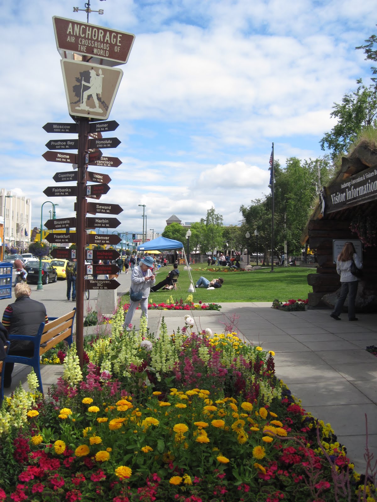
Given the many miles we had to reach Alaska and the bumpy roads, John and I started thinking that perhaps we should have instead flown into Anchorage and toured the state from there by car. There also had been the option of taking the ferry through the inside passage and thus cutting off some of the miles. Those thoughts were completely dispelled Saturday when we drove through the northern Canadian Rockies on the Alaska Highway. Almost every bend in the road presented some kind of spectacular mountain vista. If we were not gazing up at towering snow-covered mountain peaks we were looking down vast verdant river valleys. Adding to those picturesque scenes were many rivers which meander for miles through the wilderness.
The highest summit on the Alaska Highway is Summit Pass, located in this stretch of the Canadian Rockies. It has an elevation of 4,250 feet. Below is a picture of Summit Lake located at the pass.
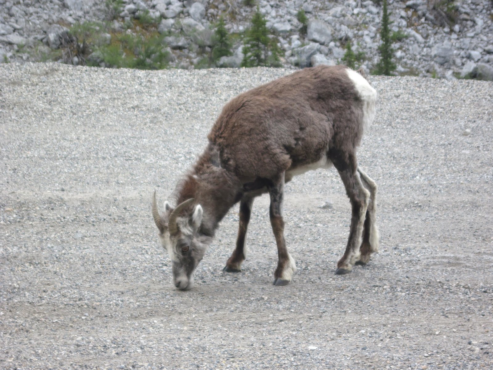
It was thrilling to be surrounded by so many of the different mountain ranges which make up the Canadian Rockies. One group I am fairly familiar with are the Sawtooth Mountains, just not sure where I saw them before. They could be seen very clearly from the highway. Unfortunately I did not get a picture of them. It is not easy to make any kind of a fast stop with our large rig! On the hillsides of the mountains, as well as even on the highway, we saw a lot of wildlife that day. Our first sighting was what I thought were mountain goat. Out tour book for the highway, MILEPOST, identified them as stone sheep. They are indigenous to the mountains of British Columbia and the southern Yukon Territory. The sheep are interesting looking creatures. They have fine gray strands of hair which hang down the sides of their faces.
Another animal we were surprised to see on the highway was bison (we found out later that the bison here are woods bison, not the plains bison which we are familiar with). In one area there were so many of them that it necessitated  flashing signs along the road warning of their presence.
 The other animal which we saw from the highway that day was black bear, a total of three in different areas. We reached Watson Lake in the Yukon Territory about 7PM and parked there for the night. We had encountered brief rain showers with strong winds toward the end of our journey that day, but fortunately for us those last miles at least has some fairly smooth road!


T

Saturday, June 12, 2010

Fort Nelson, British Columbia

We did not make it to the Yukon Territory, as you may notice by the title of this posting. And we may not make it tomorrow. We have about 327 miles yet to go from here to the border. Our drive on the Alaskan Highway was slow today. There were a few high hills to climb and steep grades to go down. There was one patch of road where we had to laugh at all the warnings. At that spot there were signs warning about moose on the road, icy conditions, 8% grade, and, if that was not enough, we were warned that the road was uneven. We soon learned  to take that latter warning seriously. John took the first rough wave of road  a bit too fast and I thought every dish in my cupboards would be broken. Fortunately our motor home stayed in one piece and no dishes got smashed. Most of  what we saw today was lots of rolling hills and forest. The picture below was taken from the top of a hill just before we started descending into a river gorge. Only the tops of trees can be seen.
 The river canyons provided some awesome scenery with their steep rocky bluffs. Below is a picture of Chief Sikanni River. This river flows eventually into the Mackenzie River which empties into the Arctic Ocean.
It amazes me as to how far north we are and what that means for the climate in this area during the winter. According to The Milepost (Alaska's travel planner) Dawson Creek has 100 frost free days. And that certainly accounts for the miles of roadway without any sight of bill boards, homes- any sign of life other than the millions of bugs which cover our windshield and deer by the road!  In a way it is refreshing to only see wilderness surrounding me for miles and miles. Today we saw one large farm complex, and one small town between Dawson Creek and Fort Nelson. It certainly is a different way of life up here. The summer evenings also take a bit of getting use to. I noticed last evening that it was still dusk at 10:30 PM. That makes it hard to figure out when to go to bed. Eventually just feeling very tired makes that decision easy.

Friday, June 11, 2010

Highway 97 to the Alaskan Highway

Wednesday we continued to drive north, up and down hills. The scenery remained quite beautiful with mountain lakes and forests. In that section of British Columbia we saw a few warning signs along the highway for badger crossings. However, we never saw one of those critters crossing the road. That night found us at Dragon Lake, a very quiet and serene place tucked away in the hills near the town of Quesnel.  Many older folks were there for the fishing, and probably the peacefulness of it all.
Like last summer we are seeing very little of the tourist crowd. People on the roads are mainly retried folk like John and I. Occasionally we see another vehicle from the states, but people parked in the recreational areas are now mainly from British Columbia. The park in Quesnel also had some beautiful gardens. In the picture below you may notice spring flowers as the iris and bleeding hearts. Spring is starting here in the north country. That is the lake again in the background.
And how about this old man enjoying his book in the garden? Quite an interesting piece of sculpture!
Yesterday found us again on highway 97, crossing the continental divide and the western edge of the Canadian Rockies.  Small lakes and waterfalls completed the vast mountain vistas. We even spotted a black bear up in the hills. It all seemed to give us a feeling of being in pristine wilderness.
The beautiful landscape abruptly changed further down the road as we  came near the town of Dawson Creek. The land became flatter, dusty and dry. We are now on the eastern side of the mountains which has the rain shadow effect. And we are also at mile zero of Highway 97. From this point on, at Dawson Creek, we will be on the Alaskan Highway. It certainly has been slow going, what with climbing mountains and sitting at construction sites along the way. We are still making some progress, however, in our drive north. Hopefully we will get through British Columbia today and into the Yukon Territory.

Wednesday, June 9, 2010

Kamloops British Columbia

So far so good with my internet connections, which is why I am continuing to write postings. Last night while John and I were walking around on the rodeo grounds we noticed large wooden horseshoes hanging on posts with famous rodeo performer's names and their awards listed on them. Some were noted for calf roping, others for bronco riding, others for the suicide race, and so forth. We wondered what the suicide race was all about. We got into a conversation about the rodeo with our neighbor in the park from British Columbia (who says he comes to Omak frequently for gaming at the local casino and for cheap shopping). He informed us that once a year, in July, there is the famous Omak stampede. That is the suicide race. He pointed to a path coming down the hill near us which ends in the river. That is where the suicide race takes place. Seemed to me that at the top of the hill, where the path started, there is a subdivision. Guess that is not stopping the stampede!
Today we crossed the border into British Columbia. The scenery has been awesome, to some extent a bit like what we saw yesterday. We did a lot of driving over hills and down into valleys. Our route has been following the Okagan River.There have been many more glacial lakes also. In the fertile river valleys we saw numerous cherry and peach orchards, also vineyards.There have been lots of rolling and rugged rocky hills. And, as we drive further north, we can view mountains off in the distance. We are also starting to see more pine forests and less of the arid hills. Below is a picture of the hills which surround our campground. 
 

Tuesday, June 8, 2010

Northern Washington

Most of our drive north  from Walla Walla was through agricultural land. There were many green rolling hills, the likes of which we had seen Saturday on our drive to Palouse Falls. We passed by numerous orchards, many of which seemed to be apple. We also saw many cattle in feed lots. I told John that I thought that they looked depressed all crowded together in muddy pens! Then, similarly as our experience was Saturday, we started climbing into higher elevations and started seeing land that was arid and rocky. Only a few towns dotted the landscape now and we saw signs pointing to such recreational areas as Moses and Soap Lake. There was a rest stop right alongside of Blue Lake where we stopped for a break and to snap some pictures.
The above picture was taken from the road looking up at the rocky walls surrounding the lake. Below is a picture of the lake itself.
 Our next stop was the site of the site of the "greatest waterless falls in the world". Back in the time of the glacial meltdown the water which fell over the falls here equaled ten times the volume of all the rivers in the world. It flowed through what is now eastern Washington, through the Columbia River Gorge and into the ocean at an estimated speed of 60miles per hour. The strong flow of water filled with mud and silt sculpted steep walled canyons  as well as immense water falls. Thus came about the creation of such places as Palouse Falls and Beacon Rock. In the picture below you can see where the chute was as the water flowed into the plunge pool below it.
 And below is a picture of the lake which formed in the coulee. The falls did not continue to have a river source as the Palouse Falls still has today so it became waterless.
We parked for the night in the town of Omak.,which is fifty miles this side of the Canadian border. There is an recreational vehicle park there on the rodeo grounds. The town itself is located along the Okagan River. Last evening we walked on the levy into town and were surprised to find two old movie houses still in operation. It was not in our plans but we saw the movie Killers starring Ashton Kutcher and Tom Selleck. That is the fun of traveling, we just never know completely what is around the corner.