Sunday, June 30, 2013

The Wilds of Wyoming

We had a most interesting day yesterday and it did not end well, as we nearly got swallowed up in the back country of Wyoming!  More on that later.  North of Rock Springs is a corral for wild horses.  Outside of the coral is a shelter whereby visitors can view them and also receive information regarding the horses presence in the West and how to adopt them.  There are over 40,000 free-roaming horses and burros through out western states, and over 200 herd management areas administered primarily by the Bureau of Land Management.  When the herds increase and there is limited vegetation and water to sustain the animals it then becomes necessary for the BLM to round them up.  The horses are descendants of the horses brought over by Spanish explorers in the 16th century, so technically they are described as feral.  Many people refer to them as mustangs, which is Americanized slang for the Spanish word mesteno, or "stray".
 
After viewing the horses John and I drove further north into Wyoming on Highway 191 to look at the White Mountain Petroglyphs.  To get to them it was necessary to drive on an "improved dirt road".  We had to drive 17 miles on that road, and then hike a short distance across desert-like scrub land to see the Indian drawings on a large sandstone formation ( we could not miss it, it was the only large hill for miles around). 
One panel of the petroglyphs is pictured above.  It is of some antlered animal, other pictures depict buffalo, and human stick figures.  Possibly in the above picture there is also a boar below the deer or elk.  Anthropologists estimate that the drawings were done about 200 to as much as 1,000 years ago.
We traveled further on the dirt road, following signs to the sand dunes, pictured above.  The dunes may reach as 100 feet high, and are over 70 miles long.  The last must-see on John's list was the Boar's Tusk.
This rock formation, which holds great religious importance to Native Americans in the area, rises 400 feet off the desert floor.  It is a core of an ancient volcano.  Returning to Rock Springs, John decided to take a short-cut back to town, our first mistake.  Shortly after that we got into a hard rain, and had trouble seeing the road.  The road came to a fork- we took the higher road thinking we were better off on high ground.  That was our next mistake as it was a sand-pack road into which our tires rapidly sank.  We called AAA, and were told that there was only one tow truck in the area and the driver was not answering his phone.  We tried digging ourselves out with a frisbee, a garden trowel and John's walking stick.  I have not had my hand in so much sand since my childhood!  It was cool and moist, I did not mind ( I found out later however, once I washed my hands, that it was quite dirty).  Eventually we just sat in the car, we were fortunate that the rain brought the desert temperature down.  We had food and lots of water- and I had a book.  We sat for several hours until a man and his family came along.  They were in a camper truck and towed a trailer which held their dune buggy.  They also had a nice chain which could be attached to the tow bar of our car.  It was amazing how easy it was then for our car to rise up and over the packed sand piles!  We were able to get back on the dirt road and arrived safely home after that.  I fear that we did some damage to the under-carriage of the car,  it dropped chunks of rock and sand all the way home and occasionally would make some weird noise.  John thinks the noise is from the muffler.  That was our fun day in the desert, hopefully not to be repeated again for a long time!

Saturday, June 29, 2013

Red Canyon and Flaming Gorge Dam

This is continuing our story of the trip we made Friday on the Flaming Gorge-Uinta National Scenic Byway (US 191).  It traverses over an area which exposes billions of years of earth's history, an area replete with fossils and geological features.  Signs along the road mark each ancient era as: "Jurassic period, alabaster formations and ancient tidal flats".   John and I certainly did not do it justice trying to see it all in one day.
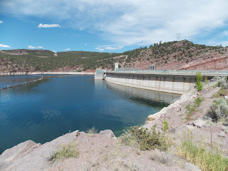
I mentioned Red Canyon in the last posting, it is pictured above.  John commented that had the river level been higher, it could be about as impressive as the Grand Canyon.  It is a beautiful sight, and one in which the picture does not completely capture all of its beauty.  Wildlife abounds in this area; bear, elk, moose, bighorn sheep and mountain lions have been seen.  We saw flying overhead golden eagles and osprey, feeding off trout and salmon in the rivers flowing through the canyon.  We took in a tour of Flaming Gorge Dam,  from the top of it we could see very large trout in the waters below.  The dam is pictured below.
It is no wonder the fish are so large, on every dam tour visitors are encouraged to feed the fish!  And another little critter has learned to take advantage of that.  While we were tossing food to the trout a young yellow-bellied marmot came close to us and begged to be fed.
A 91-mile long reservoir on the Green River was created by the dam in the early 1960s.  President Kennedy flipped the switch for the first generator to start in 1963, it was dedicated by former First Lady Bird Johnson a year later.  There is enough power produced from the Flaming Gorge Power Plant to serve 6 states.  Pictured below is the spillway of the dam, over flow water is channeled down a tunnel inside the mountain.  Highway US 191 can be seen above the spillway.  Also note that the Green River is really Green!


Flaming Gorge, Utah

We arrived in Rock Springs on Thursday.  Once the heat of the day had abated, we drove into the historic center of town.  In  a small park near the above sign we learned the history of the area.  We immediately walked to a statue of a miner and his horse pulling a load of coal.  Buried under the streets of the town are seams of coal.  In 1868, once the Union Pacific Railroad came through Rock Springs, then the commercial mines were opened.  The town became known as the "Newcastle of the West".  In the 1950s the underground mining stopped and in the 1970s strip mining began.  Mining has been the economic mainstay of this region, but there has been a sobering reminder of the price it had to pay, as with all mining ventures.   In the park we found a memorial with the names of all the men killed in the mines over the years.
We are now parked in Wyoming, near the Utah border.  The picture above gives you an idea of the land which surrounds our home- low-lying grey hills with sparse vegetation.  Yesterday we drove south into Utah and, once we drove over the border a different sight greeted us.

John Powell was the first scientific explorer to journey down and document his findings along the Green and Colorado Rivers in northeast Utah.  The Green River, he says, "enters the range by the flaring brilliant red gorge.  We name it Flaming Gorge."  The range he was referring to was the Uinta Mountain Range, the only major mountain range in the lower states with an east-west alignment.  The gorge and rivers are located within the Ashely National Forest.  It is this area we which we explored yesterday, a beautiful land of forests, deep canyons and rivers.  We also finally saw some bighorn sheep, apparently they like to hang around the visitor's center of Red Canyon.  Pictured below is a yearling male.  As he and another ram tried to flee from us they quickly leaped over a fence and bounded down over the rocky ledges of the canyon, it was amazing to watch how agile the sheep are!   I will have more on that canyon in my next posting.


Thursday, June 27, 2013

Cache La Poudre Scenic Byway

Our last day in Colorado, Tuesday, found John and I on beautiful Colorado Highway 14 from Fort Collins to Cameron Pass.  We saw everything on this drive;  from the spectacular Poudre Canyon, and rushing Poudre River, to vast forests and mountain meadows to high snow-capped mountain peaks.  Guess I should just start from the beginning, when the road followed the meandering river for quite some distance.  The Poudre River offers some of the best white water rafting in Colorado, and we saw many rafters putting into the river.
It could not have been a more perfect day to be out on the river!  The river is also one of the West's finest trout streams.   And this was one drive when we really felt like we were in a canyon- towering massive stone walls arose up on both sides of the highway.
Looks like one massive sheer wall, right?  But the road does go right in-between the rock!  About 50 miles up the canyon the road drops over 10,000 foot Cameron Pass.
We were told by a couple running the Visitor's Center to look for moose in this area, and we found a bull.
The highlight of this trip for me was a mountain meadow splashed with the brilliant yellow of buttercups and arnica, a type of daisy.  It is pictured below.  Well, there was another good moment for me when, while hiking around the Wright Reservoir, I found a patch of the delicate yellow glacier lily.


Wednesday, June 26, 2013

Mount Evans

We had plans to take a day trip to Rocky Mountain National Park, but our son Mike was adamant about seeing Mount Evans.  His cousin Katie and her boyfriend had been there last week and it seemed to fit his criteria as a mountain to visit.  John and I had no compunctions either way, and if we joined our son, we would be able to spend more time with him.  So on Monday we drove south to Denver, and then west along the Interstate 70 corridor.  At the entrance gate to the Mount Evans Recreation Area in the Arapaho National Forest a sign greeted us with the information that the current temperature was 64 degrees, at the summit it was 42 with a wind chill of 35 degrees. We were ready with our jackets! The road up the mountain is the highest paved one in North America, taking us from pine forests to snow-covered mountain peaks.  Our first stop on our way up the mountain was at Summit Lake, designated a National Natural Landmark in 1965 because of its extraordinary characteristics.  It is located in the alpine, but the environment mirrors the Arctic Circle.  Rare plants found at Summit Lake are usually found above the Arctic Circle, and permanently frozen ground unique to the dry alpine tundra is present.  The lake, at12,830 feet elevation, is pictured below.
As I walked along the lake I espied some white flowers- I discovered later that they were white mountain avens, a flower which grows above the timberline. They stood out from all the grey surrounding them.
 Mike wanted to see mountain goats-we saw some grazing and the babies frolicking near the summit parking lot. Another animal which we saw zipping under and around the rocks were marmots.
 
  From the parking lot there is a quarter mile trail to the summit.   It was a bit rocky and muddy from melting snow, but getting to the top was worth it.  Our final elevation was 14,130 feet.  Of course, Mike had to check out his phone reception!  An interpretive sign there informed us that from the top we could see most of the Continental Divide in Colorado, as well as Denver, Long's Peak and Pikes Peak.  It sure helped that we picked a clear day- our visibility was great at the top.
 On our way down we took some time at Mount Goliath Natural Area.  Here there are forests of the bristlecone pine.  According to a park brochure "These remarkable trees are the oldest single living organism on earth, capable of living for thousands years".  Many have severely twisted trunks, their adaptation to extreme winds. 


Tuesday, June 25, 2013

Mountain Top Highs

As I had mentioned in previous postings, John and I came to Fort Collins for our niece Heather's wedding.  Consequently the last few days have been filled with visiting family who have come from many parts of our nation for the event.  The setting for the wedding was on the lawn of an old Victorian ranch house, colorful gardens surround the building called the Tapestry House.  Pictured below are the happy parents with the beaming couple.  Ann's parents are from San Francisco.  Heather and Anne live in Denver, Ann is planning to enter law school this fall.  It was quite a momentous event, with over 100 family and friends in attendance.
On Sunday we were able to spend what precious time we had left with our children, Melissa and her husband Spencer as well as our son Mike.  Melissa had been in the wedding party so we had very little time to spend with her over the week-end.  She and Spencer flew back to Virginia that afternoon.  After all the festivities were over John and I were ready to do some hiking.  My sister Gloria, her husband Chuck and Mike were willing to join us, it also allowed us to get in some visiting time with them.
In the picture above all, except John, are taking in the wonderful vistas offered by Horsetooth Rock.   The large hill is located in the foothills west of Fort Collins.  According to local legend, the mountain is the remains of an evil giant's heart cut in two by a powerful Indian chief, thus protecting his people from the giant's wrath.  The foothills trail skirt around Horsetooth Reservoir.  Beautiful red-stone cliffs flank the 6.5 mile lake, it was an awesome hike under the late afternoon sun.  The sun was setting by the time we completed our hike.  On Monday our plan was to see Mount Evans, more on that in the next posting.

Saturday, June 22, 2013

Fort Collins, Colorado

As the name implies, Fort Collins was once an army garrison.  After the American Indian conflicts of the 1860s had ended, the army abandoned the post.  Fort Collins then became a town initially economically aided by the Overland Trail, as well as local farms and ranches.  Today it is an industrial, technological and education center (University of Colorado).   As usual, John had done his research on the town and determined that the area we should check out was the historic Fort Collins.  
It is an area of wide streets,  small parks, shops, sculptures and fountains. There are also pubs, restaurants and a small stage for entertainment venues.  Serving as a backdrop are large Victorian-styled sandstone buildings built in the 1800s.  Perhaps it is those buildings which Walt Disney modeled his Main Street after in his Disneyland Parks.  I am not sure about that, as many years have passed since Disneyland was built and this older section of Fort Collins was revitalized in 1985.
In the lower right-hand picture of you may see a colorfully decorated piano, one of several in this two block area.  Usually when we found one, someone was on the piano bench and plunking out a few notes. Fort Collins seems to be an economically vibrant college town.  The shops are quite varied; appliance, auto upholstery, spice, books, fossils and gems. Any number of the tourists favorites can also be found;  ice cream, cookies, cupcakes and fudge.  I will also always remember this as a town of bicyclists, hikers and panhandlers- and practically everyone has a backpack behind them.  Many of them look as if they just came in from hiking the Rockies.  Perhaps students from the university never went home for the summer, instead they are working in Fort Collins and spending their free time in the hills.

Gardens on Spring Creek- Fort Collins,Colorado

Wow!  First day of summer and we are still seeing spring flowers here in Fort Collins.  However, we are certainly getting summer temperatures- as you can see from the sign above, the average temp should be in the low eighties for June, but they have been closer to ninety degrees since we arrived Wednesday.  Yesterday, Thursday, we toured the Gardens on Spring Creek before checking out the historic area of Fort Collins.  The sidewalk sign pictured above is one of 12 which can be found in the gardens, one for each month of the year.  I did not realize so many names had been applied to moons-  for June it is a strawberry moon and, if I remember correctly, March's moon is the worm moon.  Maybe more information on the moon names can be found in the Farmers Almanac.  The Gardens on Spring Creek are interesting on several levels, first that they are easily accessed by the Spring Creek Bike Trail.  Secondly, The Children's Garden is an interesting place with many fun interactive things for kids to do.  A day camp was there when we visited the gardens and it seemed that many of the children were enjoying the watering can pictured below- it requires someone pumping the water up out of a well  before the water flow out of the sculpture.
The third most interesting thing about the park is that it gives its produce to a local food pantry.  A section of the gardens is called "Good Eatin'".  It is a three-quarter garden which promotes sustainable methods of edible gardening.  I was especially impressed that in this area there is a strawberry bed, as well as raspberry, gooseberry and elderberry bushes.  The latter shrub is blooming now, and is pictured below.  The shrub has such a wonderful fragrance and I assumed it was a lilac bush, but a garden intern working in the area informed me that it was an elderberry bush.
The rock garden features native and adapted plants as well as dwarf conifers native to the Rocky Mountains.  Plants are displayed among quarried rock formations which are arranged to reflect the natural rock formations of Northern Colorado.  That part of the garden is pictured below, it is quite beautiful at present with blooming columbine and penstemons.  The next area which we toured on Thursday was the historic part of Fort Collins, more on that later.

Wednesday, June 19, 2013

Lead and Spearfish, South Dakota

After visiting Deadwood we traveled further into the Black Hills to see these two towns.  It was my original intention to write about our day in one posting but I just had too many pictures to share with you our readers.  The scenery which we saw Monday is probably the prettiest to be found in the Black Hills.  We drove southwest from Deadwood to Lead.  Founded with the great gold rush of 1876 it soon became destined to be one of the deepest, longest operating and most profitable gold mine in the Western Hemisphere.  The site of the original discovery of the Homestake Ledge has long since disappeared into the Lead's open cut ("Lead", pronounced LEED meaning the trend of the gold vein).  Forty million tons of rock has been taken out of what once was a solid mountain.  Total depth of the mine was at 8 thousand feet.  The mine ceased operating in 2002 after producing in excess of 40 million ounces of gold.
A museum stands next to the site, and in the bowels of the mine is now the Sanford Underground Research Laboratory.  Since the mine's closing scientists have converted it into an underground laboratory where physics experiments can be conducted.  The laboratory needs to be deep underground to avoid cosmic radiation.  From Lead we took Spearfish Canyon Scenic Highway, which follows a clear meandering mountain stream.  Towering cliffs and ponderosa pines continued to surround us,  if you are looking for a paradise on earth this does come close to that ideal.  When we reached Roughlock Falls an interpretive sign near them captured my musing thoughts exactly:  "Spearfish Canyon showcases paradise".
Along the scenic highway we saw signs for several waterfalls, however, it was getting late in the day and we only had time to hike into Roughlock Falls.  The name dates back to the 1870s when wagons traveling through the canyon's deep ravines had to deal with excessive speed going downhill.  The drivers had to chain or log their wheels, which then allowed the wagons to slowly skid down the slopes.


Tuesday, June 18, 2013

Deadwood, South Dakota

Some of our family may be wondering what we are still doing in the Black Hills when we need to be at Heather's wedding by Saturday.  Well, for one thing I am a day behind in my postings, and secondly we did leave for Fort Collins, Colorado today and are currently residing in Wyoming.  As we drove into Cheyenne, on Interstate 25 we passed by two pronghorn grazing close to the highway.  I was so tempted to have John stop our rig and try to get them to go over the fence and back to wherever they came from, but common sense stopped me.  Surely the local people know how to deal with that situation!  I did question the owner of the rv park where we stopped for the night about the antelope.  He asserted that for some reason there are not all that many accidents with the pronghorn.  He also said, with a grin, that they are known around here as "speed goats".  They are more goat than antelope, and belong to that family.  Also, according to him, they do not have the muscles to go over fences, but under them.  Well, I did promise to write about Deadwood, once known as Deadwood Gulch by the early miners.  They noticed many dead trees around their camps and so named it Deadwood.  The town is totally surrounded by the Black Hills, quite a beautiful setting, and does not deserve its name!  The second building in the picture below is the old courthouse.
 Deadwood was first settled in 1876, by miners hoping to strike it rich by panning for gold.  It very soon became the commercial center for the Black Hills.  The town's prosperity was  linked to and stimulated by its advance mining technology.  Also in its first year the postal service, stagecoach and telegraph came to the town.  They were followed by the railroad which brought in the equipment for the first saw mill and ore processing plant.  One of the old mine buildings is pictured below- it is the slime processing plant of the Homestake Gold Company.  Now it is a hotel and casino as well as an antique mall.
In its early years Deadwood gained the reputation as "the wickedest camp on earth".  John and I had picked up a map which provided us with a walking tour of the town, and we first went to what once was called the  Badlands.  It is an area of Deadwood populated in the 19th century with brothels, gambling halls and opium houses.  On August 2,1876 in Saloon Number 10 on this street Wild Bill Hickok was shot in the head.
He slumped forward and out of his hand fell black aces and eights, which has been forever more since then been called "a dead man's hand".  In 1879 a fire swept through the town and destroyed 300 of its wooden buildings, followed by other fires in 1982 and 1987.  Major flooding has also occurred in Deadwood over the years so that many of the buildings are only replicas of what once stood there.  A sign at Saloon Number 10 notes that it is the "site" where the  "Prince of Pistoleers" died at the age of  39 years.  After touring Deadwood we drove to Moriah Cemetery where Hickok is buried.  Near his monument (pictured below) is also where Calamity Jane (1850?-1903) is buried.  Her dying wish was to be buried next to Wild Bill, as she claimed to be his lover- supposedly not true.  We found buried near her Dora Dufran, a much beloved madam and owner of many brothels.  She befriended Martha Canary (Calamity Jane).  We discovered our walk through the cemetery to be as fascinating as our tour of Deadwood.  There are several potters fields there, as well as sections where the more notable citizens of the town are buried; successful business and mining men as well as statesman, editors, publishers and South Dakota's first woman lawyer.

Hot Springs, South Dakota

We were in this area about 25 years ago, and it was at the time of the annual motorcycle rally in Sturgis.  Literally the roads were dotted with black bikes.  My memory of this area this time will be of hundreds of green and yellow army trucks.  Apparently at present troops are in the area (not only from all our states but from around the world) for combat training sessions.  While in Custer State Park we saw their tent sites.  From Custer and Wind Cave Parks we drove to Hot Springs and the Mammoth Site.
 Also when we were here years ago we saw the Mammoth Site.  Then it was about 10 years old and not the large research and education site it is today.  This time we had a guide take us around the site who pointed out different areas where the bones are lying in-situ (in place).
In 1974 a bulldozer operator was preparing this site for an housing project when he noticed a tusk in the dirt.  Since then the remains of 60 mammoths have been found, and other extinct animals.  Scientists believe that about 26 thousand years ago this area was the site of a spring-fed sink hole which apparently was quite deep with slippery slopes  around it.  Mammoths and other animals, once they fell into it, had no hope of getting out.  There are enough bones at this site that, during the July digging fields session, keeps the workers busy for a full year preserving, identifying, sorting and cataloging the bones.  After touring this museum we drove into Hot Springs for supper.  The town is quite pretty with a river running through it and a waterfalls.
Also, as you may notice in the picture above, it is a town surrounded by towering reddish-colored cliffs.  And reportedly 127 thermal springs have been found in this area, over the years it has been a favorite vacation spot for those people seeking its warm healing waters.  The town is also remarkable for its turn-of- the century( twentieth century) sandstone buildings.   This wraps up our story of last Saturday.  Interestingly enough, we started it and ended it with buffalo.  I had a bison burger for supper, it tastes like beef, but is much leaner and probably better for me.  We had see one buffalo ranch out here, but it would be nice if there were more!  I would imagine, however, that they are not easy to raise compared to cattle.


Monday, June 17, 2013

Back to the Blackhills

It is the peak of springtime here; lilacs, iris and many wildflowers are blooming. Hard to imagine we started seeing spring a couple of months ago in Texas!  On Saturday, just outside of  Custer State Park, we were treated to the sight of a field of purple wildflowers, unfortunately I never found out what they were!
 
In the park we drove on the Wildlife Loop road, hoping perhaps to get a glimpse of some bison, deer, or elk.  We saw many herds of buffalo, which at this time of year are calving.  The park keeps an average of 1500 head of North American bison.  Each year during roundup the size and the structure of the herd is adjusted according to predicted availability of grassland forage.
We also saw a pronghorn with her baby.  Pronghorn are commonly  referred to as antelope, but the true antelope are in Africa.  Pronghorn are the fastest land animal in North America.
 
 Also, it was exciting for us to see a buck- which we have never seen before.  The proonghorn was so named because of his his large pronged horns. 
Our next stop on Saturday was at Wind Cave National Park.  John and I have toured many caves, but John wanted to see this particular cave because it is known for having the most boxwork formations of any known cave.  This is a criss-cross pattern of thin crystalline fins projecting from the ceilings, giving the appearance of honeycombs or post-office boxes.  The cave is mostly dry and contains very few formations built by dripping water such as stalactites or stalagmites.
The cave was discovered in 1881 by a man who felt a blast of cold air flowing out of the earth- it was strong enough to blow his hat off.  Wind Cave was so named for the natural breezes which blow in and out of the entrance. Winds of more than 70 mph have been clocked in the walk-in entrance, we also could hear the wind blowing through the cave as the door was opened.  We put in a long day on Saturday and I have more to share with you,  I will complete that story in my next posting.

Sunday, June 16, 2013

Flora and Fauna in the Badlands

We stopped at the Sage Creek Basin overlook in the Badlands, and, after stepping out of the car, soon heard the songs of many birds.  According to park information, bluebirds, waxwings, sparrows robins and other birds like to perch and nest in the juniper grove- which is pictured below.  The berries of the tree are quite tasty ( supposedly they have a gin flavoring) and provide sustenance for the winged creatures.
 
 In the foreground of the picture above notice the prairie grasses.  Badlands prairie contains 60 species of grasses which are able to withstand high winds, frequent fires, and spells of dry weather.  Grazing animals as antelope, bison, muledeer and pronghorn antelopes are abundant on the prairie.
 
Driving through the Badlands we did see several pronghorn.  John tapped lightly on the car horn to get them to look up and pose for us.  As you can see in the picture above we did get one of the antelope to look up- his erect ears indicate that he senses danger and is ready to bolt.  Also out in the prairie of the Badlands we came upon a prairie dog colony.  When they sense danger they scurry to their homes underground but, before burrowing,  may stand up and yip or wag their tails to warn the rest of the colony.  The one pictured below seemed to have had no sense of any danger in our presence.  Maybe he is just taking in the sun and the many wildflowers which surround him.
That about wraps up our day in the Badlands, except that I have one more picture to post here.  Our last stop in the park was to hike around of a the rim of an ancient volcanic caldera,  pictured below.