Sunday, June 20, 2010

Palmer Alaska

The visitor center at Palmer has quite a beautiful garden. A lot of spring flowers are blooming, and some of the summer flowers also seem to have gotten a good start. Below is a picture of a scotch rose shrub which is located in a corner of that garden. I has a very beautiful and fragrant flower.
Palmer is known for its vegetables which grow quite large, maybe the same magic works for the flowers. The town is the only Alaskan community that developed primarily from an agricultural community. The growing season averages 100 to 118 days a year with long hours of sunshine. At the visitor center we saw a film which presented the story of the Matanuska Valley Colony. In 1935 the town became the site of one of the most unusual experiments in American history. The Federal Emergency Relief Administration, one of the many New Deal relief agencies created during Franklin Roosevelt's first year in office, planned an agricultural colony in Palmer.  Families were chosen from Michigan, Wisconsin and Minnesota, 203 of them all total. Those families arrived in May 1935 and had only three months to get roofs over their heads and crops planted. Each family was given 40 acres and a loan of $3,000. The failure rate was high, and many of the families returned to their home states. The long cold winter months took its toll as well as disease. At the time the colony was getting started, the religious care of the colonists was assigned to the Presbyterian Church. A log church was 1936 and additions to it have been built since. It is known as "Church of a Thousand Trees". While touring the town we stopped at the church. The wood interior is quite beautiful, and  conveyed to me a feeling of peace and warmth. We plan to worship there tomorrow. When I took this picture people were starting to gather in the church for a wedding.

Saturday, June 19, 2010

Glenn Highway to Anchorage

The Glenn Highway is what we turned onto from the Alaskan Highway to reach our final destination of Anchorage. It is a scenic road with many mountain vistas and, most importantly, glaciers. A little fact which I learned yesterday is that glaciers all over the world cover 30,000 miles, of which the majority are in Alaska. Also 75% of the world's fresh water comes from glaciers. Yesterday we had the privilege of viewing their beauty.  The best way to show you some of the spectacular sights we saw yesterday is just to post some pictures here. How about this for a sight to look at while eating lunch?
After lunch we were back on the road again. Soon the highway descended into a long straightaway toward  an large oddly formed rock formation with a dome on its top. According to MILEPOST  tour book this rock is called Lion's Head.  It marks the area of Glacier Point where a glacier comes down from a mountain toward the Lion's Head. Again, a picture best shows this beautiful view.
Lion's Head is off to the right and the glacier is coming down off the mountain in the distance on the left. While we were standing there we noticed a man with a binoculars looking up a mountainside across the street. He pointed out to us Dall Sheep grazing up on the hillside. It was fascinating to watch them move with agility from one rocky ledge to another. Even the very young ones seemed to be very surefooted. We were able to come  closer to the next glacier we visited, called the Matanuska Glacier. There was a park off the highway from which we could view it, and also a trail which took us through a boreal forest to viewing platforms.
What an awesome chunk of ice! The glacier is two miles in width and at its terminus it is 4 miles wide. The glacier has remained fairly stable for the past four hundred years. Some 18,000 years ago it reached all the way to the Palmer area. The town of Palmer is where we are going to stay for a week. We are meeting up there with my brother Wayne and wife Mary Jo. Palmer is about 50 miles east of Anchorage. It will be great to be parked in one spot for awhile.

Thursday, June 17, 2010

Alaska

The last two days have been rough going what with bad roads and many construction sites. As you can see from the welcome sign above, we did make it to Alaska today. The roads are getting to be a bit better, but still not the greatest. Yesterday we again went through some very scenic mountainous areas which included the St.Elias Mountains. In that range is the highest mountain in Canada. Also in that area is  the largest non-polar ice fields in North America, which extends over most of the Kulane National Park and Reserve.
The picture below is that of Kluane Lake which sits in that mountainous valley.
Something else which I found to be quite beautiful yesterday were the lupines growing along the highway. They looked like huge purple bouquets of flowrs springing up out of the gravel. It sure speaks to the hardiness of that plant!
Last night we parked in a campground owned by two couples from England. They have a lot of work to do there. Many pieces of old machinery are scattered around their place, probably left when the construction of the highway was completed in the 1940s. It is a remote campground with mountains surrounding it and the White River flowing nearby. Very picturesque and beautiful, I enjoyed hiking along the river last evening. As I said before, it is hard to go to bed when dusk is at 11:30 PM!  Thought for sure I would see a moose or two when I was out walking last evening, but I did not see any. This morning we spotted a big bull moose along the highway shortly after we started out. He sure headed fast back into the forest when we drove by!

Wednesday, June 16, 2010

Whitehorse Yukon Territory

We reached Whitehorse on Monday. Whitehorse is the capital of the Yukon Territory, and a city of 25,000 people. It has many historic things to see here so we decided to stay over one day to see them. We started our day in Miles Canyon,  thinking we would take a short hike to see the gorge of the Yukon River. In our initial view of the canyon we saw an interesting example of what is called columnar jointing. The lava walls look like bundles of straight posts. Above the walls is a suspension bridge which we crossed to start our hike.
 
That little hike turned out to be at least a couple of miles because we decided that while at the canyon it would be great to see the location of the now abandoned site of Canyon city. Before a dam was built in this area the rapids of the river were too strong for the gold miners to traverse in their boats. It was necessary at Canyon city to go on shore and load their supplies on carts. From there they would  travel over land for part of their journey to the gold fields. We did a bit of strenuous hiking up and down the river bluffs to find that site. All that is there now are two carts and a midden of tin cans which are probably 100 years old.
From the canyon we drove into the town of Whitehorse. We stopped at the S.S.Klondike, one of the largest sternwheelers to ply the Yukon River from 1929-55. We got in on a very interesting guided tour of the boat.
 
The town is surrounded by three mountain ranges. Initially it was only boats which could get into the area. After our tour of the boat we went over to an old log church which was the first Anglican mission in the town and now houses a museum. How about this caribou chasuble?  I bet it was warm!

Tuesday, June 15, 2010

Watson Lake Yukon Territory

John and I decided to take a day off from traveling and spend a day in Watson Lake. It was Sunday and we wanted to attend services as well as get our laundry done. I had the erroneous idea that since this town was the only one for miles around, we would have a fairly good choice of churches to attend as well as places to shop. I was so wrong! But that was all right, we still enjoyed our time in this town. We attended services at Laird Evangelical Free church.  The church was built in 1942, most likely at the time of the construction of the Alaska highway. The building is also serves as a community center. It  does seem that quite often when John and I attend services in churches that are not of our faith we find some commonality in the contemporary songs, which was the case in this particular church.
The town has a population of 1,000 people. It was named for Frank Watson who settled here in 1898 with his wife of Kaska First Nation Heritage. He had come north looking for gold. Watson Lake became important during the construction of the Alaskan Highway. Watson Lake Signpost Forest, located at the north end of the town, was started by a homesick U.S. army soldier working on the highway. He erected a  mileage signpost for his hometown and through the ensuing years people have added their own names and places of origin. At the latest count there are 6,000 signs of various sorts identifying places from around the world. It is quite awesome to see. Maybe the picture below will give you an idea of what this park looks like. Of course right away we looked for our hometown.
After church we headed to a small diner for lunch and there we had the most delicious carrot lentil soup. Nearby this diner is the local department store. It really has everything that one would ever need!
 For our Sunday evening entertainment we went to the Northern Lights Centre. There we took in a movie of  the very intriguing phenomena of the aurora borealis.Those crackling lights in the night sky, in all colors of the rainbow, are quite beautiful. It would be great to see the real thing but probably will never happen for John and I as we are not going to be up here in the cold of winter when they occur.

Canadian Rockies


Given the many miles we had to reach Alaska and the bumpy roads, John and I started thinking that perhaps we should have instead flown into Anchorage and toured the state from there by car. There also had been the option of taking the ferry through the inside passage and thus cutting off some of the miles. Those thoughts were completely dispelled Saturday when we drove through the northern Canadian Rockies on the Alaska Highway. Almost every bend in the road presented some kind of spectacular mountain vista. If we were not gazing up at towering snow-covered mountain peaks we were looking down vast verdant river valleys. Adding to those picturesque scenes were many rivers which meander for miles through the wilderness.
The highest summit on the Alaska Highway is Summit Pass, located in this stretch of the Canadian Rockies. It has an elevation of 4,250 feet. Below is a picture of Summit Lake located at the pass.
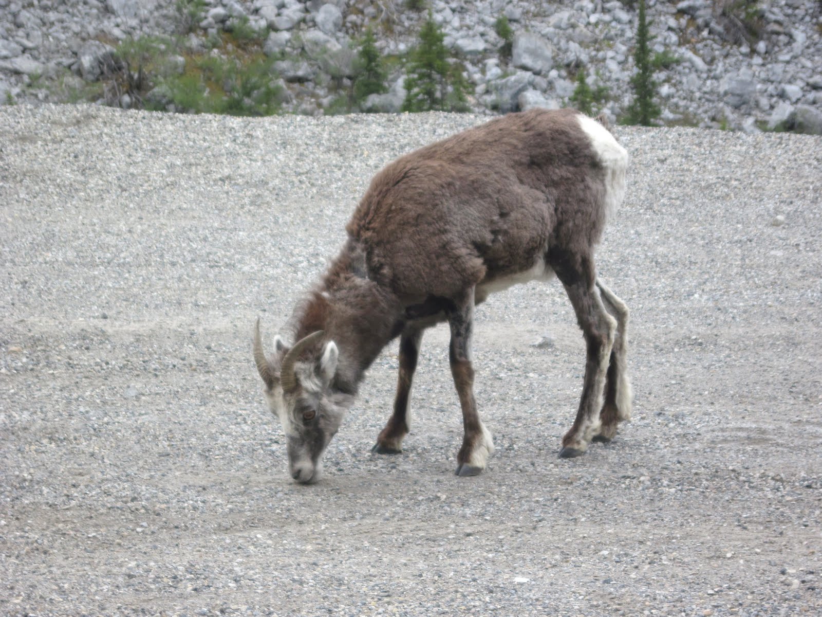
It was thrilling to be surrounded by so many of the different mountain ranges which make up the Canadian Rockies. One group I am fairly familiar with are the Sawtooth Mountains, just not sure where I saw them before. They could be seen very clearly from the highway. Unfortunately I did not get a picture of them. It is not easy to make any kind of a fast stop with our large rig! On the hillsides of the mountains, as well as even on the highway, we saw a lot of wildlife that day. Our first sighting was what I thought were mountain goat. Out tour book for the highway, MILEPOST, identified them as stone sheep. They are indigenous to the mountains of British Columbia and the southern Yukon Territory. The sheep are interesting looking creatures. They have fine gray strands of hair which hang down the sides of their faces.
Another animal we were surprised to see on the highway was bison (we found out later that the bison here are woods bison, not the plains bison which we are familiar with). In one area there were so many of them that it necessitated  flashing signs along the road warning of their presence.
 The other animal which we saw from the highway that day was black bear, a total of three in different areas. We reached Watson Lake in the Yukon Territory about 7PM and parked there for the night. We had encountered brief rain showers with strong winds toward the end of our journey that day, but fortunately for us those last miles at least has some fairly smooth road!


T

Saturday, June 12, 2010

Fort Nelson, British Columbia

We did not make it to the Yukon Territory, as you may notice by the title of this posting. And we may not make it tomorrow. We have about 327 miles yet to go from here to the border. Our drive on the Alaskan Highway was slow today. There were a few high hills to climb and steep grades to go down. There was one patch of road where we had to laugh at all the warnings. At that spot there were signs warning about moose on the road, icy conditions, 8% grade, and, if that was not enough, we were warned that the road was uneven. We soon learned  to take that latter warning seriously. John took the first rough wave of road  a bit too fast and I thought every dish in my cupboards would be broken. Fortunately our motor home stayed in one piece and no dishes got smashed. Most of  what we saw today was lots of rolling hills and forest. The picture below was taken from the top of a hill just before we started descending into a river gorge. Only the tops of trees can be seen.
 The river canyons provided some awesome scenery with their steep rocky bluffs. Below is a picture of Chief Sikanni River. This river flows eventually into the Mackenzie River which empties into the Arctic Ocean.
It amazes me as to how far north we are and what that means for the climate in this area during the winter. According to The Milepost (Alaska's travel planner) Dawson Creek has 100 frost free days. And that certainly accounts for the miles of roadway without any sight of bill boards, homes- any sign of life other than the millions of bugs which cover our windshield and deer by the road!  In a way it is refreshing to only see wilderness surrounding me for miles and miles. Today we saw one large farm complex, and one small town between Dawson Creek and Fort Nelson. It certainly is a different way of life up here. The summer evenings also take a bit of getting use to. I noticed last evening that it was still dusk at 10:30 PM. That makes it hard to figure out when to go to bed. Eventually just feeling very tired makes that decision easy.

Friday, June 11, 2010

Highway 97 to the Alaskan Highway

Wednesday we continued to drive north, up and down hills. The scenery remained quite beautiful with mountain lakes and forests. In that section of British Columbia we saw a few warning signs along the highway for badger crossings. However, we never saw one of those critters crossing the road. That night found us at Dragon Lake, a very quiet and serene place tucked away in the hills near the town of Quesnel.  Many older folks were there for the fishing, and probably the peacefulness of it all.
Like last summer we are seeing very little of the tourist crowd. People on the roads are mainly retried folk like John and I. Occasionally we see another vehicle from the states, but people parked in the recreational areas are now mainly from British Columbia. The park in Quesnel also had some beautiful gardens. In the picture below you may notice spring flowers as the iris and bleeding hearts. Spring is starting here in the north country. That is the lake again in the background.
And how about this old man enjoying his book in the garden? Quite an interesting piece of sculpture!
Yesterday found us again on highway 97, crossing the continental divide and the western edge of the Canadian Rockies.  Small lakes and waterfalls completed the vast mountain vistas. We even spotted a black bear up in the hills. It all seemed to give us a feeling of being in pristine wilderness.
The beautiful landscape abruptly changed further down the road as we  came near the town of Dawson Creek. The land became flatter, dusty and dry. We are now on the eastern side of the mountains which has the rain shadow effect. And we are also at mile zero of Highway 97. From this point on, at Dawson Creek, we will be on the Alaskan Highway. It certainly has been slow going, what with climbing mountains and sitting at construction sites along the way. We are still making some progress, however, in our drive north. Hopefully we will get through British Columbia today and into the Yukon Territory.

Wednesday, June 9, 2010

Kamloops British Columbia

So far so good with my internet connections, which is why I am continuing to write postings. Last night while John and I were walking around on the rodeo grounds we noticed large wooden horseshoes hanging on posts with famous rodeo performer's names and their awards listed on them. Some were noted for calf roping, others for bronco riding, others for the suicide race, and so forth. We wondered what the suicide race was all about. We got into a conversation about the rodeo with our neighbor in the park from British Columbia (who says he comes to Omak frequently for gaming at the local casino and for cheap shopping). He informed us that once a year, in July, there is the famous Omak stampede. That is the suicide race. He pointed to a path coming down the hill near us which ends in the river. That is where the suicide race takes place. Seemed to me that at the top of the hill, where the path started, there is a subdivision. Guess that is not stopping the stampede!
Today we crossed the border into British Columbia. The scenery has been awesome, to some extent a bit like what we saw yesterday. We did a lot of driving over hills and down into valleys. Our route has been following the Okagan River.There have been many more glacial lakes also. In the fertile river valleys we saw numerous cherry and peach orchards, also vineyards.There have been lots of rolling and rugged rocky hills. And, as we drive further north, we can view mountains off in the distance. We are also starting to see more pine forests and less of the arid hills. Below is a picture of the hills which surround our campground. 
 

Tuesday, June 8, 2010

Northern Washington

Most of our drive north  from Walla Walla was through agricultural land. There were many green rolling hills, the likes of which we had seen Saturday on our drive to Palouse Falls. We passed by numerous orchards, many of which seemed to be apple. We also saw many cattle in feed lots. I told John that I thought that they looked depressed all crowded together in muddy pens! Then, similarly as our experience was Saturday, we started climbing into higher elevations and started seeing land that was arid and rocky. Only a few towns dotted the landscape now and we saw signs pointing to such recreational areas as Moses and Soap Lake. There was a rest stop right alongside of Blue Lake where we stopped for a break and to snap some pictures.
The above picture was taken from the road looking up at the rocky walls surrounding the lake. Below is a picture of the lake itself.
 Our next stop was the site of the site of the "greatest waterless falls in the world". Back in the time of the glacial meltdown the water which fell over the falls here equaled ten times the volume of all the rivers in the world. It flowed through what is now eastern Washington, through the Columbia River Gorge and into the ocean at an estimated speed of 60miles per hour. The strong flow of water filled with mud and silt sculpted steep walled canyons  as well as immense water falls. Thus came about the creation of such places as Palouse Falls and Beacon Rock. In the picture below you can see where the chute was as the water flowed into the plunge pool below it.
 And below is a picture of the lake which formed in the coulee. The falls did not continue to have a river source as the Palouse Falls still has today so it became waterless.
We parked for the night in the town of Omak.,which is fifty miles this side of the Canadian border. There is an recreational vehicle park there on the rodeo grounds. The town itself is located along the Okagan River. Last evening we walked on the levy into town and were surprised to find two old movie houses still in operation. It was not in our plans but we saw the movie Killers starring Ashton Kutcher and Tom Selleck. That is the fun of traveling, we just never know completely what is around the corner.

Monday, June 7, 2010

Fort Walla Walla

The town of Walla Walla traces its founding to Fort Walla Walla in 1856. The name came from the Walla Walla Indians who inhabited the valley; it means "many waters".  The first fort burned down in the late 1820s and was burned down again in the late 1830s. It was rebuilt but destroyed by fire during the Indian Wars of the 1850s. The next structures to be known as Fort Walla Walla were military forts. The only fort buildings left from that era are to the east of the museum. The present fort/museum was completed in 2009. History began in this area when the Lewis and Clark expedition passed through what is now Walla Walla County in 1805. One of the exhibits in the museum is a diorama of the local American Indians exchanging gifts with Clark. It was noted that for this one meeting five different languages were present and four translators were needed. Back then just in this area alone were four different Indian tribes; the Cayuse,Palouse,Wanapum, and Walla Walla. The museum also has five large exhibit halls where horse-era farming, pioneer settlement and the fort's military history are displayed. We were especially  fascinated by the different combines present in those large buildings. In one building is housed an entire stationary threshing outfit as used in the early 1900s. In another exhibit hall is the next technological development in horse-era agriculture; the Harris Combine and the Schandoney hitch. This was most impressive to me as it took a thirty-three mule train to operate that machine. That mule team reminded me of the old Borax soap commercials! If I remember correctly, the commercial advertised that the soap had the strength of a twenty mule team. Now that ad has more meaning to me!
 Scattered around the grounds of the fort are 17 original cabins and other structures common to that era. Below is a picture of a replica of a blockhouse typical of the ones used for protection against the Indians.
I am not sure why I took the next picture. The unusual cannon caught my eye, it was made during World War 1 and used in France. Then I started admiring the blue iris in front of it, and when my brother John wandered into the scene I decided to snap the whole scene.
Today, Monday June 7th, we are heading out of Walla Walla and bound for Alaska. Postings for this site may not be very frequent, I am just not sure about that at this point in time.

Sunday, June 6, 2010

Palouse Falls of Washington

My brother John took us for a drive over the back roads and highways of Southeastern Washington Palouse Territory yesterday afternoon. That was quite the scenic drive, particularly at this time of the year when the rolling hills are green with ripening wheat fields. According to John and Linda those same hills at the end of summer will be yellow with wheat about to be harvested and the fallow fields will be quite brown and dry from lack of moisture. As we drove out of town the Blue Mountains could be seen off in the distance.
I just could not capture on camera the full beauty of the varied green colors of the hills contrasted with the blue and purple hues of the mountains and sky.  And. as we climbed out of the Walla Walla Valley into the the Palouse River area we started seeing a dramatic change in the topography of the land. The lush green rolling hills turned into lava plateaus with rocky outcroppings. We were soon viewing grand sweeping vistas of dry gray hills.
 Basalt faults now cut through the shinning waters of the Snake River. We stopped to hike around the falls at the confluence of the Snake, Palouse and Columbia Rivers. That location was at Lyon Ferry Park. We were told that any other time of the year the Palouse Falls would be a narrow trickle of water. When we viewed them yesterday they were an awesome tall rushing flow of water, complete with a rainbow to add to their beauty.
It was fun hiking around the falls and getting a perspective of their height  It was also enjoyable looking at the wildflowers and sage brush along the trails.
We saw a fair amount of wild life in the course of that day. Above the rivers we could see hawks, eagle and swallows. And while cruising around in the car, off in the distant hills we spotted deer,coyotes and wild turkey. We stopped after supper at Bennington Lake ( a lake on the eastern edge of Walla Walla created for flood damage reduction) and espied two noisy killdeers. By the way, we had a delicious Cajun supper at the Whoopemup Cafe in Waitsburg. We ate outside in a beautiful garden setting. My brother John and wife Linda are quite the tour guides! We have gained a lot by now of our knowledge regarding Washington state.

Saturday, June 5, 2010

Downtown Walla Walla

The town of Walla Walla is where my brother John and his wife have lived for over 30 years and raised their family of four children. John had his own law practice for many of those years in Walla Walla but two years ago was elected to be a Walla Walla County Superior Court Judge. Needless to say, our first stop in downtown was the local courthouse. John had some free time to show us his area of the building; two offices, a workroom and his courtroom. We even were able to sit in on a hearing over which he presided. Needless to say, I am quite proud of my little brother! Below is a picture of the courthouse. I found the words over the doors quite meaningful: "Judge thyself with sincerity and thou wilt judge others with charity".
 After eating lunch with my brother, John and I walked around the town. The town seems to be a vibrant active business area with many little shops, cafes, clothing stores, art galleries and wine tasting (Walla Walla valley has over 100 wineries). The streets are tree- lined and on the sidewalks it is possible to see some of the many whimsical sculptures scattered around the town. One interesting sculpture we found, pictured below, is titled "Thoughts Disturbed". The dog has many interesting details painted on him. I am sure many children have climbed him!
Walla Walla's downtown charm also comes from the fact that it has preserved many of it late 19th and early 20th century historic buildings. The old  Liberty Theater was incorporated into Macy's department store. In the ladies clothes department it is possible to view the old rotunda and stage of the theater. And in a downtown park we saw the facade of the Odd Fellow's temple, built in 1902. One side of the building was taken down brick by brick and replaced along the side of another building facing the park.
This morning, Saturday, we went to the local farmer's market in town. Live music was being played in a gazebo near the market. We had admired this interesting structure yesterday in our walk around town. It is titled "Rooted". It has a  bronze plant holder with a weather vane on its roof and its pillars looked like tree trunks. The market had a lot to offer in the way of local produce, honey,jam, craft and bakery items.

Thursday, June 3, 2010

Walla Walla Washington

It rained most of yesterday, so it was good that we chose not to travel then. Today there was a break in the rain and we had a rather pleasant trip to Walla Walla. It was a spectacularly beautiful drive along the Columbia River where we got our last views of four of the river's falls, Multnomah Falls being one of them. We also got one last view of Beacon Rock. At a rest stop just beyond that area I snapped this picture of the river. Off in the distance is a freight train traveling along the river.
As we walked around the rest area we noticed about six ground squirrels actively scurrying around the gardens. I think they were use to being fed by people because they seemed to have no fear in coming up to us and begging. Unfortunately I had no nuts or bread on me.  Maybe it is not good to encourage their begging anyway.
After driving through the Columbia's scenic river gorge with its towering rock walls and lush forests it was surprising to then see semi-arid range land with low-lying hills sparse of any vegetation. Soon the highway was moving away from the Columbia river and we crossed the border into Washington. Just outside the town of Walla Walla we started seeing cherry orchards, vineyards, and closed roadside stands which during the summer months sell sweet onions (Walla Walla is noted for those onions). One tour book claims that this area has about 300 days of sunshine in a year, but this is one year I believe it will fall sort of that number. As in the Portland area, Walla Walla has also had quite a bit of rain and cool weather during the spring months.

Wednesday, June 2, 2010

Moulton Falls Park, Washington

Since we have been back in Vancouver we have been trying to focus on getting caught up with laundry,house cleaning, correspondence, and so forth. It has been cool and overcast. Most fortunately the heavier rain showers have been occurring at night. According to local weather forecasters this has been a most unusual spring with cooler than normal temperatures and lots of precipitation. However, Marta and Terry, as well as John and myself, determined on Sunday that we would hike on Memorial Day however the weather turned out. So it was a pleasant surprise on Monday when the rain stopped by late morning. We did get some misting during the day, and some dark cloud cover but some bright sunshine did prevail. We took a five mile hike along the eastern fork of the Lewis river. First we did a short hike to see Lucia Falls. It was interesting to consider that it is in these waters and falls where salmon come to to spawn and migrate. It is important that they have an area to rest for the final challenges of their journey. Below is a sign posted near the falls warning people not to enter the waters.
The hike to both falls took us into forests very reminiscent of the Olympic Rain Forest. We walked under moss-covered tall trees and by many ferns. Marta pointed out a lady fern which had the shape of a lady's skirt, very pretty and delicate. And despite the past weeks of cloudy wet weather there were some wildflowers out and the salmonberry bushes had orange raspberry- shaped fruit on them. It will still be awhile before they will be ripe enough to eat. And apparently rhododendron bushes do better here than azalea. Below is pictured a very large flowering rhododendron bush which we saw while hiking.
It was a much longer but scenic path which took us to Moulton Falls, pictured below. None of these falls are tall by any means, and during the summer are not as spectacular. Right now it is the spring rains and snow melts which create such large volumes of rushing water over the falls.
 I also have one more picture to share; it also should give you a feel for this park with its volcanic rock formations in the river gorge, numerous ferns, and mossy trees. It was quite a pleasant and serene walk along the Lewis river.Only thing rushing was the river and a few joggers.