Thursday, March 19, 2020

First Impressions of Dublin


 It is necessary for me to clarify where we were located in Dublin.  If you are at all familiar with the city, from what I wrote on the last posting you may have guessed the southern part.  And that is correct.  It has most of the historic sites of Dublin and we stayed on a mission to see as much as we could in the short time we had.  And during the time we had, the historic buildings and museums were closing fast because of the virus.  We got into the National Gallery of Ireland three hours before it closed for two weeks.  That was fortunate as our tour guide had mentioned that on special exhibit there was a Cararvaggio painting “The Taking of Christ” which I wanted to see and was able to. 
Pictured above is the Custom House, original building constructed in 1791.  It was gutted in 1921 by the IRA, and subsequently restored to house various government departments.  I apologize for the poor quality of pictures.  I was quite literally on a fast walk while taking them, and the weather was usually wet and windy when I was snapping them.  I chose not to take my camera, as it is rather big and bulky compared to my phone camera.  Mike took a few pictures and kindly shared them with me.
We learned very quickly that Dublin is a mixture of old and new buildings, as you can see in the picture above.  That is reflective of what is happening nationwide.   Ireland is moving from an economy based on tourism and agriculture to that of one driven by the pharmaceutical and IT industries.  Our tour bus took us through the financial area where our guide pointed out some of  the Google, Yahoo, Facebook and Apple business buildings. 
 Our bus tour also took us through the older Georgian part of Dublin.  These row homes were built at the time of King George during the later half of the 18th century into the 19th.   They were the homes of the British aristocracy.  Back in the day the doors were all black, that has changed, and now the doors vary in color.   These homes are also notable for their wrought iron balconies, fancy door knockers and lighting fixtures
 
One other note here before closing this posting.   Many of the older buildings have windows closed off.  We were informed that those windows were shuttered because property taxes once were based on the number of windows in the building one owned.

Wednesday, March 18, 2020

Trip Plans Changed

Last year John and I, along with our son, Mike planned a trip to Ireland.  Through our travel club we bought airline tickets to Dublin, Ireland, as well as a guided tour which included Dublin, Galway, Ennis, Kilorglin, Kerry Mountains, County Cork- well, I will go no further mentioning those places. We missed them all except Dublin.  The second day of our tour (Friday the 13th of March) we boarded the bus only to be asked by our tour guide to get off and meet in the hotel lobby which we had just left.  We then waited two hours, only to be told that the tour was cancelled and that they would work with us to purchase airline tickets home.

The day before, on the twelfth of March, we did tour Dublin with our tour group.  All was not lost, and, while attempting to purchase our airline tickets Friday, we spent another day and a half in that city- seeing more sights in Dublin as well as a couple of towns on the outskirts of that city.   So I have do have something to share regarding our trip.  Being on self quarantine for 14 days gives me no excuse to not get back into writing, especially since I do have a fair amount to share.
We did a lots of walking around Dublin, except for the one day when we were on the tour bus.  Our hotel was right on the river Liffey, and there were a couple of pedestrian bridges which we crossed to enter the city.  By the way, the river separates north and south Dublin.  The bridge pictured above is the Samuel Beckett Bridge.  It looks like a harp on its side (the harp is the official emblem for Ireland), and was constructed in 2009 for 60 million euros.  It has a swivel opening of 90 degrees which allows ships to pass through.
Pictured above is the Ha Penny toll bridge built in 1816.  At the time it cost half a penny to cross it, later the cost went up and it is now Penny Ha Penny Bridge.  No toll charge today.  That picture was taken on a fairly dark day.  There was only one day that was sunny with no rain while we were in Dublin.  And if you are wondering, that is a beggar sitting there, a fairly common sight on the bridge.  More on Dublin in my next posting.


Monday, November 4, 2019

Hughes Mountain


Don’t get excited, John and I did not make a trip to Colorado and climb a mountain, so maybe this posting will not be too interesting.   However, John and I did enjoy ourselves on this Ozark hill near Potosi, Missouri (about 60 miles from St. Louis) last week.  John had read about this property, owned by the Missouri Department of Conservation, in the book  “Geologic Wonders and Curiosities of Missouri” written by Thomas Beveridge.  John was intrigued by the fact that Missouri has one of four world-famous “scenic examples of igneous rock which has cooled to form giant polygonal columns”.  Hughes has one of the smaller examples of this phenomenon, and it has been christened the Devil’s Honeycomb.  It is a smaller group of columns than found in the other three sites. ( By the way, John and I have seen one of those others, Devils Tower National Monument in Wyoming. The other two are Devil's Post Pile National Monument in California and Giant's Causeway in Ireland.) Once John learned that we have a site here in Missouri, he was ready to go.  Last Monday he mentioned making a trip down to southeast Missouri, and after we quickly glanced at the weather forecast for the week, we knew we had to go that day.  Unfortunately, by the time we got going it was well into the day, a fact which caused a bit of a problem later in the waning hours of the afternoon.
This hike up the mountain was similar to the one we made several weeks ago in Virginia.  The upward assent was about 400 feet, and the round trip total was about a mile and a half.  We encountered rocks and roots- also the wet leaves were slippery, so we had to constantly watch where we were placing our feet.  We kept reminding each other to be careful, the memory of John falling on our last hike was forefront in my mind. 


As we got closer to the top, John started pointing out to me the fact that the rocks had certain geometric shapes to them- a polygonal pattern meaning that they are four to 6 sided.  Like Elephant Rocks (another rocky scenic site in this part of Missouri) the mountain here is composed of granite rock.  They are salmon pink, but colored yellow by lichens.
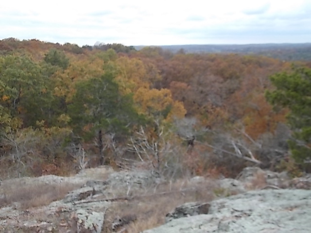
The mountain top view was wonderful, especially now that the leaves are turning color. 
Once we reached the top of the mountain, we found ourselves on a very rocky surface bald with a 
few grassy areas and short shrubs.  We started wandering all over the surface at the top, looking for the columns which were described in the book.  What we found were shorter rows of rocks than what I expected, they were 3 to 4 feet maximum height, having 4-6 sides. 
We lost all track of time as we hiked all over the surface at the top.  The sun was getting lower in the sky and we realized that we had to climb down very soon.  However, there was no exit sign; we had to find the area where we had entered the top of the mountain.   We wandered around rather aimlessly for about 30 minutes.  For me, panic starting building as I realized that if either of us fell it would be a cold night on the mountain.  No other humans had been seen the whole time we were there.  John checked his phone, no service- we couldn't even call 911.  John studied the trail map a bit more closely, and with the sun's help we got our directional bearings.  We then saw a small trail sign pointing to the path which we needed to follow.  Whew, that was the first time that ever happened to us in our wanderings.  Hope we remember in the future to always pay attention to our surroundings.  Maybe the whole problem lies with memory issues????

Thursday, October 10, 2019

Luray Caverns

According to a Luray Cavern brochure, this cave is the "largest and most popular in the East"  John and I were tempted to pass on seeing it, as we have toured quite a few caves over our lifetime. However, our son Dan seemed determined to go, and so we went just because most caverns have not failed to thrill us.  Luray Caverns were no different in their awe factor.  Seemed to me they were exactly as National Geographic once described them as "a fairy land in stone".
The caverns were discovered in 1878 by a tinsmith and local photographer.  Cold air rushing out of a limestone sinkhole atop a big hill blew out their candle.  They dug out the rock around the hole, took a rope and slid into a large cavernous room.  The cave is noted for such large rooms, because of that there are paved walkways easily traversed, no steep stairs which we are use to encountering in many caves.  In fact, a lady in our tour group managed well in her wheelchair.
Pictured above is Saracen's Tent, one of the most perfectly formed drapery structures in the world.  Just imagine making a grand entrance through that opening in the middle of those stalactites!
Above is the Wishing Well, a pond where people have tossed coins since 1954.  Once a year the coins are removed and deposited in a special bank account for various charitable organizations. In some of the other ponds in the cave there are beautiful reflections of the towering stone columns and shimmering crystalline stalactites hanging above.  It is very much a fairy land of delicate beauty!
In the cavern there is the world's largest musical instrument, the" Great Stalacpipe Organ".  It makes concert-quality music from the surrounding formations which cover more than 3 acres.  The day we were in the caverns there was no organist to play it, but our tour guide did turn on a recording of a hymn played on the instrument.  We were sure the real thing might have sounded better!
We drove back to D.C. that afternoon, and the next day John and I took a southerly route back home.  We wanted to take the scenic by-way along the New River in West Virginia.  It made our return trip a bit longer, but was well worth it!


Wednesday, October 9, 2019

Shenandoah National Park

What little time we had on our trip out east, John and I spent most of it in this park.  The national park has been know for its Skyline Drive, 105 miles along the crest of the Blue Ridge Mountains.  According to the park brochure along this drive are 75 overlooks, offering many impressive views of the Shenandoah Valley.  We did not traverse by car the entire drive, but spent some time on it taking time to stop and enjoy the fantastic sights spread out below us.

In the view of the Shenandoah Valley above the two white splotches in the midst of the picture above
is mist arising from the valley.  On our second day the view over the valley was hazy with patches of mist arising from it.  Most of the trees were still green yet, and had not yet slipped into their fall colors.
 
On the first day in the park we were anxious to hike on one of its many trails, so we chose Stony Man.  Our trail guide described him as appearing to be "reclining on the slope of the Blue ridge, gazing over the Shenandoah Valley to the west".  It is the second highest peak in Shenandoah National Park.  Viewed from the north the mountain resembles the face of a bearded man.   Pictured below is our group at the summit of Stony Man, which gives you another view of the rocky peak of the  mountain.
The hike is  a 11/2 mile round trip, the path is well cleared but still strewn with small rocks.  On our walk down the mountain John just happened to look up and did not see a rock at his feet, falling flat on his face and breaking his glasses.  Once we cleaned up his scrapes, however, he was good to go- with no broken bones fortunately.
Except for that one mishap, we had a wonderful walk on Stony Man; with a park booklet in hand we were able to take notice of some of its more interesting features.  Pictured above is yellow birch that is determined to split a large slab of rock in two with its roots.  At one time oaks and chestnut trees were the primary trees in this forest.  About in the 1930s an Asian fungus decimated the American chestnut trees, now it is the oak which dominates the forest.  Also tall evergreens add to the forest canopy.  We did see some chestnuts, mostly as logs lying alongside our trail.  They do not decay and still can be found, serving as a host for various bugs and other small creatures.
There was a trail marker near the rocky site pictured above.  In the rocks seen along the trail is the presence of various minerals, old scattered copper mining sites can be found on Stony Man.  In the 1800s nuggets of  native copper were found on the forest floor.After our day on the mountain we still had some time the next day to visit Luray Caverns which are located in the Shenandoah Valley region.


Saturday, October 5, 2019

A Trip East

John and I have had a busy fall season so far.  Two weeks ago we took a cabin at Meramec State Park, joining our daughter and her family who were tenting there.  This past week-end we took a road trip to Washington D.C. to visit our son Dan and his wife.  On highway 68, across the northern top of Maryland, we saw the brilliance of reds and yellows in the fall colors.  Seemed a bit early for them to appear, but we were driving in mountainous areas.
A day after arriving in D.C. we drove with our son Dan and Amanda to the Shenandoah Valley where we rented a cabin belonging to the Potomac Appalachian Trail Club.  The first day we hiked around the immediate area and saw the usual remnants of old farm sites, which included low stone walls as well as home fireplaces.
Our cabin had an interesting feature, a bridge to nowhere in particular.  The family who built their vacation home here, in the 1970s,  liked the artist Monet.  The lady of the house had a bridge reconstructed in her yard, similar to the one found in some of Monet's paintings.
According to a journal in the cabin, written by past visitors to the home, a black bear had been spotted in the yard in July.  All we saw of wild life were some wild turkeys- our son and his wife did see a pileated woodpecker while sitting on the porch.  And we hear many birds chattering in the trees, that alone was quite pleasant during our stay!  One last picture here is that of Virginia Creeper, whose leaves are now turning red.

Tuesday, September 10, 2019

A Day n St.Louis- the Art Museum and a Piazza

The St.Louis Art Museum currently has a wonderful exhibit on Paul Gauguin (French post-impressionist artist who lived from 1848-1903).  The exhibit is titled The Art of Invention"- very true for this artist as he become known for his writing, ceramics, printmaking, wood engraving and woodcuts.  It seemed that over his lifetime he was always creatively reinventing himself!
Pictured above is a wood carving Gauguin did of Eve with the serpent, a Biblical story of the first sin.  He created this with oak wood and paint.  There was a fair number of his wood art displayed in this exhibit, as well as a variety of other objects which he collected over his lifetime. While living and painting in Tahiti he became interested in the Maori culture and collected items pertaining to that tribe of people, which  included in the exhibit.
Gauguin seemed to be a restless soul, he did not want to paint urbanized Europe, and instead wanted to find more uncivilized places where he could find luminous vivid colors- which he certainly found in the lush tropical foliage of Tahiti.    He left his five children and wife in Denmark, traveled off to paint and find an alternative life style on that island.  He first spent two years there, returning later and spending 6 more years on Tahiti.   The painting above is titled "Landscape from Tahiti"   Over all, this was a very fascinating exhibit about an unusual, talented off-beat painter.  We enjoyed it a lot.
After spending our morning at the art museum we headed for lunch in the historic Italian Hill area of St.Louis.  A few of our favorite restaurants are located here.  After eating we walked a couple of blocks, past St.Ambrose church- a large Catholic church important to this community and built by the first Italian immigrants to St.Louis.  Piazza Imo, pictured above, is across the street from the church.  It has massive ornamental gates, benches, chessboards, as well as the marble fountain and granite walkways- very European in flavor.  It was paid for by private donors, and just dedicated this past summer.  It is a wonderful addition to the historic hill area!