Sunday, July 14, 2013

Grand Teton National Park


There are no foot hills in this park to obstruct our view of the Teton Range.  We could easily see them from our home in this park, so being away from phone or internet was not all that bad.  The mountains rise up sharply from Jackson Hole Valley.  One of our first stops in the park was to get a close view of the mountains.  Sagebrush flats are in the foreground, they give the landscape a silvery gray-green color.  Grand Teton is the tallest in the mountain range and is easily identified by its jagged peaks.
 The Teton Range rank among the youngest in the world.  However, geologic forces have been at work in this area for millions of years.  Beginning 10 million years ago movement on the Teton fault generated massive earthquakes causing the mountains to rise while the valley floor dropped.  Starting two million years ago massive glaciers flowed south from Yellowstone, eroding the mountains.  More recent glaciers have receded 15 to 25 per cent in the past 40 years.  The alpine glaciers sculpted the jagged Teton skyline and moraines ( masses of rocks and sand) have dammed beautiful lakes as Jenny Lake.  We took one of the more popular trails in the park along that lake, where we were able to enjoy additional wonderful vistas of the Tetons.  South Jenny Lake is at the bottom of Cascade Canyon, which is located in the split of the mountain range in the picture above.
 The trail took us steadily upward, about 21/2 miles to Hidden Falls.  It was a bit strenuous, like our hike Sunday, with some rock scrambling and took us a couple of hours.  From the trail we also had a great view of Moose Lake.  John remembers, when we were here years ago, that there were moose grazing by the lake.  None could be seen when we were there.
Hidden Falls was worth all the pain of getting there!  As we neared the falls we could hear them, but they remained hidden from our sight until we were right in front of them- hence the name Hidden Falls. 
 We were hot and tired, and the mist from the falls felt good.  Signs near the falls reminded us that this was a place to “be bear aware”.   Many people, us including, haul out snacks once they reach the falls, and also near the falls are many berry bushes.  Both probably draw bears to that area.   Going down was a bit easier and took us less than an hour.  As we neared the end of the trail we saw one mule deer feeding a short distance from us.  I really hate it when wildlife refuse to pose for me!  Many of my pictures are of their backsides.

Saturday, July 13, 2013

Yellowstone National Park- Part Two


From Norris Geyser Basin we drove west to Canyon Village, after a brief stop for supper.  Here we had spectacular views of the Grand Canyon of the Yellowstone River and its waterfalls. Yellowstone Park received its name because of the color of the walls of the canyon.   The canyon once slid through an ancient volcanic basin; hot water eroded the rock walls of lava and rhyolite.  The canyon is still being eroded today by the Yellowstone River.  An interpretive sign near a lookout point over the canyon noted that it is forever growing wider,deeper and longer. 
 
On North Rim Drive we stopped at an overlook and could see the upper falls off in the distance.  The lookout point also had a vista of the lower falls, and from this point it is possible to take walkways along the canyon’s rim.  It was along one of those walkways where we were able to get some wonderful views of the lower falls.  Most interesting to us was the strip of dark green flowing down the middle of the falls and a patch of snow off to its side.  The green color is most likely because of algae present in the river
   On our way back home we drove a good distance along the Yellowstone River, through forests of lodgepole pine.  One particular section of the park was quite burned, only charred stumps of trees could be seen.  It was here where we saw a large elk buck feeding.  He probably was enjoying the new vegetation springing up among the many dead trees which were strewn on the ground around him. 
 
That was pretty much our day in Yellowstone, a place of rugged mountains and volcanic plateaus.  I think that if I take away any particular memory of the park it would be of its many geysers and hot springs.  We occasionally would see, just while driving along a mountain stream, evidence of that activity by a puff of steam arising out of the water.  In the canyons and rivers of Yellowstone there are steam vents which continually allow heat, hot gases and hot water to escape. After awhile we got use to seeing large patches of denuded white and black rock, evidence of the presence of ancient lava flows and hydrothermal activity.

Yellowstone National Park


Sorry that I have stopped posting here for several days, but our latest campground was a bit removed from civilization.  We should have put in our reservations for the Grand Teton/Yellowstone area, but we failed to do that.  One would think we would wise up after the several times we have been here over the years!  This has gotten to be one of the busier national parks during the summertime.  We did find a place to park in Grand Teton National Park-problem is that it a bit too remote to receive any telephone or internet communication.  On our first day in this area we drove north from Grand Teton National Park to Yellowstone, a distance close to about 60 miles.  It is probably necessary here for me to explain what Yellowstone Park is all about- and I will use the park’s brochure to explain the peculiarities of the park.  About two million years ago, then 1.3 million years ago, and again 640,000 years ago the Yellowstone Volcano erupted and ripped open miles of mountainous terrain, leaving behind a massive caldera that stretches 45 miles from rim to rim.  The magmatic heat powering those eruptions still to this day powers the park’s geysers.   Yellowstone has a total of 10,000 of them, of which Old Faithful geyser is the most famous. While waiting on Old Faithful we took a walk along the boardwalk to view other geysers in the area..  The picture below should give you an idea as to what one of the numerous hydrothermal areas of the park looks like.  Not all of the hot spots are geysers, but just hot bubbling water or mud.  As I will explain later, minerals in the rock and microorganisms create a palette of colors from very bright orange to hues of green and blue.
 
 Well, Old Faithful is not all that faithful anymore.  I can remember coming here about twenty-five years ago and then we could count on it erupting about every hour.  Now its eruption varies from 40 to 126 minutes.  The visitor’s center near that geyser posts a schedule as to when it will erupt.  While we were there it was expected to erupt at 2:10 PM.  It was not until about 2:30 that it began erupting into its full mode.  As the time slowly passed while we were waiting on the geyser I kept thinking that surely the crowd would dissipate, but everyone stayed.  Babies cried and older children became fussy under the hot sun, but no one left.  When Old Faithful finally fully erupted there was silence among the crowd.  I can never get tired of seeing it, the waiting and wondering whether it will happen is part of the charm of Old Faithful.
 Another place where we stopped in the park is Norris Geyser Basin.  The basin is among the park’s hottest most acidic hydrothermal area.  We hiked around its Porcelain Basin and again saw a mixture of geysers, hot springs, fumaroles and mudpots.   The hot pools of warm water vary in color from azure to turquoise, prettiest of these is Crackling Lake.  It did seem to have a crackling sound,  but I thought that maybe its shimmering appearance gave off an illusion of a crackling sound.  Either way, what a beautiful lake!
 Microorganisms (thermoacidophiles) who love both the acidic and hot pools color the landscape.  Perhaps the picture below can capture some of the beauty of Norris Basin.  I will write more on our day in Yellowstone in my next posting. 

Monday, July 8, 2013

Ogden, Utah

There are no Lutheran churches in Brigham,  it does have one Methodist church which we considered attending Sunday morning.  John, however, pointed out that there is a scenic canyon and waterfalls in Ogden which he wanted to see.  Coincidentally, Ascension Lutheran church is located in Ogden and we were quite blessed to have attended church services there.  Pastor Muter had some very interesting thoughts on Galatians 6:7-16, both in his sermon and Bible study afterwards.  In the epistle Paul talks about the fact that with Christ's death we have a new spin on the law, it becomes the seed of the gospel.  Now there should no longer be rigid laws and regulations within in the church, for Christ has made all things new.  The law of God brings the love of God to us and should build up the spirit of gentleness within us as we live in relationship with each other.  The kingdom of God is within us as we live out our lives- if we do not get it right there is always God's grace and love.  They were good words to hear once again, and I was thankful we made the effort to get to Ogden for church.  After Bible class the pastor spoke with John and I about his ministry at Ascension- what  was interesting to us was that the church has a drive- through prayer window!
 
The town of Ogden can be seen in the background of the picture above, I snapped it as we were starting to hike up the Waterfall Canyon Trail.  This is a great town to live in if you want to be active outdoors the year around.  Eleven national park's are less than a day's drive from the city.  During the winter season there are three major ski resorts within 25 minutes.  The Waterfall Canyon Trail is a favorite hike for many of the locals.  It is a strenuous hike with a lot of rock scrambling.  The trail is 1.2 miles one way- does not sound like much, but it took us several hours going up and coming back down.
 It was necessary for us to stop and rest at intervals- raspberry bushes filled with ripe fruit and small streams refreshed us on the hot journey upward.  As a side note here, we have found wonderful fruit orchards near Brigham and have been feasting also on sweet cherries and apricots.  Back to the trail- many of the young adults we met on its path were friendly and encouraging to us.  I did not realize how much I missed having young people around us, which is one problem for me with our gypsy life-style!  We did make it to the top, the hike was worth it, once we saw the 200-foot waterfall.
It is difficult to see the waterfall in the picture above as it is spread out in several streams over the width of the cliff.  It felt just great to sit on the rocks below it and let its mist blow over us.  There were also some beautiful wildflowers in this area,  pictured below is a patch of penstemons. 
On our way down we noticed a man coming up the trail carrying what I thought looked like a fat walking stick.  I was glad that I asked him what it was, for he promptly played us some toe-tapping music.
It is a didgeridoo,  a wind instrument from Australia.  The young man said that he wanted to find how how it would sound when he played it by the cliffs and waterfall.  I was tempted to follow him back up to hear some more of the music but we had another waterfall to see in Ogden.   A young man we had spoken to on the trail gave us directions on how to find it.  If we understood him correctly, it is a man-made falls created by diverting the Ogden River up a high cliff through a pipe which hangs over the highway.  There is certainly a lot to see and do in this part of Utah, but tomorrow we are moving on.


Golden Spike National Historic Spike

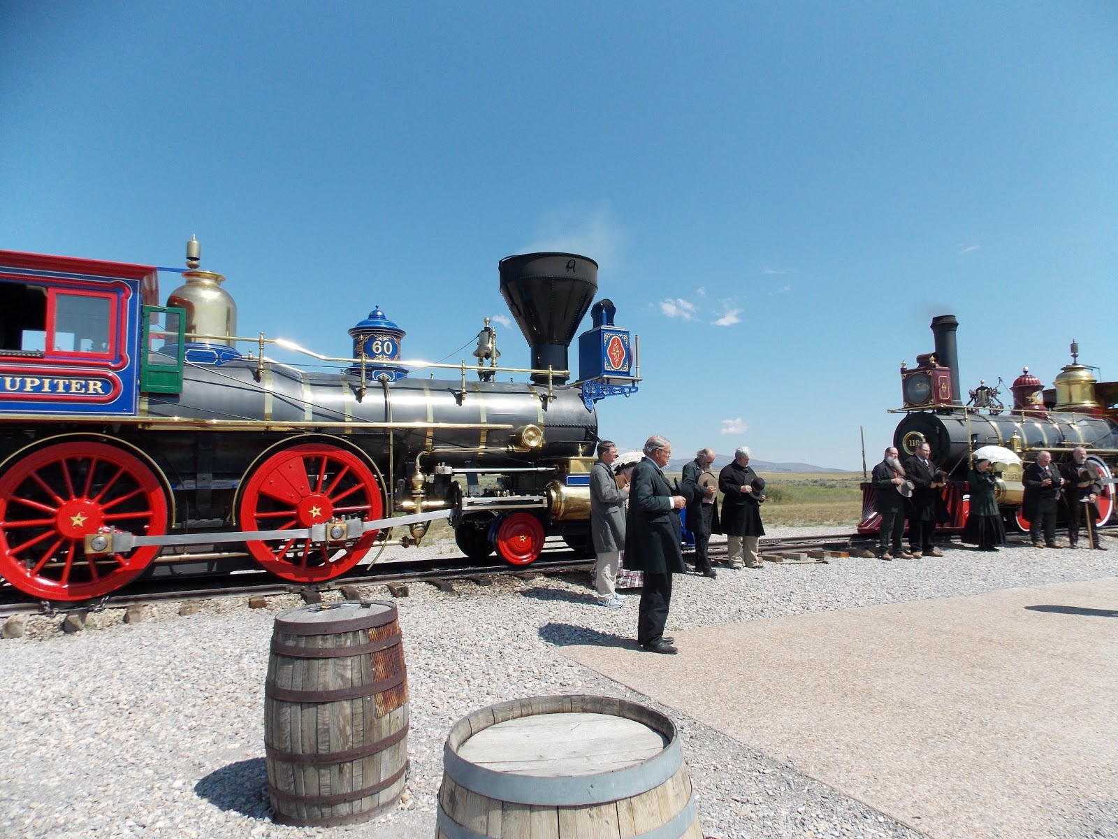
I do believe this was on John's bucket list, to see the place where the final spike was driven for the transcontinental railroad.  We had been following the history, as well as the historical sites for that railroad, since Omaha Nebraska, so it also would only have made sense to follow up on the end of the story at the Promontory Summit in Utah.  Reenactments of the story are done on weekends during the summer months, so we timed our visit to watch the commemorative ceremony of the driving of the golden spike.  The park has working replicas of the 1869 locomotives  "119" as well as the "Jupiter".  About 1.7 miles of track have been relaid on the original roadbed where the rails were joined.  The ceremony began with the two trains from the east and west meeting, after which a prayer was said.  The telegraph operator at the site sent out a message:  " We have got done praying.  The spike is about to be presented."
The details of the ceremony done on May 10, 1969 are hazy, so I am sure that the park service wrote their own reenactment.  The  prayer was followed by several speeches given by actors playing the roles of the governors of the surrounding states, as well as Central Pacific president Leland Stanford and Union Pacific  vice president Thomas Durant.   The famous golden spike was then presented to Leland Stanford who placed the spike in a previously drilled hole.  In reality, 4 ceremonial spikes were presented that day and the "last spike" driven into the railroad tie was made of ordinary iron. The telegraph operator standing by made sure the importance of the event was made known across the nation the minute it happened.  He is pictured below sitting at a table near the Union Pacific locomotive. His message was:  Dot..Dot..Dot...Done."
The story was, as we were told it on Saturday, that the two officials of the railroads were not successful in getting the iron spike in, so a foreman of the railroad crew stepped in to perform the final pounding.
Another humorous note here; during the reenactment Saturday some attention was taken away from the ceremony by a bull snake.  People jumped up on their seats and someone ran for a park ranger.
The ranger reassured everyone that it was a harmless snake who only kills rattlesnakes.  He was unable to get the snake to go away because the snake then hid under the bleachers.  All the ranger could then do is stand by with a net and a pole to keep everyone happy.  After the ceremony John and I drove on an auto trail along the old Central Pacific roadbed, and took one hike off that road to look at the old fills and trestles.  In the end, the two railroad companies, lacking precise instructions from Congress as to where to meet and spurned on by financial rewards for building the railroad, prepared grade past each other for 250 miles.  President Grant put a stop to that and chose Promontory Summit as the meeting point for the transcontinental railroad.  To get to the meeting point both railroads had to climb a long grade which involved many cuts and fills.  All of the final track has been replaced by the causeway across the Great Salt Lake.

Saturday, July 6, 2013

Antelope Island State Park- Part Two

After our hot trip up the Buffalo Point Trail I was ready for a swim in the lake.  We stopped at Bridger Bay, the only public beach available on the island.  However, one look at the distance I would have to walk under the hot burning sun to get to the water, I changed my mind and decided instead to join John in the nearby cool cafe for lunch.  The picture below should give you an idea of the distance needed to hike from the beach house and cafe, across a short boardwalk and then a great expanse of beach before getting to the lake.  The brown-roofed building in the picture below is the cafe.  The lake is indeed experiencing a shortage of water!  It is hard to believe that in 1982 the island was flooded and needed to be closed for ten years.
By the time we had finished lunch a storm front was moving in and the weather had cooled considerably.  We changed our mind and hiked down to the lake.  We first walked on a small amount of sand, and then had to deal with a very rocky beach.  We imagined that at one time the hard stoney area had been the bottom of the lake.  Many small insects swarmed over us, they seemed to be the size of fleas.  Smell of dead fish permeated the air, and one dejected large bird walked past us dragging one of his wings.  He looked like he had just been in a fight and was still too much in shock to worry about us.  I did wade in the water,  that was all I could get myself to do.  It would have been a unique swimming experience, but I had to pass.  The lake water felt quite warm- not surprising as in most places it is quite shallow,  its deepest part is 33 feet.
 
 The island's namesake, pronghorn antelope, are native to the island.  Mule deer (pictured above) and bighorn sheep are the other large herbivores on the island.  We saw the mule deer on our drive to the Fielding Gar Ranch.  John Fremont and Kit Carson explored the island in 1845, and in 1849 Fielding Gar established the first permanent residence on the island.  We arrived there too late to take in a tour of the house, but we were able to walking around outside on the ranch grounds where we saw plenty evidence of its early pioneer days.  We were told that the house had been modernized into a 20th century home.  As I was gazing from the ranch grounds toward the salt flats I could not help thinking that it seemed a very strange setting for a ranch.  However, for 133 years it was a working western ranch.
Near the ranch we saw what appeared to be large number of the island's buffalo, they were probably on what looked to be the best grazing land on the island.  The sun was getting low in the sky at this time and it was time to head back to Brigham City and home.


Antelope Island State Park

The Great Salt Lake has ten islands, of which Antelope Island is the largest.  After driving past the city of Ogden, Utah we drove onto the causeway which led us into the park.
Our first stop on the island was the Visitor's Center where we learned a lot about the Great Salt Lake. It is the largest natural lake west of the Mississippi, and is located in several wide flat basins.  It is salty because it has no outlet.  Rivers and streams constantly bring in small amounts of salt which have been dissolved in their fresh water flow.  Because of its mineral content the Great Salt Lake is so dense that it buoys at least 25% of the human body above its surface.  The lake's salinity ranges from 25-28%, two million tons of chemicals are extracted annually from it for commercial use.  Currently the lake level is down and large slat flats cover the island.  At first glance it seems to be a place of stark desolation.  No nice sandy beaches here!
As Wallace Stegner (American historian and novelist) has noted:  "it offers no refreshment, and only beauty in place of recreation".  As we found out Friday, the island is also a land of contradictions.  It has more than 40 major fresh water springs.  Those springs support the island's wildlife and vegetation.  As we were leaving the Visitor's Center John noticed some strange birds scurrying on the ground.  They reminded him of  the chachalacas we had seen in Texas.  Consulting our bird book, we later discovered they were chukars.
Bison are the island's most famous residents.  By the late 1800s there was fear that the American bison were becoming extinct due to excessive hunting and killing of them.  In early 1893 12 of them were introduced to the island and are now the foundation for today's herd of 500 to 700.  We took Buffalo Point Trail up a hill to get a view of the valley and also to look for herds of buffalo.  What surprised us was the evidence of their dung on the trail as well as on top of the hill!   Another interesting feature of the trail was the large rocks which are strewn over it.  They are comprised of smaller colorful rocks which look like they have been imbedded in concrete.  A park's brochure said that the large rocks were tufa, deposited by the pre-historic Lake Bonneville (the Great Salt Lake is a remnant of that ancient body of water).
  At the top we only saw a few solitary bison grazing below- we did see a large herd however, by the end of the day. More on that in my next posting.


Logan Canyon Scenic By-way, Part Two

The docent at the Bear River Refuge stressed that when we visited this canyon we should be sure to hike the Limber Pine Nature Trail.  This trail crowns the canyon's 7,800-foot summit and is named for what was once believed to be the oldest and largest living limber pine tree ( since then limber pines have been found in Oregon which are two thousand years old). Scientists have discovered that this giant is actually five trees which have grown together for for a relatively young 560 years.
Just before we reached this point on the trail a large buck elk came thundering past us, he was moving so fast that we only could catch a quick glimpse of him, I did notice that he had a large rack of horns!
We noticed on our hike that not all of the fir tree are as healthy as the ones pictured above.  Possibly because of drought conditions, some of them have become afflicted with a fungal disease called rust.  The tree's reaction to the disease causes it to develop malformations called "witches broom".
  It was on this trail that I had my first sighting of a western tanager.  I only had a quick glimpse of him, but his colors make him easy to identify; a red head and bright yellow body with black markings.  Our next stop of the day was at the Bear Lake Overlook.  The lake at times has an incredible turquoise blue color, when we were there it was not so obvious because of the skies being overcast. The striking color is caused by a natural phenomenon that occurs as a result of limestone particles being suspended in water.  The particles absorb light and reflect varying shades of color from azure to turquoise to sky blue.
 
 Bear Lake lies in Garden City, a town famous for its juicy Bear Lake raspberries.  Unfortunately they are not ripe yet.  Still, we were able to enjoy last year's crop at the restaurant where we had supper.  My grilled chicken had a raspberry sauce on it, we were served homemade rolls with raspberry jam, and a dollop of raspberry sherbert to end our meal.  And John just had to start his meal with a raspberry shake! 

Friday, July 5, 2013

Logan Canyon Scenic Byway

When we visited Bear River Refuge a docent at the Visitor's Center mentioned that we should visit Logan Canyon.  She and her husband have a cabin there and return to the area every week-end.  We knew that there are many things to see in this area, but until then did not have any specific ideas firmly in mind as to what we were going to see.  We should have realized that, because of the hot weather here, many people would be heading to the mountains and lakes for the holiday week-end.  Anyway, Independence Day found us and many others heading for Logan Canyon.  Most of Logan's Canyon's landscape falls within the borders of the Wasatch-Cache National Forest.  Cache Valley was given its name because of mountain men as Jim Bridger who hunted in this area and cached many beaver pelts (buried them underground) until selling them at the annual fur rendezvous.  Unfortunately by 1840 much of the beaver population had been decimated, because of the heavy trapping for furs.  Our first stop on the byway was Ricks Springs.
Hydrologists have determined that the spring is both a spring and a diversion of the Logan River.  In 1972 scientists discovered the diversion when they placed green dye in the river and it appeared downstream at Rick's Spring.  Dye tracing has also shown that water from the spring also originates from disappearing streams to the northwest, and 2,600 feet in elevation.  Water that flows out of Tony Grove Lake also comes back up at Ricks Spring.  That lake was our next destination, and its parking lot was full because of the holiday.  Most fortunately we found a spot to park further down the road.  I was ready to leave the area because of it being so busy- had we done that we would have missed the highlight of our day.
Unless my memory fails me, I do not believe we have ever visited an area with such an explosion of wildflowers!  We took a walk around the lake and I could not stop taking pictures.  They were in every color imaginable- most striking to me were the vibrant blue of the bluebells and lupine, the delicate white of the columbine, the brilliant red of the gilia, the shy pink of the wild rose, and the stunning yellow of the sunflower, to name but a few that caught my eye.  The chipmunks and blue dragonflies were also numerous in number, when I took my attention off of the flowers I came to realize how close I often came to running into them.  Many birds also seemed to be singing high in the treetops.  But still for me it was all about the flowers, and they seemed to have no problem in growing around the large rocks of the lake.
The lake is considered the crown jewel of the Bear River Range.  It was formed by large slow-moving glaciers.  Large boulders around the lake are evidence of that powerful glacial activity.  I should end this with a picture of the lake, but I have too many pictures of the flowers which I want to share with you.  The rest of our day in Logan Canyon will have to be continued in my next posting.


Wednesday, July 3, 2013

Bear River Migratory Bird Refuge

We spent a wonderful afternoon taking the auto tour of these wetlands.  Here we saw about the same variety of birds which we saw last winter in the Rio Grande Valley of Texas.  I would bet they are confused about the current heat wave which this area is having now- it is very unusual for this area of Utah to have triple digit temperatures during the summer!  The refuge is located where the Bear River flows into the northeast arm of Salt Lake.  The wetlands are surround by arid desert lands and are consequently a very important oasis for waterfowl and shorebirds.  Large number of avocets, one is pictured below, can be found here.
Another common bird found in this park is the curlew, pictured below.  Over 250 species of birds call this 76,000 acre refuge their home. This includes birds of prey as well as perching birds, doves and owls.
In the 1920s due to loss of marshes and huge bird die-offs from botulism, local residents and organizations urged Congress to protect this valuable resource.  In 1928 the Bear River Migratory Refuge was created by Presidential Proclamation.  From December to February this park has the lowest average bird population.  March is the first month to welcome returning birds as the cinnamon teal, cormorant, white pelican, avocet, curlew, California gull and black-neck stilt (pictured below)- and that is only to name a few of the total different species. More birds arrive during the month of April.  For some it is a brief stop before they fly on to breeding grounds further north, others hang around here for the summer.   We later learned that it is the
the nesting area of the white-faced ibis.  We watched a film at the Visitor's Center, Wings of Thunder, by National Geographic and from that film we learned it is an impressive experience to be here when flocks of birds return to the refuge.  The movie describes the sound as "the distant sound of thunder". Springtime is also a great time to view the bird's mating dances.
 
As we drove through the refuge we could see large salt flats, areas where the water has dried up because of current drought conditions and the need for farmers to irrigate their land during the summer months.  In those areas we saw many large dead fish.  Still, Bear River looked full and up to its banks, and we were satisfied with the variety of water and shorebirds we saw.  There were large numbers of  white pelicans, egrets, white-faced ibis, and grebes, pictured below.  Also present in large numbers were many different species of gulls.  Unfortunately the heat and presence of many different flies kept us from being able to get out of the car to take  in all the sights and sounds of the refuge, however it all was still quite enjoyable.  We would love to return to this place during the spring and fall months, if that would ever be possible.

Brigham, Utah

Yesterday, Tuesday we drove southwest from Rock Spring, Wyoming and crossed into Utah.  Shortly after leaving Wyoming we immediately noticed a change of landscape- from grey hills having sparse to no vegetation to towering red rock formations and lush green farmlands.
We stopped at a rest area which also provided information about the state and, while John was staying cool inside the center and picking up brochures,  I was outside watching the activity of large prairie dog colonies.  I also found some opportunities to finally snap pictures of magpies, which can only be found in the western states.  They are noisy, aggressive birds, in the family of crows and blue jays.
  We are now parked in Brigham City.  The Mormon Church of Jesus Christ of the Latter Day Saints settled here at the mouth of Box Elder Canyon in the early 1850s.  There are about 25 of their house churches in Brigham, however in the center of the town can be found the temple and tabernacle.  In this town of about 18 thousand people, there are only two churches of other denominations.
Pictured above is the Mormon temple.  A large welcome sign in Brigham announces another feature of the town which the residents are proud of and are sure to mention of it to tourists.
 The welcome sign notes that the town is the gateway to the "World's Greatest Wild Bird Refuge".  More on that in my next posting.  You may also notice a rock wall behind the sign- that is the Wasatch Mountain Range,  which provides a towering backdrop for the town.