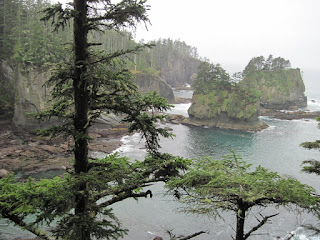
We left Sequim Friday morning and headed to the northwestern corner of the Olympic Peninsula
with little hope of any improvement on the weather. We stopped for a picnic lunch at a beach along the coast. Hard to believe that looking out over the ocean we could see Canada! About 18 miles across the Strait of Juan lies Victoria, the capital of British Columbia. After lunch we drove to Cape Flattery, one of the most dramatic "land's ends" on Earth, marking the most northwestern point in the continental United States.In a year's time John and I have traveled to the four corners of the United States! On Cape Flattery we hiked to an observation deck from which we could view the deep caves and grottoes carved into the sandstone of the Cape by the pounding surf. It is estimated that in 200-300 years time this maze of sea caves will be washed away by the force of the ocean's waves.
Cape Flattery was named by Captain J.Cook. He named this important nautical landmark that "flattered" him with the hopes of a safe harbor(there was none).
Hiking around on the Cape we thought there was a skunk near our trail because of the presence of its familiar odor. We then came upon some skunk cabbage. We have been seeing a lot of that plant in the marshy areas where we have been hiking. It may have a bad odor,but it does have a pretty flower.
At Cape Flattery is the town of Neah Bay, the center of the Makah Nation land. It is also the location of a museum of artifacts from archaeological digs, most notably the Ozette Village which existed about 500 years ago. Something which was quite fascinating for me to learn was that the Native Indian in the northwest made clothing and hats from cedar bark. They pounded it until it was soft and fluffy, pliant enough to be woven on their primitive looms. The cedar tree was their most abundant resource and they made many items from it.


No comments:
Post a Comment