Thursday, March 10, 2011

Las Colinas, Irving Texas

Las Colinas, touted by some as one of America's most important business centers, is located within the city of Irving, Texas ( that city is located west of Dallas). The visionary who built Las Colinas was Ben Carpenter; in 1973 he unveiled his plans for the business district. The seed for Las Colinas was his family's ranch, El Rancho de las Colinas- the little ranch in the hills, located close to this area. We drove there to see the sculptures of the mustangs, located on the granite Williams Plaza in Las Colinas.
Looking at those horses I could not help but get a feeling of their speed and strength. The artist, Kenyan- born Robert Glen, collaborated with Ben Carpenter on their creation and placement in Las Colinas. The artist started the process by studying the mustangs in Spain. Glen then returned to Africa to begin the sculpting of the horses. He subsequently flew the nine horses to a foundry in England where the bronze molds were poured. By the early 1980s the sculptures were ready for unveiling in Las Colinas. In the office building behind the sculptures we toured an art gallery which had more of Glen's artwork. Most the subjects of his sculptures are of the wildlife and natives of Africa, beautiful pieces indeed. Glen returns to this art gallery about once a year. He also did a sculpture of Ben Carpenter, which is located in another area of Las Colinas.
Near Carpenter's statue are located the Bluebonnet Hill Cows. They are five cows scattered over a hill, each one made of a different type of marble. The artist is Harold F. Clayton.
From Las Colinas we drove to the National Scouting Museum which is located in Irving. John had been a scoutmaster and I had been a cub scout leader so we had some interest in the museum. However, our main goal in seeing that museum was to see the world's largest collection of original Norman Rockwell scouting art.
The artist's connection with scouting spanned some 64 years. He was art director for the scouting magazine Boy's Life for many of those years. Rockwell defined scouting, as well as the American life, during the mid-20th century. His last painting for the scouts was done in 1976 (he died in 1978).

Tuesday, March 8, 2011

Bureau of Engraving and Printing

What a difference 24 hours makes here in Texas! Yesterday morning the temperature was in the low 40s, we had our little heater going and I stayed around under a blanket until almost noon. Today when I got up it was 59 degrees! Anyway, back to yesterday. With it being cool and windy I was not excited about stepping outside. John checked the tour books and found one place where we could be inside, which is the Bureau of Engraving and Printing. We headed out and had a terrific day, not only at the bureau but also at the Fort Worth Botanic Gardens. I have no pictures of the bureau, not even of the outside. There is tight security there, needless to say. After parking we went into a visitor's center where we had to go through a security search.  We then boarded a bus which took us into a building where the currency of America is made- the only other place where it is made is Washington D.C. We had a guide who led us through viewing areas overlooking rooms where big sheets of paper are  fed into printing machines. The printed sheets are then manually examined, cut, and the final product is stacked into bricks. The bricks are loaded onto pallets and then are ready for transport for to the Federal Reserve Bank. That is a very simplistic explanation of what we saw, the production of our bank notes is a bit more complicated than that. Actually there is a lot of technology involved, much of which went over my head. There is the engraving of the bill, printing of it with many different colored inks( 19 tons of ink are used daily at both Fort Worth and Washington D.C) and adding security threads on the notes to prevent counterfeiting. The face of the bills are changed every 7 to 10 years also to prevent counterfeiting. The paper the notes are printed on are 75% cotton and 25% linen. The final product is tested in washing and crinkle machines and is soaked in 9 different solvents. The Bureau of Mutilated Currency has probably seen everything that the bills have been exposed to. The bureau is only located in D.C. and receives about 30,000 claims every year. If they can piece together 51% of your mutilated bill, they will refund your money. It may take some time as forest fires, tornadoes and floods slow them up a bit. I did not know that termites chew in circles! At the bureau I saw bills which had neat holes on them; if that happens to the bills you place under your bed, you can correctly assume you have termites.
By the time we finished our tour of the bureau the sun was out. We drove over to the Fort Worth Botanic Gardens. These gardens are almost as good as the Shaw Botanical Gardens in St.Louis, maybe even better because there is no entrance fee( you do have to pay $1.00 to tour the Conservatory). The above picture is a flower of the shell ginger plant, located in the Conservatory. We discovered, while walking through the gardens, that in the Dallas-Fort Worth area spring is well under way. Below is a picture of a Lenten rose; quite appropriate as in a couple of days we will be entering that season of the church year. It is in the buttercup family and native to Greece and Turkey.
I will conclude this posting with one more picture, that of the star magnolia flower.

Sunday, March 6, 2011

Dealey Plaza in Dallas

We just spent a wonderful week-end with our son Dan and his fiance Amanda. Amanda's parents live in Arlington, the city where we have parked our rig. It was great that, besides visiting with our son and Amanda, we also were able to get acquainted with her parents before the wedding in July. Yesterday, Saturday, we drove into Dallas to tour that city together, especially the west end of it. It was interesting walking the streets of downtown Dallas and viewing its skyline of modernistic architecture. Below is a picture of some of the buildings. I took the picture below standing at Dealey Plaza. In the background of the picture is Reunion Tower, the focal point of the Reunion area, a settlement of French emigrants in the 19th century.
 Dealey Plaza is "The Front Door of Dallas", the cradle of Dallas history and a source of civic pride. It is the major gateway to the city from the west. And yet that historic focus changed dramatically for Dallas on November 22, 1963. The picture below was also taken from the plaza, and in the  background notice a large brick building. That is the Texas Depository building, the building from which allegedly Lee Harvey Oswald shot President John F. Kennedy in 1963. The sixth floor, from which the sniper shot at the presidential, is now
 a museum.
In the museum John F. Kennedy's life, death, and legacy are chronicled. More than 400 photographs, artifacts and models are displayed. Short films and an audio guide replay the historic radio and television broadcasts of the events before and after the shooting. The exact location of the sniper's perch and the storage space where his rifle was found is set up exactly as the police found it. It all was very impressive to view, as well as very sobering. In the museum Saturday we were shoulder to shoulder with many people from all walks of life and of different ages ( many of the younger people probably had been born after 1963), but they all seemed to have the same quiet and pensive mood which I felt.  It appeared that the horrific event hit everyone, including myself,  with the same impact it had some 48 years ago. From the Texas Depository we walked along the grassy knoll ( where some thought that a lone bullet had been shot at the motorcade from another location), and looked over Elm Avenue where the event had occurred.

Thursday, March 3, 2011

Fort Worth Stockyards National Historic District

The Coliseum for the stockyards, pictured above, was the place where stock shows went on annually for 34 years. The last one was held in 1936. It was also the birthplace for indoor rodeos to be held; they are still continuing today, year around, in the Coliseum. Over the years the arena has been the site for many cultural, religious and civic events. President T. Roosevelt spoke here in 1911 and Enrico Caruso sang in the Coliseum in 1920.  Billy Bobs, the world's largest honky tonk hall, is connected to the Coliseum. It was once a cattle barn. We toured the stockyards where very little is happening any more. The city of Fort Worth keep a few longhorn cattle around for educational purposes and hold a cattle drive daily for tourist entertainment. We were able to observe a drive while we were there.  I was expecting some kind of  rip-roaring action of rushing horses and cattle bawling but the only noise was that of the cowbells tinkling and the sound of the lead cowboy's voice constantly  talking to the cattle. He spoke to them in a loud  soothing voice, repeatedly encouraging them to keep moving.  A  very tame cattle drive, I must admit.
On the wall of a building in the historic district is a diagram of a cattle drive. It depicts where the cowboys are positioned during the drive with the chuck wagon leading the way.  If you are interested in more of the details you will need to enlarge the picture to read the captions. I found that poster fascinating.
We toured the Texas Cowboy Hall of Fame, which is also in the historic district of Fort Worth. What I found most interesting there is a wagon collection which features more than 60 antique buggies, carriages, carts and wagons. There were wagons and carts for hauling everything from gas to produce to diary products and laundry (to mention only few). Until I saw this awesome collection of wagons today I never had given much thought as to how we transported our goods before trucks and cars came into the scene! While touring the museum we discovered that the actor Tommy Lee Jones was inducted into the Cowboy Hall of Fame in 2009  for his accomplishments as a horseman (plays polo) and rancher. Below is a picture of the first steer wrestler, W.Pickett (1870-1920).

Wednesday, March 2, 2011

San Marcos

On the last day of our stay in New Braunfels, Monday, we drove to San Marcos. It still looks a bit like winter down here as the deciduous trees are bare of their leaves. However I was pleasantly surprised to see in San Marcos two flowering redbud trees.
One mile northwest of the town is the headwaters of the San Marcos River at Aquarena Springs. It was the last day of February and many people were either swimming in the river or on the rocks sunbathing.
The clear flowing river stays at a temperature of 72 degrees year-round. The town has numerous bike trails following along the river and through several parks, including a park reserved only for Texas State students. While we were there students were taking to the waters with canoes and kayaks. What a lovely town to attend college!  Riding around town on our bikes we saw a statue of Chief Placido and the Tonkawa Tribe. The Native Americans inhabited central Texas and befriended the early "Texans".  Chief Placido was a scout for the Texas Rangers and a friend of Sam Houston and Stephen Austin. In his right hand is a peace pipe.

Sunday, February 27, 2011

Austin, Texas

 Today we again attended Peace Lutheran Church. During the service the youth reported on their experiences the last two days with a 30 hour hunger fast. During the time of the fast different participants experienced a night of living outside in cardboard boxes (to experience homelessness), assembled layette kits, and worked for Habitat for Humanity as well as the local food pantry. They also raised enough money to sponsor some hungry children through World Vision. Way to go, Peace Lutheran! Yesterday we were in Austin and spent most of our time at the Texas State History Museum. The capitol of Texas can be seen down the road from the museum. I was wondering who the figure was on top of the capitol and found out soon during my tour of the museum. In the museum I saw the original Goddess of Liberty, who once sat on top of the capitol. She holds the Lone Star of Texas in her hand.
While driving around Austin I noticed the sculpture pictured below, and wondered what I had missed after learning so much of Texas history in the past month.
The lady was Angelina Eberly a local hotel keeper in the mid 1800s. Sam Houston did not want the capitol in Austin. In late 1842 he sent a contingent of Texas Rangers to retrieve government documents, housed in Austin, to bring them to Houston- where he wanted the capitol to be located. Angelina fired the cannon and alerted the townspeople who caught up with Houston's men and took back the papers without bloodshed. Way to go Angelina!  After touring the museum we drove to to an area on South Congress street which  reminded us of the Loop in University City, Missouri. Many people were milling about on the streets there last evening. In this area are numerous eclectic shops, restaurants, bars and various music venues. There are also food trailers along the streets offering a variety of foods including cupcakes ( that place had a long line of customers all evening, John had to give up any hope of getting that sweet and found some ice cream instead).

Saturday, February 26, 2011

Return to Enchanted Rock

We returned to this area yesterday to climb the massive rock. Enchanted Rock is supposed to be the second largest granite formation in the country. We are not sure where the largest is located, John thinks that it is Stone Mountain in Georgia. For whatever reason, John wanted to return to this park by way of the road we took when we got lost leaving there last week. He had a feeling it would be quite scenic. He was correct. As soon as we turned on this road we started climbing and soon found ourselves driving on a ridge overlooking a valley. That was the first of  several beautiful vistas overlooking the hill country.
John said the scenery on this road reminded him of some old western movies, with cowboys riding down canyons and shooting at  the bad guys hiding behind the tall rocks. Strangely enough, just before entering the park, we saw a historical marked which noted that the Texas Rangers fought the Comanches on Enchanted Rock in 1841. Fortunately the German immigrants eventually signed a treaty with them and then coexisted peacefully with the Native Indians. We hiked up Enchanted Rock and then took a loop trail around its base. A science class of middle-school children were there at the same time from Austin. Their teacher told us that the class has to get 40% of its learning outside. I think that I would have learned a lot more in science had that been the way I was taught growing up!
Rock weathering and erosion are natural sculpting processes which produce the large boulders seen in the picture above. And fractures in the rock provide shady, moist environments for such plants as cacti, yuccas and grasses. We saw several of those little ponds while hiking around the top of the domed rock.
 
At the base of the rock we did some rock scrambling while hiking through Echo Canyon. It all was very enjoyable, despite the sun being out in its full glory. It will not be much longer when the best time to be hiking here will be early morning or late afternoon.

Friday, February 25, 2011

San Fernando Cathedral, San Antonio

This was our last stop for the day on Wednesday. What immediately caught my eye as I entered the church was the golden altar. It has three golden retablos (altar pieces) which were completed in 2003. A memorial plaque on the wall near the altar notes that the retablos were provided by an individual in memory of two prominent families of San Antonio for their religious and civic activities.
To explain the next picture it is necessary to go back to the year 1731. With a goal of populating and preserving Spain's hold on the region, the Spanish government sent several dozen colonists from the Canary Islands to the mission, San Antonio de Valero. In a chapel of the cathedral there is a statue of the Patroness of the Canary Islands. It was given by the government of the Canary Islands in 1884 in "memory of 56 Canary Island immigrants who came to San Antonio in 1731 and founded San Fernando".
Also of note in this church is a small room where there is a marble coffin said to contain the bodies of three heroes of the Alamo; Bowie, Crockett, and Travis.

Thursday, February 24, 2011

San Antonio, Texas

Part of the River Walk is pictured above. John and I have been to San Antonio several times now and the River Walk is always a destination for us in the city. It is a fun place both for walking and dining. The landscaped riverbanks are bordered by nightspots,restaurants as well as handicraft shops. Before stopping at the River Walk for lunch, however, we paid a visit to the Alamo. That is another place we have been to before. Interestingly enough, we were there on the first day of the siege of the Alamo, February 23. It happened in 1835. In 13 days the Mexican army subdued rebellious Texans who fought behind the walls of the old mission fort. The fort was built in 1718 and originally called San Antonio de Valero. When the Spanish cavalry took the fort over in 1803 they named the fort Pueblo del Alamo (possibly naming it for the many cottonwoods which lined the nearby San Antonio River). The Alamo was meant to be a mission originally;   the battle of the Alamo took place in the church on the mission grounds and that building, plus the barracks of the fort, are the only buildings left standing. While we were there a press conference was being set up in front of the Alamo and a singer was entertaining the crowd with the Texas songs of George Strait.
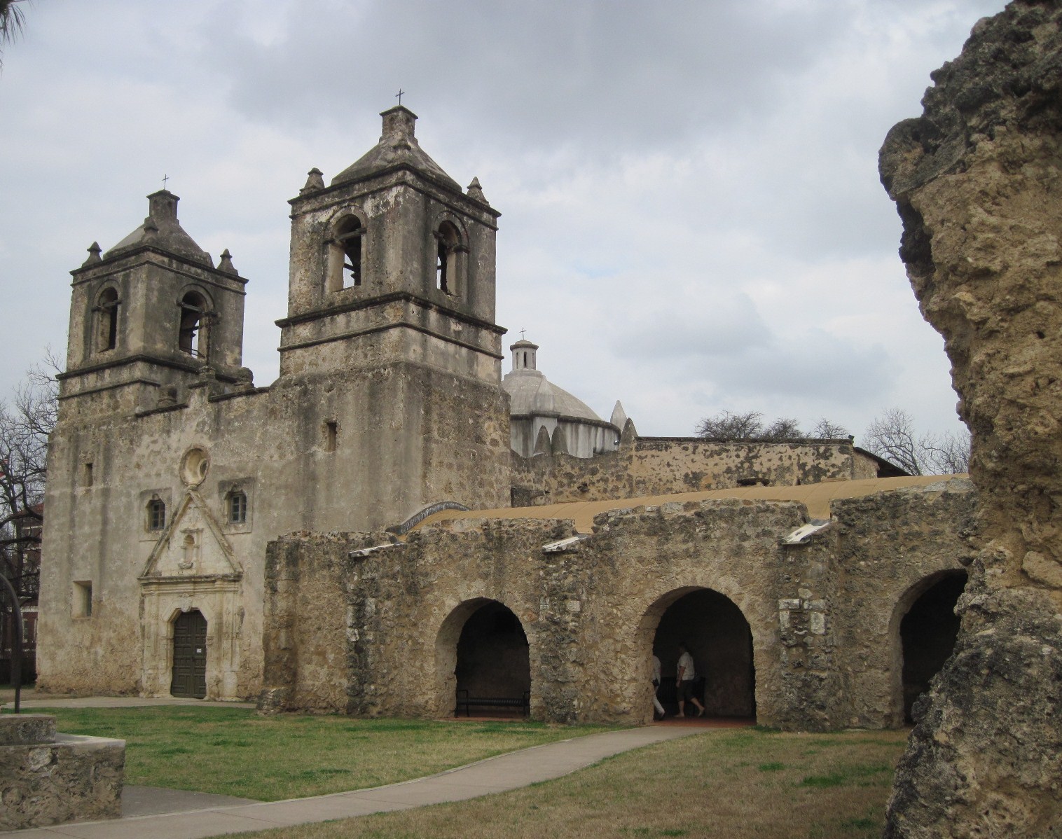
There are a total of four mission sites in San Antonio. Mission San Jose is in the process of restoration so we drove on to the Mission de la Conception which was relocated to its present location in 1731. This is a massive church with twin towers and a dome built by the Franciscans. It is the oldest unrestored stone church in the country. Reportedly it is known for its great acoustics as well as for its wall art.
Wall art, or frescoing, was a skill taught to the mission Indians partly as a tool to teach them Catholicism, but also the frescoes served to highlight architectural features as well as to hide construction flaws.

Wednesday, February 23, 2011

Gruene, Texas

This historic town is part of New Braunfels. It is primarily a 19th century historic district. It was settled in 1845 by Ernst Gruen. At the time there was no land to be had in New Braunfels so Ernst bought land down river (Guadalupe River). His second son, Henry, built his home in the 1870s, and planted his surrounding land with cotton. The cotton business brought 20 to 30 more families to the area. In 1978 a mercantile store was built and a cotton gin powered by the Guadalupe was added soon after. We ate our supper in the old Gristmill River Restaurant, which used to be the old cotton gin. We had a table outside overlooking the river.
The town declined in the early 20th century because of boll weevil infestation of the cotton. In 1974-75, when much of the old Gruene was sold, new purchasers arrived and new businesses were established. All of Gruene was placed on the National Register of Historic Places.The old mercantile building is now a general store with everything, literally, from soup to nuts.
 After supper we felt that we should not leave town without spending some time in the old dance hall, the oldest in Texas. Gruene Hall was built in 1878, and, despite the many financial reversals of the town, it never closed. This is where Lyle Lovett, George Strait and Hal Ketchum got started.
At the hall we heard the singing of a popular Texas musician, Shelley King. She, along with her two cohorts, sang a variety of bluegrass, country and R&B. Thought we would stay only to hear a few songs, but enjoyed the music so much that we hung around longer than planned. And it was a good thing we did, had we left any sooner, we may have missed running into an old friend from St.Louis, John Loesel!  He was in the area to take bar examinations in San Antonio.

Tuesday, February 22, 2011

Natural Bridge Caverns

We attended church on Sunday at Peace Lutheran in New Braunfels before driving to the caverns. After first sitting down I noticed many banners on the walls, for all the seasons of the year. One which particularly caught me eye was the one above the baptismal font, pictured below.
I was told later that a church member, Betty, had died recently and she was the one who had made all the banners. As a memorial to her, all of her banners are currently being displayed. The above bannerbrought me realize that it is just as appropriate to have such a banner displayed for funerals as well as baptisms. After the service and lunch we drove a short distance out of town to the caverns. Before entering the caverns we saw the natural bridge of stone by which the caverns got its name, Natural Bridge.
The entrance of the cave was discovered in the 1930s. In that area was found the bones of a black bear, the molar of a Native American, and remains of bats and rats. There are no living creatures in the caverns today. What is left of the bats in the cave are piles of black guano, which we saw during our tour there. In 1960 university students discovered passages which led further into the cave. It was discovered then that the cave is 2.5 miles long(we only walked .5 miles into the cave, but 180 feet down). The underground world of this cave is quite impressive with its natural formations. The tallest column stands at the height of 50 feet. Below is a picture of the one massive room found in the cavern. Some of the formations can be seen there.
Any time you tour a cavern you receive warnings not to touch the walls. The oil on your hands can prevent the growth of cave formations. In these caverns there are no formations in the places where there is bat guano. However, there is little to prevent plant spores from being carried in on clothes. In the caverns there is one living plant, a fern, which was probably brought in on someone's clothes. Artificial light in that part of the cave then encouraged growth of the fern. One other interesting note; this was quite a humid warm cave, like about 80 degrees. Cave temperature usually reflects the average temperature of the air and ground surrounding it.

Monday, February 21, 2011

Enchanted Rock State Natural Area

After we toured Fredericksburgh we decided to take a short side trip to see this state park before heading home.Driving through the picturesque countryside we saw a few of the original stone German farmhouses. And it was possible even to see that German influence on the names of the roads- many of them had the names of the first settlers like Weinstein, and another simply had the number eighteen- Achzehn.We soon saw the large rock off in the distance.The rock is a massive dome of granite, famed in Native American legend and said to be the site of human sacrifices. The dome is about 640 acres in area and about 1,825 feet high. It is a popular area for rock climbing and rappelling, or just plain hiking.
The sun was setting when we got there, so we thought maybe we would put off hiking the rock for another time. As we drove out of the park, John thought he could save us some time by not returning to Fredericksburg and instead taking a road that would by-pass the town. That was a mistake. We ended up on a county road through private ranch land. It was narrow and winding, with signs warning us that it was an open range. We drove over many cattle guards on that road and passed a lot of cattle, a few of whom would wander nonchalantly across the road in front of our car. We also saw lots of deer, a few darted in front of our car. Darkness fell, and I saw the silhouette of a fox fly over the road in front of us and smelled a skunk. Hard to believe that earlier I had considered camping at Enchanted Rock!  We were down to a quarter of a tank of gas and had no confidence anymore as to where we were. I started to do some serious praying. Soon a truck passed us (the first vehicle we saw on that road), and then the houses we started seeing had lights in them. Previously whatever ranch buildings we had seen looked to be abandoned.. We came to a small town with signs pointing the direction to Fredericksburg. We returned to that town and, feeling a bit tired, took a motel for the night. Fortunately I had left our cat plenty of food and water!

Sunday, February 20, 2011

Fredericksburg, Texas

We just had a great past two days touring Fredericksburg and the Lyndon B. Johnson Ranch. It was topped off last night here in New Braunfels where we attended a magnificent concert by the Mid-Texas Symphony. The concert had a guest violinist Charles Yang who played Vivaldi's The Four Seasons. We drove to Fredericksburg on Friday. This again is the beautiful hill country, and in this area are many peach orchards and wineries. We met some friends in Fredericksburg whom we had known from back in St.Louis, Jim and Diane Mayer. After meeting for lunch at the Bavarian Inn (great German food there)  we toured their church Zion Lutheran.  Zion was one of the first churches in town, the congregation was formed in the 1850s. Originally, as in New Braunfels, the town had only one church for Protestants, called the Society Church or Vereins Kirche. A replica of the church is pictured below.
The Pioneer Museum was our next stop in Fredericksburgh. Here we saw original pioneer homes complete with furnishings of the 1800s. The variety and quantity of artifacts is quite impressive.The German immigrants brought very little in the way of tools with them from the old country. What they did not have they made, so they could  build sturdy homes, furniture, kitchen and farm utensils. They used an old world technology, called "fachwerk" to construct the interior of their homes. It is a type of construction using wall plaster over woven twigs, as seen in the picture below.
Many of the original homes and churches which we have seen, both in the museum and around town, have limestone exteriors, as seen in the home pictured below, circa 1878.
By mid-afternoon the sun was out and shoppers thronged Main street, a shopping mecca for many tourists which stretches out over 3.5 miles. The shops are famous for their German-made products and, scattered between the shops, are breweries and wineries. I was taken aback when a young chap from Australia, carrying a backpack, questioned us as to where he might find a beer! The charm of it all are the original buildings which still can be found on Main Street. Pictured below is what use to be the Preiss /Keidel Memorial Hospital.   It once was a general merchandise and hardware store with living quarters upstairs. In 1938 it was converted into a hospital. That is typical German thrift and ingenuity which we seemed to have found a lot of in Fredericksburg.

Saturday, February 19, 2011

Landa Park, New Braunfels, Texas

This park is a very scenic recreation area situated among crystal springs. From these springs, the largest in the state of Texas, flows the Comal river which is the shortest river in the state (its length is 2.5miles). We had a very enjoyable walk around the park. We first searched out the location of the springs where we were surprised to see a biologist exploring its depths. He had nets which he was using to capture the salamanders, bugs and small fish which wander out and die at the mouth of the cave pictured below. He stated that there were about 100 different species to be found in the springs and one of the goals of his research was to discover if they were of the same species which are found in other springs located in the area.
 While we were standing at the springs we heard two owls calling back and forth to each other. Texas is great for birding during the winter months. I have enjoyed the many different birds songs which I have heard in the month or so we have been here. It has been difficult for me to identify them as they are forever swooping and darting about. It probably requires me to take some quiet time under a tree to do that. Speaking of trees, the live oaks are awesome around here. In Landa Park there is a tree called "Founders Oak" which probably dates from the 1700s. Early settlers claimed Indian legend was that the oak's top branches were bent horizontally(when it was a young tree) to show the direction to follow for those coming later.
German settlers founded the town of New Braunsfels in the 1850s. The abundant water supply from the springs made for some very successful ranching and farming. The German influence is still seen today in its traditions and culture. The city is famous for its sausages and breads. We stopped for supper at the Friesenhaus Restaurant, a mural on its outside wall is pictured below.

Thursday, February 17, 2011

Hill Country of Texas

We have peregrinated to central Texas (in other words, we have migrated, I got that word from our son Dan's wedding web site- I did not know we were peregrinators). I think that John and I have been in the flat lands too long, we both got excited when our rig started chugging up the rolling hills. We are now parked in New Braunfels. Yesterday we drove along the River Road, following the Guadalupe River. We were told by locals that now is the time to take that drive, in the summertime that area is quite busy with tourist traffic. We quickly came to understand what they meant; along the River Road there are many resorts, private residences, bars and canoe rental places. It was difficult to find a place to walk along the river, and, when we did get out of the car, we were met with "No Trespassing Signs". There were some very scenic areas along the road  with towering river bluffs but somehow the only picture I took was of some small rapids.
We drove as far as Canyon Lake, which is touted as "the water recreation capital of Texas". In 1958 this section of the Guadalupe River was dammed up for water conservation purposes.  As you can see by the picture, the sky was thick with clouds. In the past few days the sun has had difficulty breaking through. This area has been pretty dry, but the only moisture coming down lately has been  fog and a few sprinkles every morning. It seems to me that the situation must be pretty dire when the weatherman reports measurements of mist!