Saturday, June 15, 2013

Badlands of South Dakota

Yesterday we were off to Badlands National Park, an area south of the Black Hills.  The park covers 244,300 acres of the White River Badlands.  The French trappers of the 1800s called it "a bad land to cross".   The Dakota Indians labeled it "mica sica", or land bad.    It is an area of steeply eroded land marked by rock castles, buttes and mesas which are unable to support plant life, but patchwork remnants of native grasslands represent years of adapting conditions. 
Speaking of years, our first stop in the park was to see a few of the many fossil remains which have been found in the park.  The Badlands has one of the highest concentration of fossils in the world.  At one time the land was under a sea which teemed with life, the remains of that life can be found in the grayish-black sedimentary rock called shale.  Years later the area became a dense subtropical forest and an array of now extinct animals ranged the land.  We walked on a boardwalk which had replicate casts of those bones.
Years passed and the forest gave way to a savannah, which later became a grassland.  Fossilized soils refer to the climatic history of the Badlands and they also speak to the colorful banding of the park's rocks. Pink and yellow stripes can be seen in the rock formations below.
 
One of the overlooks in the park provided a view (way off in the distance) where the Battle of Wounded Knee occurred.  Chief Big Foot and 200 of his people were pursued and killed by the United States Army in the winter of 1890.  I will write more on the Badlands and the wildlife we saw there in my next posting.

Friday, June 14, 2013

Black Hills of South Dakota

There is certainly plenty to see and do in this area, I doubt that we will cover it all in the week which we have to spend here.  It helped a little bit that we entered the mountain time at the beginning of this week- John is getting up now just a little bit earlier and we are getting out the door before the day is half gone!  Yesterday we drove into the Black Hills National Forest.  To the Lakota Sioux and Cheyenne this land was holy- a sacred place of solitude and prayer.  The Lakota name Paha Sapa (Black Mountains) is easy to understand;  from a distance the hills look quite dark because of the thick spruce and ponderosa pines which blanket the land.  We first entered Custer State Park and skirted an edge of it along the Needles Highway. 
The highway is named for the granite spires it passes through.  It is a narrow winding road famous for its narrow tunnels which are about 9-10 feet wide and 12 feet tall.
Hiking around Sylvan Lake we certainly got a feel for this rugged land with its towering pines and large granite peaks.  We climbed around massive boulders and walked through narrow gorges.  Even the lake had  large rocks sitting within its shores.
Our last major stop for the day was at Mount Rushmore, where the heads of four of our presidents have been carved into a granite mountain.  It was the work of sculptor Gutzon Borglum who devoted the last 14 years of his life (1927-1941) to the project.  His son Lincoln completed Mount Rushmore for him.  Many tons of rock were removed by dynamiting the mountain, and the remaining by jackhammers and a process of wedging the rock off before the carving could even begin.
The presidents, from left to right, are George Washington, Thomas Jefferson, Theodore Roosevelt, and Abraham Lincoln.  They were selected from among all the other presidents for various reason; Washington because he represented the birth of our nation, Jefferson for expansion, Roosevelt for development and Lincoln for preserving our nation.  John and I visited this memorial about 25 years ago, and they have added many improvements to it since then.  A nature trail around its base leads to the artists studio, in which there are some interesting artifacts related to the carving of the sculpture, I do not remember seeing that in our last visit.  Most interesting to me was the last scale model of the memorial which the artist used before his death, and a plaster cast of Lincoln's head.  Those masks of the heads were hung from cables on the mountain and used by the workers for visual comparisons and measurements.  It was late afternoon by the time we headed home, and on our way through the beautiful forests of the Black Hills we saw a couple of mule deer feeding by the side of the road.  Earlier in the day we also had seen some bison.

Thursday, June 13, 2013

Rapid City, South Dakota

This city was founded in 1876, two years after gold was discovered in the Black Hills.  Now the town serves as a trading center and tourist headquarters for the Black Hills.  The historic area is replete with many shops offering gold jewelry and Native American artifacts for sell.  Rapid City has also become known as a city of presidents.  In my last posting I mentioned that South Dakota was a place of "great faces and great places".  The great faces was in reference to Mount Rushmore which has the heads of four of our presidents carved on it.  Rapid City, in 1999, decided to continue with the theme of the presidents and place all of the presidents on the town's street corners.  Initially five South Dakota sculptors agreed to assist with the project, and by the year 2000 the first four United States presidents were placed on the street corners of Rapid City.  In October 2010 the project was completed with all the presidents in place except our current president.  President Obama will join the rest when he completes his term.  John and I took a walking tour of all of the presidents yesterday and were amazed at the attention given to the details of each president.  Extensive research had certainly been done into the lives of the presidents, as each statue seems to capture the essence of its particular president- whether it was a particular pose which they usually took, or some historic event which defined their years in office.  Pictured below is Abraham Lincoln with his son Tad.  Tad shows a boy's innocence in playing with a toy cannon while his father is depicted holding a telegram from the front lines which informs him of the number of casualties from the latest Civil War battle.
 
President Jimmy Carter is portrayed as a casual man of the people.  His jacket is off and his tie is flying in the wind.  While I was taking his picture a young lad came up and asked me who that was.  After I gave him the name of the president he repeated the name shyly, as if he was familiar with Carter.  His mom then came up and explained that her son, Miquel, knew some of the presidents.  I am sure that I did not know any of them at his age!
Rapid City also did not forget its Native Americans, many of whom live in the area.  The sculpture "We Are All Related" is a carving of an Indian head with an eagle on top of it.  There is a lot of symbolism in the art work- the eagle is for all flying creatures, a turtle on the man's chest is for a long productive life, a grizzly bear for wisdom and healing, and crossed peace pipes for peace.  The original drawing was done by Richard Under Baggage. Today we plan to see Mount Rushmore


Wednesday, June 12, 2013

Western Nebraska

We drove out of Kearney two days ago and connected up with Highway 2,  a scenic by-way through the sand hills of Nebraska- actual designation on the road signs is "Sandhills Journey".   This area has the largest stabilized sand dunes in the western hemisphere.  And this is the west as I remember it from my trips through it in previous years- vast expanses of rolling grassy hills with only herds of livestock in sight.
 
We did have our first sighting of a pronghorn antelope on Monday.  We also followed along a railroad for many miles, and I think we saw about a total of 5 different train loads heading east, all loaded with coal.  Someone in Council Bluffs informed us that those trains pull an average of 160 cars.
On Tuesday we left Highway 2 in Alliance, Nebraska in order to take a more northerly journey to South Dakota.  John was determined to see Carhenge, a most unusual sight sitting out on the Nebraska prairie.
Carhenge is a full-scale replication of Stonehenge, England's ancient mystical alignment of stones which chart the phases of the sun and moon.  Its artist, Jim Reinders, lived in England for a part of his life and desired to copy Stonehenge on his father's land back in Nebraska.  With the help of family members this became a reality in 1987.  The sculpture was created from vintage cars primarily from the 1950s and 1960s.  They were all painted grey, planted trunk down and rise 15 to 17 feet.  The cars are approximately 7 feet wide; the same size as the standing stones of Stonehenge. 
What a pleasant surprise, after seeing miles of sand hills, to come upon towering buttes and ponderosa pines!
 This is Pine Ridge, the state's northwest ridge which runs 20 miles wide and 100 miles deep.  Of course, we covered only a small portion of that territory!  We then came to the South Dakota line and a welcome sign which notes that is is a state of "Great Faces, Great Places".  More on that later!

Sunday, June 9, 2013

Kearney, Nebraska

As you may notice, we have moved on from Council Bluffs.  Our goal is to be in Denver by the 20th of June.  As I am writing this our home is being buffeted by strong winds.  In a cornfield near our home I can see the plants almost bent over by the force of the gusts.  Yesterday, Saturday, we visited the Great Platte River Road Archway museum.  I was a bit reluctant to tour another museum, since on Friday we had toured the Union Pacific Railroad Museum in Council Bluffs.  To my pleasant surprise, however this museum in Kearney is quite different, and just as good.  The archway of the museum spans over Interstate 80,  it is the only historic attraction over a U.S. highway.  I took the picture below from the second story of the museum.
The monument is located near the point where the great trails of the west once converged; the Oregon, Mormon and California routes.  Later the Pony Express, Overland Stage, and transcontinental railroad followed the same pathway through the Platte river valley and across the continental divide.  The pioneer's westward journey is recreated in the museum with many interactive and audiovisual exhibits.  Visitors to the museum can join a wagon train, experience a prairie crossing in stage coach, or be present at the pounding of the Golden Spike for the railroad- to name a few of the historical events on display in the museum.  Most importantly, it is the story of a diverse group of people living on the plains or making their way across the country in covered wagons.  Pawnee tribal members have been said to be pleased that the stories of their ancestor's contributions to the westward expansion 150 years ago have been added to the Nebraska monument.  It was noted also that deaths of the 350,000 men, women, and children crossing the plains were more likely due to accidents with guns or drownings crossing rivers than at the hand of Native Americans.   One of the displays also features Biddy Mason, a slave who went by covered wagon with her master in 1851.  Upon reaching California she approached the courts, asked for and obtained freedom for herself and her three daughters.  She lived on to become a nurse and advocate for other African Americans.
Kearney has been called the "Midway City".  As the sign above indicates, it is midway between Boston and San Francisco.  There is an exhibit in the museum of the old Lincoln highway (Interstate 30), America's first transcontinental highway which traces its way along the Great Platte River road as it travels 3,400 miles westward from coast to coast.  Created in 1913,  it will enjoy a centennial celebration later this month in Kearney.  Its sign (the letter "L" surrounded by bands of red, white, and blue) can still be found on some telephone poles and old posts today around the town.

Friday, June 7, 2013

Council Bluff's Squirrely Connections

When we first parked in this town a week ago, we immediately noticed an abundance of squirrels, some of them black, others a reddish brown, and one in particular was reddish brown with splotches of black on him.  We came to find out later that the black squirrel is not a separate species, but a variation of the grey and fox squirrel.  Council Bluffs has many black squirrels, but they can be found elsewhere.
We drove into the downtown area of Council Bluffs to tour the Squirrel Cage Jail, built in1888.  It was constructed with the intention of providing "maximum security with minimum jailer attention".  The detention facility consists of a three-story metal drum, divided into ten pie-shaped cells on each level.  There was only one opening on each level.  Entrance to each cell was gained when the center drum was rotated and a cell door was aligned with the cage opening.  One man could turn the entire cell drum with a metal crank.  Perhaps the picture below of a small model of the jail will help you understand what the facility looked like.
In 1960 a fire escape was installed between the first and second floor.  The cylinder was cemented in place, bars were cut to open cells and the jail was reduced to 18 cells.  Originally it housed as many as 160 prisoners.  At one time children under 17 were also incarcerated here.  Before the days of social services single mothers convicted of crimes brought their children to jail with them.  There was a separate area where the children (the youngest was age 7) were placed.  From the jail it was an easy walk over to Bayliss Park where there is a beautiful fountain and flowering gardens.  However, I feel it  only appropriate in this posting that I show you some more squirrels.  This town does like its squirrels!


Thursday, June 6, 2013

Lincoln, Nebraska

The capitol of Nebraska, in Lincoln,  was built from 1922 to 1932.  The previous capitol building was crumbling and it was necessary to replace it.  The architect of the current building designed it with the idea in mind of it representing a "tower on the plains",  He wanted a broad low base to reflect the expanse of the prairie.  He also wanted a tall tower rising as a landmark to be viewed from miles away.  The 19 foot tall 91/2 ton bronze "Sower" was placed above the dome to represent agriculture.  Lincoln is located about 50 miles west of Omaha.  We decided we could easily make it a day trip while we are staying in Council Bluffs.  Several Nebraskans had encouraged us to visit the capitol, primarily because of the artwork in the building.  Also, John has frequently mentioned to me that one of his art professors, Reinhold Marxhausen, has a couple of his murals displayed at the capitol.  Marxhausen's murals were two of a total of six Venetian glass mosaics commissioned to be placed in the foyer of the capitol to celebrate the state's 1967 centennial.  Picture below is "The Building of the Capitol" by Reinhold Marxhausen.   At the time he did that one, as well as "The Spirit of Nebraska",  he was professor at Concordia College in Seward, Nebraska
When we visited the capitol on Wednesday it was the last day the legislature was to be in session before the summer recess.  Governor Dave Heineman was to address the senate- his speech was timed nicely for us, as it was to happen just after we had concluded our guided tour of the capitol.

 It seemed a bit unusual to us, but a committee of 5 senators were called out of the session to escort the governor from his office to the senate floor.  And, after all that pomp and circumstance, he gave a brief message and then was escorted out again by the same senators.  In his speech he commented that unemployment in the state was the second best out of all 50 states and that the Nebraska legislature was able to pass a balanced budget without a tax increase.  In case you are not aware of it, Nebraska has had a unicameral legislature since 1937.  There are 49 state senators and no house of representatives.  The chamber for the house now is used only for committee meetings or other special gatherings.  Its beautifully hand carved wooden door is pictured below. It represents the tree of life which has a thunderbird on it, and its brass handles are two ears of corn.   All three branches of the government are housed in the capitol.


Tuesday, June 4, 2013

Iowa's Loess Hills

Most people would consider a road trip through western Iowa as a pretty boring prospect.  However, the Loess Hills of Iowa possess natural features rarely duplicated elsewhere in the world.  Only western Iowa and the Yellow River valley of China have towering dunes of loess soil more than 200 feet deep.  Welcome to the Loess Hills National Scenic Byway, Iowa's first scenic system of signed roads through western Iowa.  Flanking Iowa's western border, the Byway passes through a unique land formation that is up to 15 miles wide and 200 miles long from near Sioux City, Iowa to St.Joseph, Missouri.  We covered about 130 miles of that roadway today, and had a very wonderful time.  The scenery was awesome; we saw a steep,sharp beautiful landscape with irregular peaks, saddles and terraces- the product of years of soil deposition and erosion.  Crops of corn are starting to poke through the farmland which lie between the terraces.  Cows, hogs, horses, and, yes, we even saw deer grazing on the hillsides.  We also chanced to see a coyote running through the fields. 
The byway links scenic area with historic and recreational sites.  In the town of Tabor we saw the 1853 parsonage that was an Underground Railroad stop.  A mural on one of the town's buildings tells the story.
We also stopped at Salem Lutheran church, where, in 1880, the Western District of the Iowa Synod of the American Lutheran church was organized.  It is the "Mother Church" of 100 churches.  The original hand hewn pews, chandelier and crucifix are still in place.  Along the right wall is an old pot-belly stove.
After several hours in the car we were ready to stretch our legs, so we stopped and did some hiking in Waubonsie State Park.  There we climbed to an overlook where we had a great view of the surrounding hills.  Driving outside of the park we saw a "pick you own strawberries sign".  I was happy to relieve the farmer of some of his berries while John took a nap.   Our final stop on the byway was at  at Glenwood Lake Park where there is a replica of an Indian earth lodge- more than 130 lodge houses have been completely or partially excavated in the region since 1881 by amateur and professional archeologists.  I will finish this posting with one more picture of the Loess Hiils.  We certainly had a full day, and now I have some strawberries to clean and cut-up!


Monday, June 3, 2013

Council Bluffs, Iowa

We have noticed that all of the bridges leading into Council Bluffs have some sort of interesting art work constructed into their structures, I must say that I will not forget this town very easily because of those unique bridges!  Actually, this town has more to it than unusual bridges, which can best be found in its history.  In 1859 Abraham Lincoln came to Council Bluffs to consider the Platte Valley as a site for the eastern terminus for the Union Pacific Railroad.  There is a monument in town marking the site where the first spike was hit for the beginning of that railroad- which became a reality in 1863 when President Lincoln selected Council Bluffs for the eastern terminus.
It was a young successful local banker, Grenville Mellen Dodge, who supplied Abraham Lincoln with "factual judgment" regarding the land of western Iowa as a choice location for the eastern terminus (quotation taken from The Historic General Dodge House book).  General Dodge was a man of many talents, during the Civil War he was named brigadier-general for his successful exercise of command during the pivotal battle of Pea Ridge.  His most unusual service during that war was to organize a spy system for General Grant's northern armies.  After the war he was very knowledgeable in reconstructing smashed railroad lines. Four years of his life was dedicated to completing the Union Pacific Railroad.  Before that goal was completed, however, Dodge was also involved in building the home of his dreams in Council Bluffs.
The Dodge House is considered to be one of the most beautiful restorations in our country.  Black walnut and butternut woodwork, massive doors with bronze decorated hinges, parquet flooring, marble fireplaces and towering sparkling chandeliers all speak to the elegance of this Victorian mansion.  I must say that it will be one of the more memorable older homes which we have toured.  Some of the original Dodge family artifacts can also be seen in the home.  Equally interesting to us is the fact that allegedly five former U.S. presidents, including Grant, Theodore Roosevelt, McKinley, Taft, Hoover, as well as Generals Sherman, Black and Logan have dined here.  The last picture in this post is that of the "Black Angel".  In memory of their mother Ruth Ann Dodge (wife of General Dodge) her daughters engaged the sculptor of the Lincoln memorial, Daniel Chester French.  His figure of an heroic angel is located at a cemetery in Council Bluffs.
Before her death Ruth Ann Dodge had a reccuring dream of an angel ministering to her.


A Taste of Omaha

Coming into Omaha from the eastern side of the Missouri River it is possible to get a good view of the skyline of Omaha.  It is dominated by the tall Woodman insurance building, as well as Century Link and Mutual of Omaha.  The Omaha World-Herald can also be seen as one enters the city, followed by the buildings of Creighton University, where my brother-in-law Chuck is a professor.  I was able to capture a bit of this skyline when we visited Heartland of America Park Friday, searching for a bit of supper at the Taste of Omaha food festival.
Heartland Park has a lake and fountain with a rather high spray of water, which becomes higher on a windy day, the likes of which we had on Friday.  While strolling around the park, and munching on our supper, we noticed a gaggle of geese deciding that they too wanted to join in on the fun of the festival.
The rest of this post will be my own taste of Omaha, which I will share with you.  An earlier building of Omaha can still be found in one of its older neighborhoods.  On Saturday we visited the Florence Mill.  It originally was the 1846 Winter Quarter gristmill of the Mormons, built under the supervision of Brigham Young.  We were given a tour of the mill by its current owner, Linda Meigs.  She uses the mill as an art gallery, and at the same time still proudly displays some of the very older features of the mill.  Currently, as part of her art gallery, she has a very unusual quilt collection entitled "The Serpent in the Story".  The small quilts feature a mythical serpent entwined in the ancient stories of mankind.   Also on Saturday we visited Omaha's Joslyn Art Museum, where we viewed another very unusual display of art, the Madame Curie exhibit.  The artist, Jennifer Steinkamp, has produced a 60 foot digital production of Madam Curie's garden.  The famous scientist was a avid gardener and the artist created a swirling projection of 18 flowering plants which Curie had in her garden.  While watching the digital video as it glided across the wall, I could pick out such plants as daisies, apple blossoms, rambling rose, periwinkle, Virginia creeper, to name but a few of them.  It was quite a mesmerizing display of art!  Outside of the art museum is a wonderful sculpture garden.  Unfortunately, because of inclement weather, we could not linger there very long.  One particular sculpture caught my eye, perhaps because it looked like so cartoonish and cheerful.  The artist is Tom Otterness.

Friday, May 31, 2013

Iowa's Connection to our Nation's Envioronmental Concerns

Maybe our readers are thinking that, judging by the title of this post, that I have lost my marbles!  True, I did say in my last posting that we were moving on to Omaha.  And  yesterday we did travel on through Iowa and towards Nebraska.  We are now parked in Council Bluffs, Iowa.  It is located across the Missouri River from Omaha, Nebraska.    At one of the rest area facilities we stopped at yesterday John and I got a close-up look at the blade of a wind turbine.
Adair County, in which this rest area resides, is the site of one of the largest wind farms in our country.  As of 2010 Iowa has been the second largest wind generator in the nation.  As we learned yesterday, traveling from Cedar Falls to Council Bluff, Iowa is not all flat smooth land;  if it was there would be no wind variations.  However, we saw that Iowa not only has flat farmland, but also rolling hills, valleys, river bluffs and lakes- which creates a highly variable and complex wind regime. In case you are wondering how I became so knowledgeable all of a sudden on wind energy, I do have to admit that at the rest area there are many interpretive signs around the facility providing information on Iowa's wind farm industry.  The rest area also integrates art with science in continuation of the wind energy theme.
The picnic shelters have been constructed with a leg which recalls the grid-work of a Dutch windmill.  The "Dutch Windmill", designed centuries ago, represents a direct connection of the fan-type windmill and the current design of the wind turbine.  At this point allow me to take a bit of a detour back to the Cedar Valley Arboretum, which we visited Wednesday.  Around those gardens were interpretive signs regarding Aldo Leopold.  He was born in Burlington, Iowa in 1887 and his life's work earned him the title of "father" of wildlife management and of the U.S. wilderness systems.  He felt that the our economic well being cannot be separated from the well being of our environment.  All of us have an important role to play in caring for the health of our environment.  Wind farms provide a renewable source of energy and are non-polluting.  Before I close this off I would like to share with you a picture of the pagoda dogwood, which we saw at the arboretum.  It is a most unusual dogwood, we also saw it in some of the yards of Cedar Falls.

Thursday, May 30, 2013

Cedar Falls, Iowa


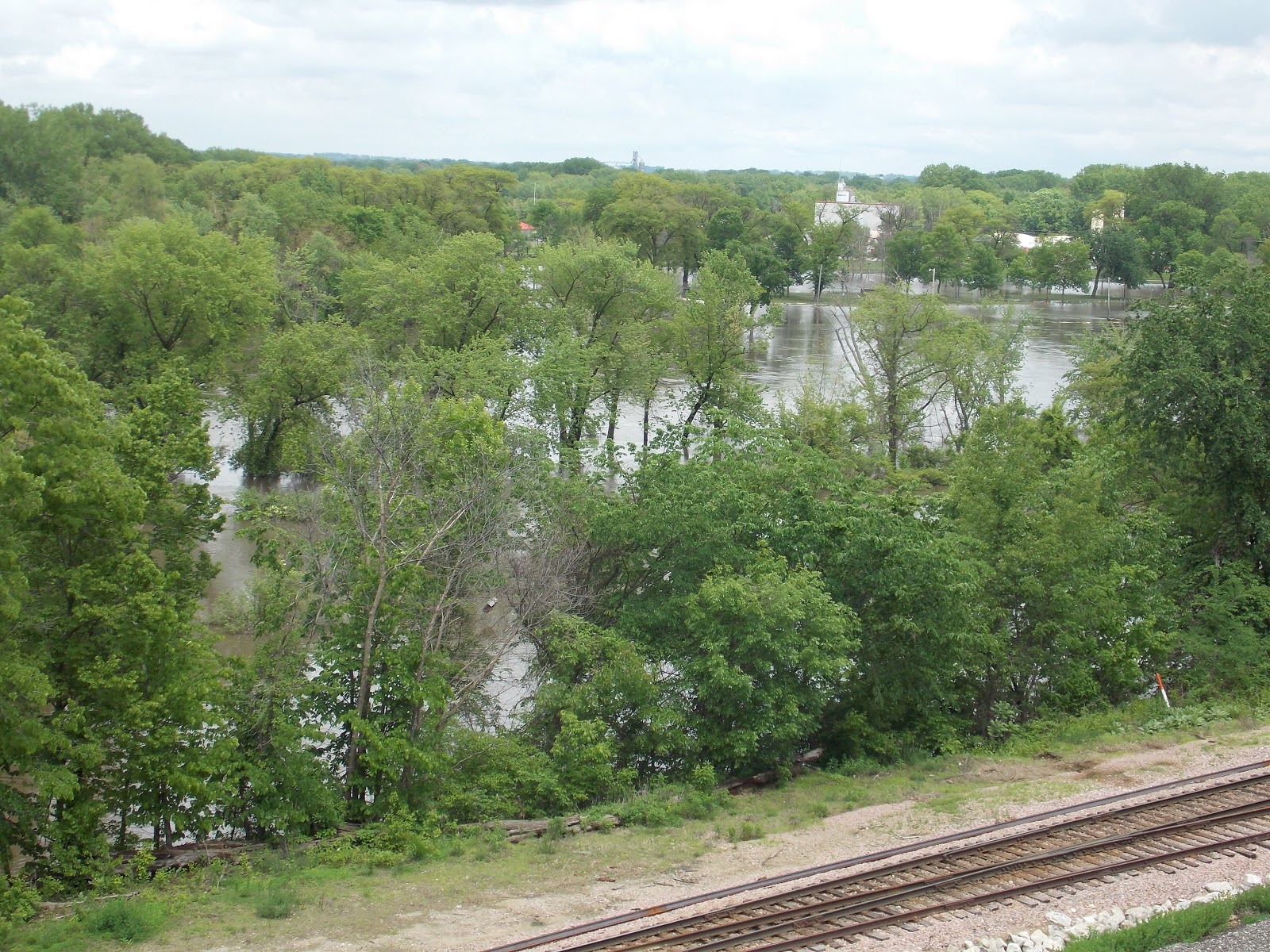
We parked in Cedar Falls about two years ago, at Black Hawk State Park.  Unfortunately it is now under water,  but we still had a couple other options opened to us when we arrived last Thursday.  Our second choice was filled up due to the holiday week-end and graduation events.  However, the owner of that park was kind enough to point across the Cedar River and show us where there was a church conference center which had about 10 spots for large recreational vehicles.  That is where we ended up parking.   And from that vantage point we could look over the river bluffs at the swollen Cedar River.

The river continues to flow swiftly and flood the low-lying areas of the city-  it most certainly will be one of the rivers feeding into the Mississippi and causing it also to flood.  John and I have seen a lot of rain in the past week, and according to weather reports, it probably will not let up until the end of this week.  As I commented when we were in St.Louis,  it is hard for John and I to understand all this dampness when we had such a dry winter in Texas!

We are in Cedar Falls for the high school graduation of our niece Martha and her husband Quique’s son Joshua.  They are pictured below along with their other children Becky, Joel and Lydia.  Grandparents Carolyn and Jim came up from Farmington to also join in the week-end festivities, which began with an open-house for Josh at their church on Friday evening.
And, despite the weather, John and I did find some dry time to get better acquainted with Cedar Falls.  Last time we were here we biked around the millrace and historic downtown area of the city.  This time we explored the streets of Cedar Falls which are lined with large Queen Anne and Victorian homes, many of which have been restored.  The older homes were built in the 19th century by successful businessmen who were associated with the numerous mills built along the river.  Cedar Falls is also an arts and entertainment destination.  Yesterday we stopped at the James and Mary Hearst Center for the Arts.  The center is comprised of two galleries, a recital hall and a sculpture garden.  It was while we were strolling around the garden  that we became acquainted with the work of James Hearst, an American poet, philosopher and professor. He has sometimes has been described as "Robert Frost of the Midwest".  Posted in the garden, amid many blooming flowers, are the verses which he has written.
Today, Thursday, we are headed to Omaha, where my sister Gloria and her husband live.

Friday, May 24, 2013

St.Louis Zoo

I apologize to our readers who probably thought we were done with St.Louis!  I had read somewhere, probably the St.Louis Post Dispatch, about a new sculpture at the zoo and got it into my head that I wanted to make a trip to the zoo before leaving town.  The zoo, like the botanical garden, is another gem of the St.Louis metropolitan area.  I have many happy memories there, beginning about 30 years ago when we started taking our children there.  And it has changed a lot over those years!  On Wednesday, when we visited the zoo, we needed a map to find our way around.  And yet I must add that the changes at the zoo have made it an even better place to visit!   An example of one of its changes can be found at the free flight aviary.  It was built in 1904 for the St.Louis World Fair, by the Smithsonian Institute for the Louisiana Purchase Exposition.  In 1973 it served as the centerpiece for the creation of the zoo.  Over the years what was once the world's largest bird cage became the home for a variety of bird species, many of them exotic.  Today it is a cypress swamp and home to many native bird species of Missouri.  Upon entering the aviary John and I immediately identified a variety of egrets and ducks in the swamp, and one yellow-crowned night heron perched in a tree.  Cormorants were sunning themselves on the boardwalk and completely oblivious to our presence.  I was able to get quite close to the one pictured below.
It was a perfect day to be at the zoo as many animals were out and active.  In the Red Rock area of the zoo we saw a mother zebra and her baby, as well as a young giraffe.   In the kangaroo pen the animals were zipping back and forth rapidly, making it quite difficult for me to get a picture of a mother and her joey.  Which explains how I happened to get a tail flying across the picture below.  Only the babies' hand is showing out of the pouch.  I thought it made for an interesting picture!
Also in the Red Rock area I was fascinated how an okapi fed off the leaves of a tree located in his enclosure.  Even from a distance away I could see his long tongue stretching up to the lower branches.  In another pen I saw a gerenuk feeding in the same manner.  What makes the zoo so interesting for me are the interpretive signs placed by each animal enclosure.  I learned from the posted information that the gerenuk requires very little water and may not drink at all during its lifetime.  He lives in different parts of Africa.
In the Discovery Corner of the zoo is the Insectarium, Children's Zoo and Living World.  I planned to avoid  looking at bugs until I learned that going though that building was the only way to visit the butterfly house.  It was worth putting up with the bugs!  The butterflies were numerous and beautiful- I could say ditto for the plants in the butterfly house.  A docent guarding the insects informed us that there are about 150- 200 butterflies on any given day located in the green house.  John and I have been in several butterfly houses but I must say that this one has to be one of the best in the country.  I had to restrain myself from taking numerous pictures.  Hopefully I have by now given you an urge to visit the St.Louis Zoo, and there is no entrance fee.

Monday, May 20, 2013

Chinese Culture Days at Missouri Botanical Garden

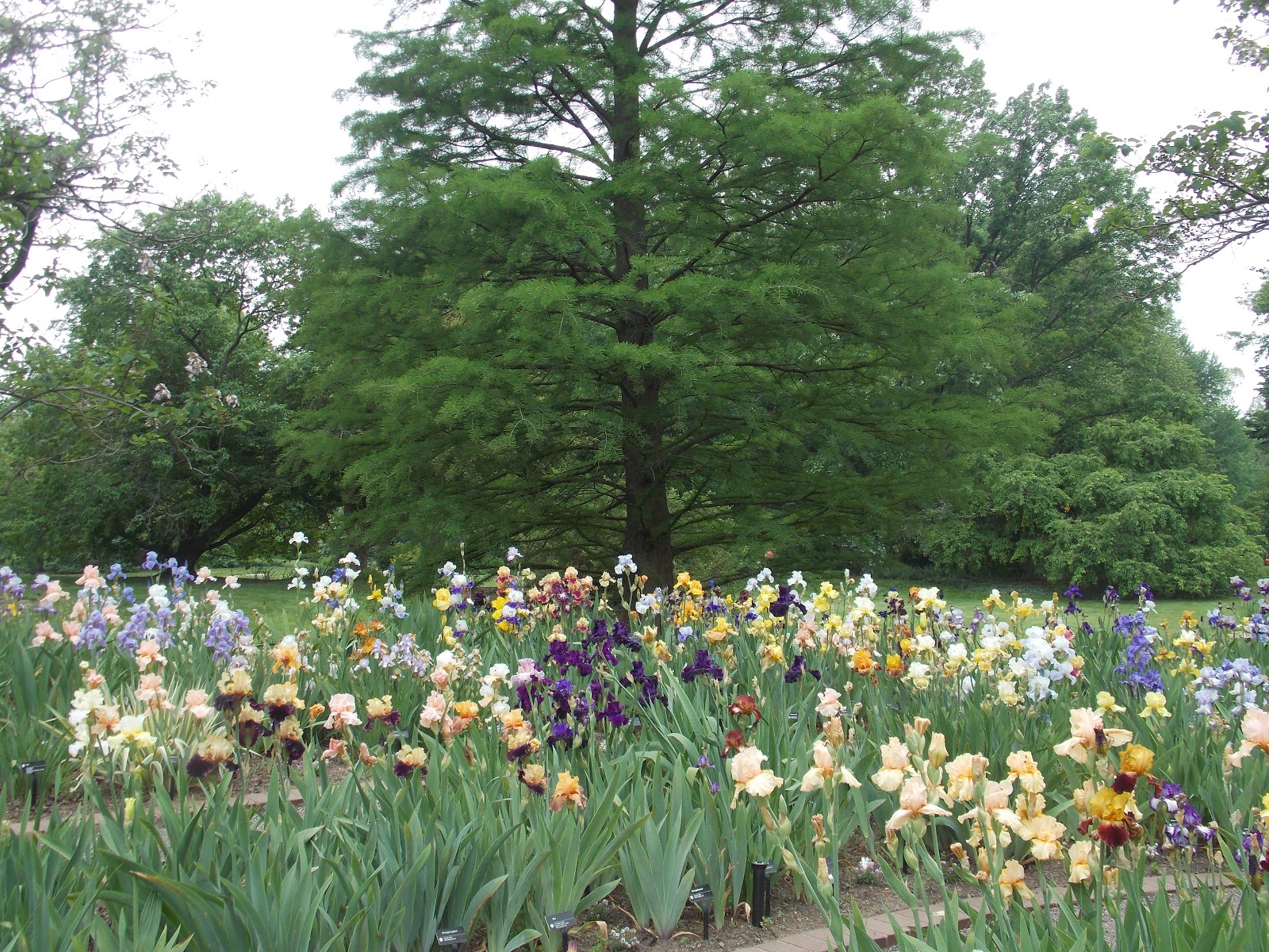
This is my second posting on the Missouri Botanical Garden, and if I remember correctly, when we visited the gardens last summer there was also some sort of Chinese cultural festival going on then.  However, as you will soon discover, this posting will not be a boring repeat of of our last visit there.  I hope all St.Louis citizens realize what a gem they have in the botanical gardens.  And if you live within that metropolitan area and never have paid the gardens a visit, I will just say shame on you!  Over the years we have been there during various seasons of the year. Each time there have been different plants in bloom, and new areas of the garden to explore.  It is just one of those places which never disappoints us.  Sunday afternoon my sisters Julia and Linda joined John and I for our visit to the gardens.  Currently, the big attraction in the garden is a large patch of blooming iris flowers.  What a beautiful riot of color!
Equally thrilling for us was a gorgeous display of blooming evergreen azalea, pictured below.  Also flourishing presently are the fragrant peony flowers, and the rose bushes are also well into their blooming season.
Since 1996 the Garden has collaborated with the Chinese Culture Education and Services Foundation to produce an event celebrating Chinese culture.  Two days of this past weekend were filled with Chinese pageantry, art and dance.  We were there only for the events on Sunday afternoon, which were the dragon dance and parade and the New Shanghai Circus.  The circus offered a juggling act, amazing acrobatics as well as charming mystical dancing.  One of the dances was called the changing of the masks.  We were too far back to figure out how it was done, but mysteriously somehow the dancer frequently changed his face mask.  As you may note in the picture below, his dancing costume was quite elegant.  My sisters, Julia and Linda commented that when they visited China they had seen a similar show there, however it was a bit different in that there more performers on the stage, all changing their masks as they danced.
Perhaps some of you are wondering how much longer we will be staying in St.Louis.  Thursday we are planning on moving our home north to Iowa and then westward.  Stay tuned for more Schramm adventures!